12/02/2019-18/02/2019
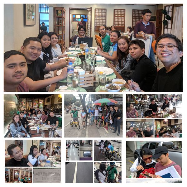
16 mappers doing field mapping in Marikina, Philippines 1 | © GOwin
[Actual Category]
- On March 23, 2019, an Action Day called Save Your Internet against the EU Copyright Directive is planned with demonstrations in many cities. On Saturday, February 16, the first, spontaneously organised demonstration, with about 1000 participants, took place in Cologne, as Heise Online reports (automatic translation).
- Julia Reda, the member of the German Piraten Partei in the European Parliament, has published on her website the current drafts for Article 11 (Linksteuer / Presseleistungsschutzrecht) and 13 (Uploadfilter) of the new EU Copyright Directive. She expects the vote to take place in the plenary sessions of Parliament between 25 and 28 March, on 4 April, or between 15 and 18 April.
- In a comment on netzpolitik.org, Markus Reuter calls (automatic translation) for action against the EU copyright directive in real life.
Mapping
- Nuno Caldeira announced on Twitter the excellent work done by the newly created Portuguese OpenStreetMap Telegram group mapping buildings on Porto Santo island, in the Madeira archipelago. They will do monthly mapping challenges, such as this one, to improve OpenStreetMap in Portugal.
- The decision of the StreetComplete maker to create challenges for adding default values like
foot=yesonhighway=residentialoraccess=yesonamenity=playgroundcaused lengthy discussions on the tagging mailing list and the forum (automatic translation).
 - Tshedy reported on the MapLesotho blog about an exhibition at Avani Maseru which was held with the help of Fingal County Council and Action Ireland Trust. The “tremendous progress from 2013 to 2018” in Lesotho was featured as image of the week on the main wiki page.
- [1] GOwin wrote a blog post about the first mapping party organised by MapaTime in Marikina, Philippines. Sixteen mappers showed up at the first field mapping activity since 2016, which started as early as 6:30 am. The picture-rich post also details the organisation of the event.
- The vote for the key
departures=, which is designed to indicate the departure times for any given stop, just started. The proposal follows the recent approval of the new keyinterval=for tagging the time between departures. - Voting for
natural=isthmus, for tagging a strip of land, bordered by water on both sides and connecting two larger land masses, and fornatural=peninsulahas recently started.
 (automatic
 Community
- Stefan Keller criticises Mapzen and the Linux Foundation, which recently took over Mapzen’s projects, for concealing the main data sources, the OpenStreetMap project, in their public announcements.
- Christian created an online map that displays the use of animals. In his blog he explains (automatic translation) that he is interested in animal protection-related open data.
- Chris Beddow and Daniela Waltersdorfer J wrote, in the Mapillary Blog, about the need for more detailed mapping of kerbs.
- The election for the OpenStreetMap US Board, which the weeklyOSM recently mistakenly called an OSMF chapter, will start on 25 February and end 28 February. Nominations for the OpenStreetMap US Board are open until Sunday 24 February.
Events
- Joost Schouppe announced this year’s Belgian National Mapathon, which is scheduled on:
- March 27 in Brussels (FR), Leuven, Louvain-la-Neuve and Mons
- March 28 in Brussels (NL), Liège, Namur and Ghent
- March 30 in Louvain-la-Neuve.and Liège.
- The SotM-France 2019 will take place from the 14 to 16 June in Montpellier.
Humanitarian OSM
- HOT has recently held a Tasking Manager Stakeholders’ Workshop in Washington, DC at which development goals for 2019 were discussed. The focus will be on the functionality to group users into suitable teams based on the users’ backgrounds, statistical features to improve mapping projects and their data quality, the introduction of machine learning workflows into mapping and the observation of usability and user flows.
- HOT features an article from Peter Ward from the GAL School in Cusco, Peru about the geodata collection for testing their hypothesis that closer rubbish bins means less rubbish on the ground.
Maps
- Lukas Loos, from HeiGIT, introduced a first beta version of the OpenStreetMap History eXplorer (ohsomeHeX). It uses ohsome (OpenStreetMap History Data Analytics Platform) to aggregate OSM data of a first set of selected features into a set of world-spanning hexagonal grids in a configurable temporal resolution. The goal is to allow the exploration of the history of OpenStreetMap data in time and space at varying scales. Further improvements are in the pipeline.
- Utagawa Hiroshige is one of the great masters of Japanese printmaking. George has created an OSM-based map that geolocalises “impressive images of Japan’s great landscape” made by Utagawa Hiroshige. Antoine Oury has written an article about this on ActuaLitté. (automatic translation)
 (automatic
Open Data
- On 13 February 2019, the Brandenburg state government, Germany, passed a bill amending the Surveying Act and providing for the future free use of geodata by surveying authorities. With the amendment to the law, digital geodata will, in future, be made available to the surveying authority free of charge. The offer covers nearly 330 digital data records and data services altogether. These include, for example, high-resolution aerial photographs, maps of roads and properties or the representation of entire landscapes and elevation models. Brandenburg publishes its open data on the Internet portal DatenAdler.de under the license dl-zero-de/2.0.
- The European Union has launched the third Eudatathon. Participants, who are asked to develop apps and visualisations using open data made available by the European Union, can win prizes of up to €15,000.
- Ellen Tannam published an interview on siliconrepublic.com with Séan Lynch, the man behind the project openlittermap.com. In the interview he explained his motivation, the benefits of OSM’s open data model and the hopes he has for his project in light of the global litter crisis.
Licences
- The OSMF Licence Working Group has written a Licence Compatibility guide for our current licence ODbL 1.0 and made the evaluation results of the Linux Foundation’s “CDLA (Community Data License Agreement) Permissive” licence available.
Software
- On Twitter, Quincy Morgan presented a preview of an upcoming feature for the iD-Editor, a tool that shows validation issues to the user while editing. In response to an enquiry from Pierre Béland, Quincy explains that, for example, the upload of untagged objects with
area=yeswill be blocked. A test version is available here. - The WordPress plugin OSM from MiKa is now compatible with WordPress 5.0. This version of the plugin supports the “Classic Editor” and the new “Gutenberg Editor”. MiKa has also implemented 200 new icons and support for the humanitarian OSM style.
Releases
- OSM’s main map style, Carto, has received another update. As the maintainer, Daniel Koć, wrote in his OSM diary, version 4.20.0 has added the rendering of
boundary=aboriginal_areaandboundary=protected_areawithprotect_class=24. The new version also dropped support forleisure=common, lightened major buildings and added support for oneway arrows for footways, cycleways and paths as well as a variety of other improvements. - OsmAnd was released in version 2.5 for Apple’s iOS operating system. The most notable new feature is access to their OsmAnd Live subscription. The app can be downloaded from the iTunes Store.
Did you know …
- You might have stumbled across fictional data in OSM. Now you can point the authors of such unwanted data to opengeofiction.net. Martijn van Exel asks for help to grow his fictional town and connect it to the rest of the world.
- Following her tweet that kerbs are become increasingly important nowadays, Daniela Waltersdorfer published an article about kerbs, why she thinks their importance is growing, opens questions with regards to mapping them in OSM and how “curbs”–or, as they should be correctly named “kerbs”–should be added in OSM. She draws special attention to transition points, i.e. where kerbs are lowered, as these are important features to pedestrians, cyclists, and especially to those with reduced mobility. On Twitter, Tobias Jordans points to the parking lane viewer/editor on zlant.github.io as an easy way to add parking information to OSM.
- … about the supplementary descriptions of the tags used for representing roads and paths as areas, resulting from the original proposal by Marek_kleciak? In 2018 Tomasz_W wrote wiki pages for area:highway= pedestrian, footway, path and cycleway, which are, however, currently at odds with the rules defined in the original proposal.
OSM in the media
- The Berliner Morgenpost used Hans Hack’s Figuregrounder tool to create a quiz that challenges its readers to identify Berlin locations on the basis of the building outlines from OSM data.
Other “geo” things
- Mapbox published a community impact summary for 2018, which highlights Mapbox’s social engagement and details some of the 167 non-profit projects they support.
- Listverse.com shows ten areas on Google maps where the borders between states are not clear.
- Users of ESRI’s ArcGIS Online have already contributed vector data and aerial images for background maps (“Community Maps”). Now ESRI also allows users to edit these data. The edit review process takes one week and inclusion in the main database takes up to three weeks. Needless to say, OSM is a bit faster.
- The New York Times used the Openrouteservice API to derive walking distances from major subway stations in New York City for their analytical piece “Where the Subway Limits New Yorkers With Disabilities”.
- Dmitry Filippov, a student of “Information technology and applied mathematics” at Moscow Aviation Institute (National Research University), created a startup, “Heavy Geeks”, where he transferred the map of the entire real world into the game “Parallel 42”.
Upcoming Events
| Where | What | When | Country |
|---|---|---|---|
| Padua | FOSS4G-IT 2019 (OSMit2019) | 2019-02-20-2019-02-24 |  |
| Greater Vancouver area | Metrotown mappy Hour | 2019-02-22 |  |
| Biella | Incontro mensile | 2019-02-23 | |
| Manila | 【MapaTime!】 @ co.lab | 2019-02-23 |  |
| Karlsruhe | Karlsruhe Hack Weekend February 2019 | 2019-02-23-2019-02-24 |  |
| Rennes | Créer ses propres cartes avec uMap | 2019-02-24 |  |
| Bremen | Bremer Mappertreffen | 2019-02-25 | |
| Digne-les-Bains | Conférence « Communs numériques – Cartes sensibles » | 2019-02-26 | |
| Viersen | OSM Stammtisch Viersen | 2019-02-26 | |
| Düsseldorf | Stammtisch | 2019-02-27 | |
| Ludwigshafen am Rhein | Mannheimer Mapathons – Stadtbibliothek LU | 2019-02-27 | |
| Zurich | Missing Maps Mapathon Zurich | 2019-02-27 |  |
| Lübeck | Lübecker Mappertreffen | 2019-02-28 | |
| Leoberdorf | Leobersdorfer Stammtisch | 2019-02-28 |  |
| Montrouge | Rencontre des contributeurs de Montrouge et alentours | 2019-02-28 | |
| Minsk | byGIS Meetup | 2019-03-01 |  |
| Amagasaki | IODD:尼崎港線アーカイブダンジョン | 2019-03-02 |  |
| Wuppertal | [Wuppertaler Opendata Day] | 2019-03-02-2019-03-03 | |
| London | Missing Maps London Mapathon | 2019-03-05 |  |
| Stuttgart | Stuttgarter Stammtisch | 2019-03-06 | |
| Praha/Brno/Ostrava | Kvartální pivo | 2019-03-06 |  |
| Dresden | Stammtisch Dresden | 2019-03-07 | |
| Nantes | Réunion mensuelle | 2019-03-07 | |
| Ivrea | Incontro mensile | 2019-03-09 | |
| Oslo | OSM-beer | 2019-03-08 |  |
| Rennes | Réunion mensuelle | 2019-03-11 | |
| Zurich | OSM Stammtisch Zurich | 2019-03-11 | |
| Taipei | OSM x Wikidata #2 | 2019-03-11 |  |
| Lyon | Rencontre mensuelle pour tous | 2019-03-12 | |
| Salt Lake City | SLC Mappy Hour | 2019-03-12 |  |
| Arlon | Espace public numérique d’Arlon – Formation Initiation | 2019-03-12 |  |
| Munich | Münchner Stammtisch | 2019-03-13 | |
| Dresden | FOSSGIS 2019 | 2019-03-13-2019-03-16 | |
| Berlin | 129. Berlin-Brandenburg Stammtisch | 2019-03-14 | |
| Scotland | Edinburgh | 2019-03-19 | |
| Portmarnock | Erasmus+ EuYoutH_OSM Meeting | 2019-03-25-2019-03-29 |  |
| Montpellier | State of the Map France 2019 | 2019-06-14-2019-06-16 | |
| Angra do Heroísmo | Erasmus+ EuYoutH_OSM Meeting | 2019-06-24-2019-06-29 |  |
| Minneapolis | State of the Map US 2019 | 2019-09-06-2019-09-08 | |
| Edinburgh | FOSS4GUK 2019 | 2019-09-18-2019-09-21 | |
| Heidelberg | Erasmus+ EuYoutH_OSM Meeting | 2019-09-18-2019-09-23 | |
| Heidelberg | HOT Summit 2019 | 2019-09-19-2019-09-20 | |
| Heidelberg | State of the Map 2019 (international conference) | 2019-09-21-2019-09-23 | |
| Grand-Bassam | State of the Map Africa 2019 | 2019-11-22-2019-11-24 |  |
Note: If you like to see your event here, please put it into the calendar. Only data which is there, will appear in weeklyOSM. Please check your event in our public calendar preview and correct it, where appropriate.
This weeklyOSM was produced by Nakaner, Polyglot, Rogehm, SunCobalt, TheSwavu, YoViajo, derFred, geologist, jinalfoflia, kartonage.