15/10/2019-21/10/2019
Mapping every single day 😉 1 | © altogetherlost.com & Pascal Neis (neis-one.org)
Mapping
- On regio-osm.de there is now a house number evaluator for Kosovo.
- Florian Lohoff wrote in his blog about the issues arising when
access=privateis used on service roads. Usually this choice means no routers will use these highways; more nuanced access options should be chosen instead. - Adam Franco created two videos about working with multipolygons using JOSM. The first one is about creating multipolygons for adjoining areas with shared ways. Please note that this type of mapping is being discouraged in many parts of the world. In his second video he explains how to identify and bugfix multipolygons.
- Valor Naram’s proposal to deprecate the tag
contact:phone=in favour ofphone=is up for voting until 5 November 2019. - Voting also started for Vɑdɪm’s proposal to tag outdoor locations designated for sunbathing. The poll ends on 5 November 2019.
- OpenStreetMap Croatia started their own instance of Tasking Manager (automatic translation) to better coordinate mapping and imagery recently made available from state sources. The first project is naming all the bays on the coast.
Community
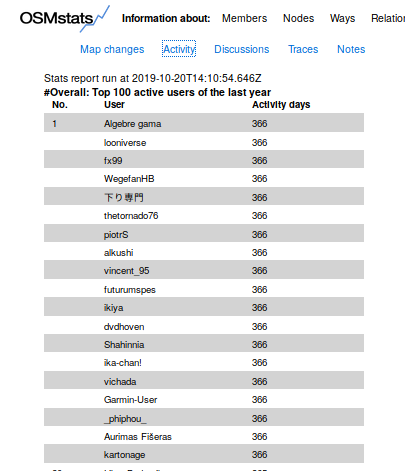
- [1] Pascal Neis added some “leaderboards” to his OSMstats. Exactly 19 users contributed and mapped every single day to OSM last year, as reported in “Activity”. It is also worthwhile to have a look at the other reports: Map changes, Discussions, Traces and Notes.
- Heather Leson points to a survey concerning people in FLO (Free/Libre/Open) communities.
- RebeccaF provides, in an OSM diary entry, a long list of potential action points for increasing diversity with OSM, HOT and State of the Map. These points came out of the session at SotM Heidelberg.
- OSM plays a key role in a dynamic earthquake risk model that processes updates on buildings every 60 seconds.
Imports
- Data from the Estonian cadastre has been imported into OSM since 2013. OSM user SviMik has now developed a convenient and simple tool to maintain updates. He also created a validator that tells you where to add new and missing roads in Estonia. An overview of statistics and all tools is available on his personal site
 ; there is still scope for help from the community.
 ; there is still scope for help from the community.
Events
- Betaslb wrote (automatic translation) in her user diary about her experience at the SotM 2019, including some inner thoughts from someone who is not an expert in OSM, but a beginner.
- The registration for SotM Asia 2019 is open. SotM Asia takes place in Dhaka, Bangladesh 1 and 2 November 2019 .
Humanitarian OSM
- Riley Champine, graphics editor at National Geographic, tweeted a link to slides of his presentation at NAICS 2019 on Mapping Refugees with Open Data. A bonus is the link to a Google Spreadsheet of a range of Overpass queries he used.
Education
- Russian user Pavel Gavrilov wrote a tutorial on OSM which can be useful for beginners. He talks about the project basis.
Maps
- Russian user Nikolay Petrov launched an online project OpenRecycleMap . This is a map which helps in finding recycling collection points. The service also allows users to add new waste collection points. Data is taken from OSM and then added to it.
- maptiler.com published a blog post about the new offering of OSM in WGS84, French Lambert and Dutch Rijksdriehoekstelsel map projections. The article also provides a brief overview of map projections and links to Tobias Jung’s interesting comparison of selected map projections.
- The Ministry of Industry and Trade of the Russian Federation has developed the “Geoinformation system of industrial parks, technoparks and clusters of the Russian Federation”, which uses OSM as a basemap.
switch2OSM
- The Russian portal E1 reports (automatic translation) that new smart traffic lights will start operating in Yekaterinburg in November 2019. They will give priority to public transport. On one of the photographs you can see that the traffic control system uses OSM as a map.
Open Data
- data.gv.at has advertised their new sticker via Twitter. These can be purchased at OpenData events such as @gov20campAT, which will take place (automatic translation) on 29 November 2019.
- The first Scottish Open Data Unconference takes place in Aberdeen on 14 and 15 March 2020.
- The city administration of Perm (a city in Russia) gave a permission to use data from “ISOGD Public Portal of Perm” in OSM.
 their new sticker via Twitter. These can be purchased at OpenData events such as @gov20campAT, which will
 Licences
- The discussion about Facebook and missing attribution is still going on. On the one hand Christoph emphasises that the discussion and development of a new community guideline does not happen in the open. On the other hand, Nuno Caldeira details the licence infringement and supplies some detailed examples.
Software
- Jody Garnett asks via Twitter whether members of fossgis_eV would be willing to support GeoServer with OGC recertification measures.
Programming
- Shay Strong of EagleView wrote, on the KD Nuggets site, about an approach to using machine learning to identify unmapped buildings on OpenStreetMap. Update: Her model is bootstrapped with known buildings on OSM.
- Jochen Topf reported about his experiences with the Hetzner cloud, into which he has moved data.openstreetmap.de (formerly openstreetmapdata.com).
- Andy Allan wrote on his blog about progress being made in refactoring the core code of OpenStreetMap to allow supporting multiple API versions at the same time.
Releases
- Version 3.0.0 of PostGIS has been released.
- Version 2.3.0 of the “Sight Safari” mobile application has been released . Now you can share routes with other users right from the app and also create intermediate points on the route.
Did you know …
- … of the website of Russian user AMDmi3? You can find various OSM renders there.
Other “geo” things
- The Guardian has an amusing article where a journalist confronts teenagers with outmoded technologies of the 1980s, including rotary dial telephones, a Sony Walkman, and a transistor radio. One of the examples is a printed street atlas of London (the “A-Z”).
- We reported last week on the demise of paper maps from Geoscience Australia. Now The Guardian has an in-depth reflection on this announcement.
- Jens Jackowski reported (automatic translation) from Sweden and says: “interesting, now the Swedish land surveying office is already calling on citizens to improve the official Swedish maps and, for example, to report missing hiking trails.” We say: “Then we’d better work with OpenStreetMap right now.”
- James Macfarlane believes that the increased use of navigation apps like Waze, Apple Maps, and Google Maps is multiplying chaos and making it harder to manage traffic.
- An article in futurezone.at shows (automatic translation) that map errors do not always have to be seen negatively. Due to an error in Google Maps a drug gang was caught.
- El Pais noted (automatic translation) that military maps of Spain, compiled during World War II by the Americans and British, have finally been de-classified.
- Google announced that in the future it will be possible to report traffic incidents such as accidents and breakdowns on Google Maps. Google bought Waze six years ago and adding these features to Google Maps raises questions about Waze’s future.
- A paper in Ecography demonstrates how textual analysis of scientific papers can be used to create maps of where studies of various insect pollinators (typically bees) have been carried out.
 (automatic
  (automatic
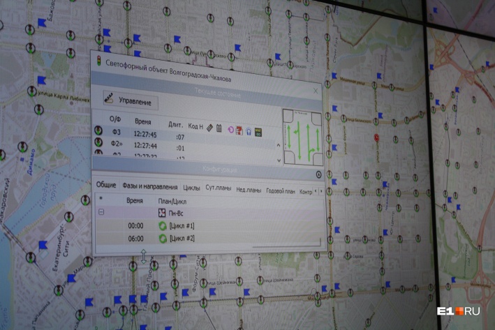
Upcoming Events
| Where | What | When | Country |
|---|---|---|---|
| Prizren | State of the Map Southeast Europe | 2019-10-25-2019-10-27 |  |
| Rapperswil | 11. Micro Mapping Party Rapperswil (OpenStreetMap Mapathon) | 2019-10-25 |  |
| Yosano-chō | 京都!街歩き!マッピングパーティ:第13回 ちりめん街道 | 2019-10-27 |  |
| Bremen | Bremer Mappertreffen | 2019-10-28 |  |
| Zurich | Missing Maps Mapathon Zürich | 2019-10-30 | |
| Düsseldorf | Stammtisch | 2019-10-30 | |
| Ulmer Alb | Stammtisch Ulmer Alb | 2019-10-31 | |
| Dhaka | State of the Map Asia 2019 | 2019-11-01-2019-11-02 |  |
| Brno | State of the Map CZ+SK 2019 | 2019-11-02-2019-11-03 |  |
| London | London Missing Maps Mapathon | 2019-11-05 |  |
| Stuttgart | Stuttgarter Stammtisch | 2019-11-06 | |
| Bochum | Mappertreffen | 2019-11-07 | |
| San José | Civic Hack & Map Night | 2019-11-07 |  |
| Montrouge | Rencontre mensuelle des contributeurs de Montrouge et alentours | 2019-11-07 |  |
| Dortmund | Mappertreffen | 2019-11-08 | |
| Budapest | OSM Hungary Meetup reboot | 2019-11-11 |  |
| Taipei | OSM x Wikidata #10 | 2019-11-11 |  |
| Lyon | Rencontre mensuelle pour tous | 2019-11-12 | |
| Salt Lake City | SLC Mappy Hour | 2019-11-12 | |
| Nitra | Missing Maps Mapathon Nitra #4 | 2019-11-12 |  |
| Wellington | FOSS4G SotM Oceania 2019 | 2019-11-12-2019-11-15 |  |
| Hamburg | Hamburger Mappertreffen | 2019-11-12 | |
| Munich | Münchner Stammtisch | 2019-11-13 | |
| Prešov | Missing Maps Mapathon Prešov #4 | 2019-11-13 | |
| Berlin | 137. Berlin-Brandenburg Stammtisch | 2019-11-14 | |
| Nantes | Réunion mensuelle | 2019-11-14 | |
| Encarnación | State of the Map Latam 2019 | 2019-11-14 |  |
| Grand-Bassam | State of the Map Africa 2019 | 2019-11-22-2019-11-24 |  |
| Cape Town | State of the Map 2020 | 2020-07-03-2020-07-05 |  |
Note: If you like to see your event here, please put it into the calendar. Only data which is there, will appear in weeklyOSM. Please check your event in our public calendar preview and correct it, where appropriate.
This weeklyOSM was produced by Elizabete, Nakaner, Polyglot, Rogehm, SK53, Silka123, SunCobalt, TheSwavu, YoViajo, derFred, geologist, jinalfoflia.
Please correct Shay Strong listing. Shay Strong is a woman. See https://www.linkedin.com/in/shay-strong/
You don’t tell us where and how to vote on the changes to tagging. That’s pretty basic. I would bet that most readers have no idea how to vote. So much for inclusions!
The word “proposal” is a link to the actual proposal. At the bottom of that page you find a voting section (with instructions).
FYI, here is the wiki page on the tag proposal process: https://wiki.openstreetmap.org/wiki/Proposal_process
This news short needs more explanation “[1] Pascal Neis added some “leaderboards” to his OSM stats. Exactly 19 users contributed and mapped every single day to OSM last year, as reported in “Activity”. It is also worthwhile to have a look at the other reports: Map changes, Discussions, Traces and Notes.”
For someone who contributes as much to OSM as Pascal does, you should have given some background for those of us who don’t follow his stats. What stats does he keep? What do you mean by “leaderboards.” What is “Activity”? One of his categories? Why is there no link to his pages so we can look at his work? You need to spell out the details in these reports. Most readers do not follow this stuff every day.
“Heather Leson points to a survey concerning people in FLO (Free/Libre/Open) communities.” What is the name of the survey? Who is conducting it? What is the purpose? Can anyone participate? What does it have to do with OSM?
C’mon guys! Most high school newspapers can do a better job than this?
“Riley Champine, graphics editor at National Geographic, tweeted a link to slides of his presentation at NAICS 2019 on Mapping Refugees with Open Data. A bonus is the link to a Google Spreadsheet of a range of Overpass queries he used.”
So, what’s the link to his slides or to his Twitter page? Of the link to the Google spreadsheet?
The word “tweeted” is a link to his tweet. From there you find all the links you need. I see no reason to repeat such information in the Weekly OSM. I’m used to a Weekly OSM containing only headlines. The rest of the information can be found on the linked webpage.
For me, it would be a bad thing that the texts would be longer and take more time to go over. If I am interested in a topic I will click a link. No need for Weekly OSM to give an executive summary. A headline is sufficient for me.
Dear Charlotte,
We are always interested in improving our reporting.
The basic idea at weeklyOSM is that the reader opens the links and then continues there.
I hope that this is also the case in the cases mentioned by you.
Please consider what we do, we all do it on a voluntary basis in our spare time. You pick out 3 or 4 messages that you think should be reported in more detail. Can you imagine that this is simply not possible for about 40 messages that we produce weekly? Just for information – the proofreading of an issue usually takes 90 minutes!
We would like to invite you to use our guest mode and then – as you wish – report more about the respective links.
If you want to do that, just go here: https://osmbc.openstreetmap.de/, login with your OSM account – collect a link and write your report. It will then appear at least in the English edition. I can’t guarantee that it will be translated into the other languages.
cheers
Manfred
Manfred,
You mention links in stories. I found no links in the stories I commented on. I tried by clicking on the headline. Nothing. Then I clicked on the body of the story. Nothing.
So, how does one get to the links that you mention?
Charlotte,
assuming you are reading the Weekly OSM on this page, all words that are not black are links to other webpages.
Here a short howto : http://weeklyosm.eu/this-news-should-be-in-weeklyosm