03/10/2017-09/10/2017
Cycle node networks and mountain passes 1 | © Richard Fairhurst – Map data © OpenStreetMap contributors
About us
- For more than two years now, TheFive has been developing a content management system called OSMBC (OSM Blog Collector) to meet the special requirements of the editors of weeklyOSM. Without this FOS software, which has been continuously developed since then, it would impossible to publish the blog almost simultaneously in six languages. Thank you TheFive! TheFive has recorded the development in a blog post worth reading and shows that this tool can also be used in other environments easily.
Mapping
- Harry Wood updates a list of the longest name tags in OSM. There are now 80 more of them than last year.
- The mailing list tagging discusses whether
aeroway=airstrip, which originates from the New Zealand LINZ import, is a legitimate tag or whether you should useaeroway=runwayinstead. - There is a proposal to start distinguishing between public transport bus and coach services. Coach would be a long distance service, that skips most of the stops regular buses would serve and where coach buses with a different level of comfort are used.
- The feature proposal for sinkholes refinement needs more votes to pass, so voting was extended.
- Martijn van Exel came up with a better way of tagging center turn lanes, compared to the one he used initially when turn:lanes mapping wasn’t established yet.
- Martijn van Exel tries to formulate his own definition of
highway=trunkin the US. He also notes a few places in Utah where the current tagging doesn’t meet his expectations and is asking for help. - User westnordost announced in the German forum that his application StreetComplete will tag from the next version
maxspeed:type=*. There is criticism for his “top-down approach”. - Discussions about
wikidata=*tags are ongoing (which we reported in our two previous issues):- Frederik Ramm asks to pause any automated, semi-automated, query-driven, “challenge” driven edits on Wikidata tags in OSM until ongoing discussions have come to an end.
- People at the German OSM forum discuss
 (automatic translation) how much Wikidata in OSM is useful.
 (automatic
 Community
- Michal Migurski tweets that OpenStreetMap contributors are listed in the credits of the new feature film Blade Runner 2049.
- There is a call for membership to join OSMUK to improve OSM in the UK.
- Around thirty members from Projet EOF association have started this week in 8 different countries (Benin, Burkina Faso, Ivory Coast, Haiti, Mali, Niger, Senegal and Togo) to implement 15 workshops (each one with a duration of five days) about OpenStreetMap, free Geomatics and open data, in capital and regional cities, 15 mapathons and 21 one-day workshops that will reach at least 150 people during October. Follow it on Twitter through #ActionOifProjetEOF.
- Rebecca Firth has written (.pdf download, 4.5 MB) an article for the journal – “Science Without Borders: Making the SDGs successful” about OpenStreetMap and the Sustainable Development Goals (SDG). You can read more about the SDGs on Wikipedia.
- On October 7, 2007, version 0.5 of the OpenStreetMap API (and thus of the data model) went into production – 0.6 is the current version. Martin Raifer reminds us of this in his user blog and that many API calls, which we find to be commonplace today, were introduced back then.
Imports
- Christoph Hormann suggests to prefix any tag that was added by a bot with
bot:in the key. He hopes this could help us to overcome the problem of the increase of (bad) mechanical edits. - Abishek Nagaraj published a paper with the title Information Seeding and Knowledge Production in Online Communities: Evidence from OpenStreetMap. As data of two different stages of age and quality was imported during the TIGER import, he could analyse the effect on so-called information seeding on later contributions. He measured that counties with the older TIGER data got 38.8 % more contributions than the control group and concludes that information seeding is not as beneficial as assumed. There is also a small discussion on the Talk mailing list.
OpenStreetMap Foundation
- The minutes of the IRC meeting of Communications Working Group on 28th September is online.
Events
- In the town of Chiavari (Liguria, Italy), teams composed by one mapper and one volunteer from the Protezione Civile (Civil Protection, governmental body which deals with exceptional events management) ran a pilot data collecting project (organised by the municipality and the CIMA Foundation) focused on a flood scenario alongside the Rupinaro creek. While the volunteers collected information of the buildings (levels, entrances and flood preparedness), the mappers improved OpenStreetMap adding the details in the area, and photomapped with Mapillary. Local newspapers (automatic translation) and tv stations reported.
- The DINAcon 2017 conference will take place in Berne on 20th October. It is intended to correspond to the development of open data and digital sustainability. Among other things, there is a session on “Using OpenStreetMap for sitemaps and online stories” with Michael Spreng and Stefan Keller. The DINAcon Awards will also be presented at this event. Simon Poole, Michael Spreng and Stefan Keller are also nominated, representing the community. Simon Poole will also offer a lightning talk.
Maps
- Nils Vierus has published a map service to find ATMs, thus stimulating a lengthly discussion on the tags used at ATMs and banks
network=,operator=andbrand=. (automatic translation). Has there ever been a quarterly project on this subject? – Maybe together with communities from other countries? 😉
Software
- Anton Khorev wrote (automatic translation) down his opinion in regard with the usability of MAPS.ME as OpenStreetMap editor and the resulting changesets.
- In a commentary to an old article by Roland about Overpass, user mmd refers to his branch and related test measurements, which suggest a significant reduction in the daily CPU consumption.
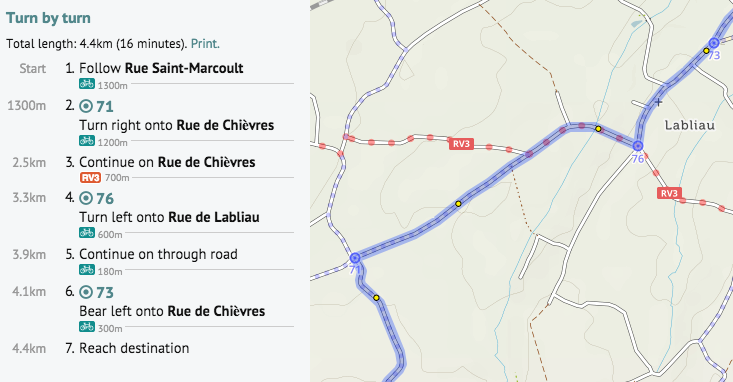
- [1] Richard Fairhurst enhanced turn-by-turn instructions on his website cycle.travel. They now mention node numbers of cycle node networks and the names of mountain passes along the route.
 (automatic
 Programming
- Sven Geggus wonders if the new PostgreSQL 10.0 combined with PostGIS 2.4 brings advantages for an osm2pgsql database. The gain is less for the standard use case, but the increased parallel processing abilities will be beneficial if the database will be used for further analysis.
- Pascal Neis describes how to conveniently process compressed OSM.PBF files with Java.
- Christoph Hormann has written a blog post about landcover rendering on small zoom levels.
Releases
- The stable version of JOSM contains the following major enhancements:
- Add links to external changeset viewers to the History and Changeset windows
- Allow users to request feedback when uploading by adding the review_requested=yes changeset tag
- Automatically uses a proper node count when creating circles depending on the diameter
- Extends the command line interface parameters
- OSMaxx has been updated: In addition to the existing formats, the original OSM format (pbf) and the universal shape file of the future, GeoPackage (gpkg), can now be exported.
- Mapbox shares the release about their support to React Native Mapbox GL and started a rewrite of their current experimental React Native library and released an alpha.
- … for further information please refer to the OSM Software Watchlist.
Did you know …
- … the Restriction Analyzer (for turning restrictions etc.) of MorbZ?
- … Sorted Cities by Hans Hack?
- … the TORFLOW map?
Other “geo” things
- How are urban areas in Australia connected with Sydney. Topi Tjukanov visualized it using QGIS, GraphHopper and OpenStreetMap data.
- Bollards were often re-used cannon.
- Salvatore Fiandaca has collected the previous splash screens of QGIS.
Upcoming Events
| Where | What | When | Country |
|---|---|---|---|
| Hérault | Opération libre à Jacou, Jacou | 2017-10-13-2017-10-15 |  |
| Calvados | Cartoparties de la presqu’île (arbres, environnement et déchets) lors du « Turfu Festival » et de la Fête de la Science, au Dôme de Caen | 2017-10-13-2017-10-15 | |
| Shizuoka | まちゼミ オープンストリートマップで地図を作ろう | 2017-10-15 |  |
| Bonn | Bonner Stammtisch | 2017-10-17 |  |
| Lüneburg | Mappertreffen Lüneburg | 2017-10-17 | |
| Scotland | Pub meeting, Edinburgh | 2017-10-17 |  |
| Karlsruhe | Stammtisch | 2017-10-18 | |
| Brest | Mapathon Missing Maps à l’UBO Open Factory | 2017-10-19 | |
| Leoben | Stammtisch Obersteiermark | 2017-10-19 |  |
| Colorado | Boulder]] | State of the Map U.S. 2017, [[Boulder | 2017-10-19-2017-10-22 |
| Hamburg | Design the Smart Mobility Hackathon | 2017-10-20-2017-10-21 | |
| Kyoto | 幕末京都マッピングパーティ#00:志士たちの今 | 2017-10-21 | |
| Karlsruhe | Hack Weekend October 2017 | 2017-10-21-2017-10-22 | |
| Buenos Aires | FOSS4G+State of the Map Argentina 2017 | 2017-10-23-2017-10-28 |  |
| Bremen | Bremer Mappertreffen | 2017-10-23 | |
| Taipei | OpenStreetMap Taipei Meetup, MozSpace | 2017-10-23 |  |
| Graz | Stammtisch Graz | 2017-10-23 | |
| Dusseldorf | Stammtisch Düsseldorf | 2017-10-23 | |
| Lyon | Mapathon Missing Maps à La Tour Du Web | 2017-10-24 | |
| Nottingham | Nottingham Pub Meetup | 2017-10-24 | |
| Chur | Mapping Party Chur | 2017-10-24 |  |
| Bern | Mapping Party Bern | 2017-10-25 | |
| Leuven | Leuven Monthly Meetup. Topic: Rendering for print | 2017-10-25 |  |
| Minsk | byGIS meetup | 2017-10-25 |  |
| Brussels | FOSS4G Belgium 2017 | 2017-10-26 | |
| Lübeck | Lübecker Stammtisch | 2017-10-26 | |
| Lima | State of the Map LatAm 2017 | 2017-11-29-2017-12-02 |  |
| Yaoundé | State of the Map Cameroun 2017, lors des premières Journées nationales de la Géomatique | 2017-12-01-2017-12-03 |  |
| Bonn | FOSSGIS 2018 | 2018-03-21-2018-03-24 | |
| Milan | State of the Map 2018, (international conference) | 2018-07-28-2018-07-30 |  |
Note: If you like to see your event here, please put it into the calendar. Only data which is there, will appear in weeklyOSM. Please check your event in our public calendar preview and correct it, where appropriate.
This weeklyOSM was produced by Anmaca, Nakaner, Peda, PierZen, Polyglot, SK53, SeleneYang, Softgrow, Spanholz, YoViajo, derFred, jcoupey, jinalfoflia.
Inside
Other “geo” things
This line is incorrect. I’m not the author of thi work, but Salvatore Fiandaca
….
Luca Mandolesi has collected the previous splash screens of QGIS.
Please, replace the line in this way:
Salvatore Fiandaca has collected the previous splash screens of QGIS.
Hi Luca, thanks for the information
@Salvatore Fiandaca – sorry for the mistake
updated in all languages 😉
thank you!!!
There’s still an issue when you parse wikilinks for cities (see Boulder) because the wiki link target includes a comma (not displayed on the wiki). You still have problems parsing links correctly, they should be unbreakable between square braces (“[URI text]” for external links or “[[Article name|text]] for wikilinks”) even if the URI or wiki article name contain a comma.