08/02/2024-14/02/2024

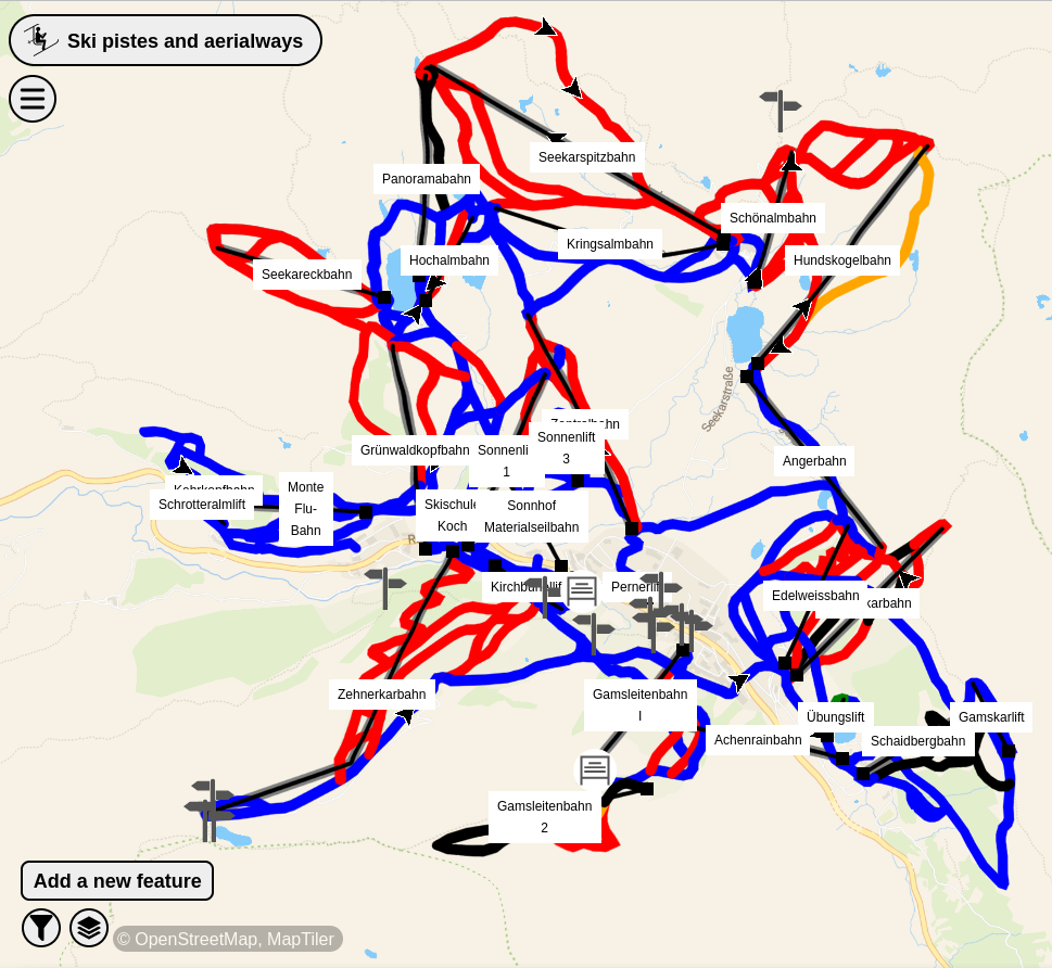
Piste da sci e viste aeree in MapComplete [1] | © MapComplete, MapTiler | map data © OpenStreetMap contributors
Ultime notizie
- Il gruppo di lavoro OpenStreetMap Engineering annuncia che
>
il 2024 sarà l’anno delle mappe vettoriali di OpenStreetMap e che Paul Norman è stato assunto per lavorare al progetto. Le mappe vettoriali rappresentano un progresso significativo rispetto alle tradizionali mappe raster (immagini statiche). Sarà possibile offrire mappe multilingue, punti di interesse interattivi, mappe più accessibili per gli utenti ipovedenti, stili tematici e una migliore integrazione di altri set di dati.
Mappatura
- Valerie Norton si chiede
>
come mappare una montagna il cui punto più alto ha un nome diverso. Esistono diverse soluzioni oggi utilizzate e l’autrice ne descrive e giustifica alcune.
Progetti di mappatura
- OpenStreetMap Bengaluru, India, ospiterà
>
un evento di mapping party il 24 febbraio 2024.
Comunità
- Anne-Karoline Distel condivide
>
la sua esperienza di mappatura durante una vacanza a Malta.
- La domanda posta nel nostro numero #707 se il nodo con il maggior numero di tag in OSM fosse effettivamente quello con il maggior numero di tag ha spunto
>
Minh Nguyen a fornire una risposta istruttiva. Tra le altre cose, mostra come il motore SPARQL QLever di Hannah Bast e altri – ospitato dall’Università di Friburgo – possa essere utilizzato per determinare facilmente i “primi dieci nodi” in OSM.
OpenStreetMap Foundation
- Arnalie Vicario ha passato in rassegna
>
i risultati ottenuti durante il suo mandato come membro del consiglio della OpenStreetMap Foundation nel 2023 e ha illustrato i suoi piani futuri per il 2024.
Educazione/Formazione
- Raquel Dezidério Souto ha creato un flusso di lavoro
>
dedicato ai mappatori principianti e per la mappatura dei dati POI in OSM e la loro visualizzazione dinamica con uMap.
- Per saperne di più sull’interesse per un’eventuale formazione del gruppo di validazione dei mappatori delle Nazioni Unite e sulle pratiche di validazione della comunità OSM globale in generale, il team di crowdsourcing di UN Maps ha condotto
>
questo sondaggio tra la comunità e ha presentato i primi risultati in forma grafica
- umbraosmbr segnala
>
un corso online gratuito di 60 ore di mappatura e geoprocessing con QGIS
come progetto di estensione del corso di Geografia dell’UNESPAR (Università Statale del Paraná).
OSM research
- IVIDES.org sta sviluppando una mappatura collaborativa
>
per informare sugli aspetti legati alla riduzione del rischio di disastri nel Comune di Maricá (Brasile). La ricerca è spiegata qui
>
.
Programmazione
- Il team operativo di OpenStreetMap ha annunciato
>
il ritiro del supporto OAuth 1.0a e HTTP basic auth per il sito web e le API di OpenStreetMap il 1° giugno 2024. Gli utenti di questi servizi dovranno migrare al sistema OAuth 2.0.
Rilasci
- [1] MapComplete ha aggiunto
una mappa tematica per lo sci che presenta una visualizzazione 3D dei contorni del terreno.
- È stata rilasciata
>
la versione 1.11.0 di Osm2pgsql.
Lo sapevi che…
- … puoi esplorare le visualizzazioni delle modifiche recenti ai dati di OpenStreetMap fino agli ultimi 30 giorni?
- … OpenStreetMap ha implementato una politica di limitazione sulla velocità degli edit per affrontare il problema del vandalismo?
- … qui ci sono tutte le mappe “wiki” non commerciali e indipendenti
>
basate su OSM che Aliya Kutueva elenca nel suo blog?
OSM nei media
- OpenStreetMap.org si sposterà
>
dalla grafica raster a quella vettoriale per la sua mappa principale, promettendo la selezione della lingua e viste dinamiche e personalizzabili con zoom continuo e viste 3D per un uso più efficiente dei dati e una visualizzazione moderna delle mappe.
Altre cose “geo”
- Swisstopo, l’Ufficio federale di topografia della Svizzera, ha recentemente aggiornato la sua applicazione disponibile gratuitamente. Dopo l’aggiornamento, l’app dispone ora di una “mappa di base”. Questa mappa di base è una visualizzazione di mappe continuamente scalabile, ottimizzata per la leggibilità e l’uso con smartphone, con molte informazioni e dati in tempo reale provenienti da varie fonti (incluso OSM). L’app Swisstopo dispone di mappe per la Svizzera e il Principato del Liechtenstein.
- Alan McConchie ha condiviso
una mappa linguistica dei dialetti inglesi del Nord America.
Prossimi eventi
Nota: Se vorresti vedere qui elencato il tuo evento, per favore inseriscilo nel calendario. Solo i dati che sono inseriti lì appariranno nel notiziario.
Questa Notiziario Settimanale OSM è stato prodotto da Mannivu, Michael Montani, Strubbl, TheSwavu, derFred, isoipsa.