09/04/2019-15/04/2019
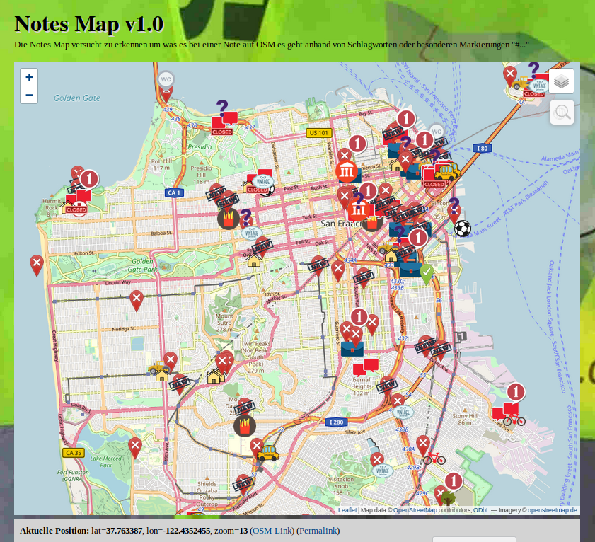
Notes Map, categorises notes reported on OSM’s website based on its content 1 | © Leaflet | Map data © OpenStreetMap contributors, ODbL — Imagery © openstreetmap.de
Mapping
- Joseph Eisenberg restarted the proposal process for
camp_site=camp_pitch.The tag has already been used over 6800 times to add individual tent or caravan spots within atourism=camp_sitearea. - Joseph Eisenberg also proposed
golf=cartpathfor golf cart paths, rather thanhighway=pathorhighway=servicewithgolf_cart=designated. - The tag
shop=fashion_accessories, which was suggested by SelfishSeahorse for shops focusing on selling fashion accessories, was approved. - The tag
place=localityis currently used about 1.3 million times. The tag is used for a lot of different purposes such as ghost towns and railway junctions in the USA or in combination withlocality=townlandandlocality=subtownlandin Ireland. This led Joseph Eisenberg to ask whetherlocality=*could be used to specify the type of locality. - Since 15 March, about seven-eighths of all associatedStreet relations in Germany have been replaced by tags on the buildings. The proportion of redundant relations has been reduced from 58% to 7%. dktue posted a simple evaluation (automatic translation) on the forum.
Community
- Tigerfell invited all contributors to vote about the proposed Deletion policy for wiki pages and files.
- Alan McConchie wrote a blog post with his thoughts about the unusual election for the OpenStreetMap US Board. Four candidates — Jonah Adkins, Ian Dees, Bryan Housel and Alyssa Wright — were approved by a simple confirmatory vote and Minh Nguyễn was elected by a ranked choice voting for the seat vacated by Maggie Cawley. In his post, he explains the details of those voting procedures. Maggie Cawley resigned six weeks after being re-elected to take on the role of executive director of OSM US.
- The Conversation, a website for news from the academic and research community, published an article entitled Better city bike maps are made by volunteers, largely based on investigations of data from Canadian cities. It concluded that OSM is more up-to-date and includes more local details than many other sources, including data from the Open Data portals of the cities studied.
- Martijn van Exel introduces a simple approach on how to measure the “well mapped-ness” (or just „mappedness”) of a town in OSM. In his step-by-step guide he explains how he used the
name=tag as a proxy for POIs, which he then uses to define completeness, and to visualise the „mappedness”.
Imports
- The Swedish community plans to import landuse data from the Swedish Environmental Agency (Naturvårdsverket). A discussion about this is on the mailing list talk-se. (automatic translation)
- Japan’s Ministry of Agriculture, Forestry and Fisheries (MAFF) recently published
 (automatic translation) farmland data for the whole of Japan. nyampire provides some details about this huge dataset with 30,951,173 polygons. He concluded that an import „..could be challenging”.
 (automatic
 OpenStreetMap Foundation
- The minutes of the 14 March meeting of the License Working Group of the OSMF have been published.
Events
- Christine Karch, chair of SotM Working Group, points out, once more, an important deadline via a tweet. The deadline for the „Call for Presentations” for this years’ conference in Heidelberg is next Thursday, 25 April 2019. Here is the link to register your presentation.
- Neil Matthews will be presenting an Intro to OpenStreetMap at the Open Data Bristol meetup on 23 April 2019.
Humanitarian OSM
- The University of Capetown featured an article about its efforts to support the disaster relief operations after Cyclone Idai in Mozambique together with its partners Humanitarian OpenStreetMap Team and Missing Maps.
- Also mapping after Cyclone Idal, as reported by the website physicsworld.com, were members of the European Geoscience Union (EGU). Their efforts were to aid relief operations in Zimbabwe.
- HOT has selected eight community projects out of applications from over 30 countries as recipients of the 2019 HOT Microgrants. The article gives short introductions to the projects in Asia, South America and Africa.
- The La Vanguardia newspaper from Madrid reports (automatic translation) about a mapathon in which more than 500 people participated. The Mapathon was organised by Doctors Without Borders, the Geographical Faculty of the University of Zaragoza and Missing Maps.
Education
- The newspaper Volksfreund Trier reports (automatic translation) about the Erasmus+ project of the Geschwister-Scholl-Schule, a vocational school in Saarburg, Germany. The students will be introduced to OSM, as in two previous projects (1), (2), this time with a focus on mapping for humanitarian purposes.
 (automatic
 Maps
- [1] miche101 has introduced Notes Map, a tool which tries to categorise notes reported on OSM’s website based on their content. According to his forum post (automatic translation), he is using 774 pre-defined words to sort the notes into 25 categories.
- Qwant Maps now has route calculation (automatic translation).
- The MapOSMatic fork maintained by Hartmut Holzgraefe now uses a Weblate instance for localisation instead of Transifex.
Open Data
- FOSS4G has organised a competition for new open source applications using the large amount of data gathered by earth observation satellites. The competition will be open until the FOSS4G conference on 26 August 2019.
Licences
- Frederik Ramm asks on the Legal-Talk mailing list about the extent to which Share-Alike should be applied to the evaluation rules and results of machine learning.
Software
- The OpenStreetMap History Database (OSHDB) has received an update. Please check the bugfixes and new features on GitHub.
Programming
- Users of systems using Osmosis to obtain the minutely diffs should check whether their system continued functioning properly after 11 April. On that day, a diff was published that Osmosis could not handle. See the mailing list Talk for more information.
- The OSM API does not yet have a reasonable concept of how to deal with diff uploads that have been sent to the API and no answer received e.g. due to network problems. Most clients try to upload the diff again and therefore often create new objects twice. User mmd has started a discussion on GitHub.
- In the iD bug tracker, there is a discussion about supporting the lifecycle tagging scheme. The main developer quincylvania has already implemented this in the Git branch lifecycle-tagging.
- Muramoto announced that a new version of OpenSwitchMap has been released and now works with not only Chrome but also Firefox. This app is a browser extension to open the position displayed in Google Maps with another map provider or OSM QA tool. F4map developer jazzzz has made a great contribution to developing the new version and supporting Firefox. The name of the project could be difficult in light of OSM’s trademarks.
Releases
- The Baby Map has had some improvements.
Did you know …
- … how to tag the name of a bridge, which is usually different from the name of the road passing over it? The matching tag is
bridge:name, while the road stays with the usualnametag. You can also add foreign names using the language suffix scheme likebridge:name:ja. The same concept exists for tunnels as well:tunnel:name. - … laengengrad-breitengrad.de (automatic translation) for fast conversion of geocoordinates?
Other “geo” things
- Nick Weir wrote an article on towardsdatascience.com about automated analysis of imagery and mapping, for instance in monitoring de-forestation or disaster response. The article discusses the typical difficulties faced by automated solutions: imagery displacement and distortion, lighting, object occlusion, and resolution. In this context he discusses the top five winning algorithms of the SpaceNet Off-Nadir Building Footprint Extraction Challenge.
- The Swiss newspaper Tagesanzeiger has published a quiz on Swiss cities with graphics by „Figuregrounder” by Hans Hack.
- Facebook’s AI team created a population density map of the whole of Africa.
- Android Authority reported that Uber paid $58 million for using Google Maps between 2016 and 2018. The source is the prospectus for the upcoming IPO.
- New scenery editor for X-Plane with OpenStreetMap as overlay has been released. (automatic translation)
Upcoming Events
| Where | What | When | Country |
|---|---|---|---|
| Freiberg | Stammtisch Freiberg | 2019-04-18 |  |
| Tokyo | 史跡を訪ねてマッピングパーティ(蒲田、六郷) | 2019-04-20 |  |
| Bremen | Bremer Mappertreffen | 2019-04-22 | |
| Salt Lake City | SLC Map Night | 2019-04-23 |  |
| Nottingham | Nottingham pub meetup | 2019-04-23 |  |
| Joué-lès-Tours | Rencontre Mensuelle | 2019-04-23 |  |
| Barcelona | #geomobBCN | 2019-04-24 |  |
| Montpellier | Réunion mensuelle | 2019-04-24 | |
| Düsseldorf | Stammtisch | 2019-04-24 | |
| Phone/Video Conferencing | Mappy Hour US | 2019-04-24 | |
| Mumble Creek | OpenStreetMap Foundation public board meeting | 2019-04-24 |  |
| Lübeck | Lübecker Mappertreffen | 2019-04-25 | |
| Greater Vancouver area | Metrotown mappy Hour | 2019-04-26 |  |
| Graz | Grazer Linuxtage 2019 | 2019-04-26-2019-04-27 |  |
| Resistencia | Taller de edición en FLISoL2019 | 2019-04-27 |  |
| Rennes | Recensement des parcs et jardins | 2019-04-28 | |
| Bochum | Mappertreffen | 2019-05-02 | |
| Nantes | Réunion mensuelle | 2019-05-02 | |
| Zittau | OSM-Stammtisch Zittau | 2019-05-03 | |
| Taipei | OSM x Wikidata #4 | 2019-05-06 |  |
| Essen | Mappertreffen | 2019-05-07 | |
| Montpellier | State of the Map France 2019 | 2019-06-14-2019-06-16 | |
| Angra do Heroísmo | Erasmus+ EuYoutH_OSM Meeting | 2019-06-24-2019-06-29 |  |
| Minneapolis | State of the Map US 2019 | 2019-09-06-2019-09-08 | |
| Edinburgh | FOSS4GUK 2019 | 2019-09-18-2019-09-21 |  |
| Heidelberg | Erasmus+ EuYoutH_OSM Meeting | 2019-09-18-2019-09-23 | |
| Heidelberg | HOT Summit 2019 | 2019-09-19-2019-09-20 | |
| Heidelberg | State of the Map 2019 (international conference) | 2019-09-21-2019-09-23 | |
| Grand-Bassam | State of the Map Africa 2019 | 2019-11-22-2019-11-24 |  |
Note: If you like to see your event here, please put it into the calendar. Only data which is there, will appear in weeklyOSM. Please check your event in our public calendar preview and correct it, where appropriate.
This weeklyOSM was produced by Nakaner, PierZen, Polyglot, Rogehm, SK53, SunCobalt, TheSwavu, derFred, jcoupey, jinalfoflia.
Would it be better if the advice by naming a bridge could be better as 'enrich it with the tags man_made=bridge/tunnel aso and adress the name tag at the object’ as mentioned ?