24/09/2019-30/09/2019
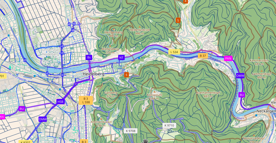
CyclOSM is a brand new bike-oriented map 1 | Leaflet | CyclOSM v0.2 | Map data © OpenStreetMap contributors
About us
- Erratum: AndiTabinas was not a scholar at SotM 2019 (as we reported in issue #479 last week). An extensive post/wiki page about this year’s scholarships will probably get published in the upcoming weeks and we will link to a more detailed update on scholars.
- We are always looking for people to help us improve our newsletter so it can get out faster, have more depth and coverage, and generally improve it for our readers, like you. Please join our team by contacting us now, it’s fun! 😉
- Manfred Reiter presented a guide on how to publish OSM news via weeklyOSM during the recent SotM in Heidelberg. So if you are a mapper, data consumer or iD programmer and feel that some kind of news deserves attention, here is a copy of the slides.
Mapping
- Valor Naram proposes to deprecate the tag
contact:phone=in favour ofphone=. So far the proposal has received mixed feedback. - Michal Fabík wants to know how to tag a homeless encampment/colony.
- The voting for jrose_aph’s proposal to simplify indoor routing with
footway=indoorhas started.
Community
- Pierre Béland mentioned his SotM 2019 presentation, Monitoring of building outlines, on the talk-ca list. This had the effect of restarting a passionate discussion about the import of buildings data published by Statistics Canada and Microsoft. Topics included which method to follow and the implications for local communities.
- Jennings Anderson reports on SotM 2019 including his own contributions: a workshop at the HOT Summit and a presentation at the main conference. The workshop concerned extracting and analysing OSM data using Amazon Athena. Some results and materials from the workshop are included in the post. His presentation concerned the influence of paid mappers on the overall OSM community.
- Fischkopp0815 asked (automatic translation) the forum for ideas on how to motivate anonymous reporters to register with OSM.
Imports
- Pierre Béland points to examples that show the limits of Microsoft’s automated building recognition.
OpenStreetMap Foundation
- SeverinGeo expressed his opinion about the checkbox that allows an OSM user to assign their contributions to the public domain (PD) when signing up to OSM. Now that he is fully aware of the pros and cons of ODbL versus PD, he would like to untick the box. This has started a long, ongoing thread indicating that the matter has been an unsolved issue for years regarding potential conflicting legal interpretations of this checkbox.
- The Local Chapters Working Group has published the minutes of its meeting on 3 September 2019.
- The Membership Working Group has updated the OSMF membership statistics.
- The minutes of the Membership Working Group meeting on 19 July 2019 have been made available.
- In the wrap-up session of State of the Map, OSM-Ireland became an official chapter of the OSMF. The agreement was signed by Dermot McCarthy for OSM-Ireland and board members of OSMF.
Events
- Adrien Pavie liked the wrapping his gift from SotM 2019 came in so much, that he framed it and hung it on the wall.
- On October 12, 2019 the mapathon Missing Maps will be held (automatic translation) for the first time in Russia. It is organised by Doctors Without Borders in conjunction with the «Greenhouse of social technologies». Don’t forget to register (automatic translation)!
- Suchith Anand announced that videos of this year’s FOSS4G Conference in Bucharest are now available.
- Stefan Keller informed us (automatic translation) that OSM will be represented together with Wikidata in a session at this year’s Swiss open data conference DINAcon on 18 October in Bern.
Humanitarian OSM
- The Climate Centre of the Red Cross and Red Crescent reports that climate action was a central theme of the HOT summit this year.
- If you did not have the chance to attend this year’s HOT summit, you can view the recorded sessions on YouTube.
- HOT continues its microgrant programme, originally started in 2017, and announced Microgrants 2020. OSM-focused organisations in lower- or middle-income countries can apply now for grants to fund mapping-related costs.
- The Kitum project is going to construct the Citizen Digital Map (automatic translation) of the National Emergency Response Drill convened by the National Unit for Disaster Risk Management — UNGRD in Colombia.
Maps
- cq94 shares a tweet pointing to the map of Seveso sites (industrial establishments linked to handling, manufacturing, using or storing dangerous substances) with «high» risk in France. He also shares the link to the data source.
- [1] CyclOSM is a brand new bike-oriented map based on OpenStreetMap data. The goal is to provide a beautiful and practical map for cyclists, regardless of their habits or abilities. A global server is available at https:/www.cyclosm.org supported by OSM-France
- If you ever wanted to know where all the witches (well, accused witches, to be precise) lived in Scotland, here’s a map that can help you with that.
switch2OSM
- Thomas Skowron is pleased that Zeit Online uses OSM data, but criticises that he cannot find a correct attribution anywhere. The great stickers that were distributed at this year’s SotM unfortunately only work with analog maps.
- The airport finder OurAirports now uses OSM and Esri satellite images instead of Google Maps, as the developers report on Twitter.
Open Data
- OpenStreetMap Belgium blogged about the importance of street-level imagery and gives a short overview about the situation in Belgium and current trends.
Software
- Guillaume Rischard reminds us to use http instead of https for connections to JOSM as https support will probably be dropped. He points to the World Wide Web Consortium specifications for trusted connections.
- Yuichiro (User nissyyu) announced
 the publication of mapcompare.jp. Up to 8 maps can be displayed simultaneously for Japanese mappers. This launch was also announced by Toshikazu at the LT session of SotM 2019.
 the publication of
Did you know …
- … of OsmInEdit, the web editor for mapping building interiors? The developer, Adrien Pavie, presented the web editor at the SotM and asked for help with development.
- … how to set up (automatic translation) an address search by coordinates?
- … how many edits Maps.Me users have made in OSM through the built-in editor? Their blog says that it’s more than 3.1 million.
OSM in the media
- Mark Altaweel has published, on the site GIS Lounge, an article with the name: Community Involvement in OpenStreetMap.
- Ciarán Staunton, of the Irish local chapter of the OSM Foundation, passionately advocated that basic land-use data should be made available to the OpenStreetMap community. The letter was in response to an article by Sylvia Thompson, in The Irish Times, entitled «Ireland needs more detailed land-use maps«.
Other “geo” things
- Problems with automated mapping are not just for Microsoft and their AI-supported recognition of building footprints. Google seems to have issues as well.
- GIS Geography published a list of the best free GIS data sources of 2019. Of course OSM made it into the list, too.
- The speakers for URISA’s Caribbean GIS Conference 2019 have been announced.
- The winners of MonoCarto 2019 have been announced. The competition, formerly known as Monochrome Mapping Competition, recognises the best maps made using one colour and its shades.
- pocketnavigation.de tested (automatic translation) the new generation of the Spanish cycling and hiking navigation system TwoNav Trail 2. Compared to its predecessor it has more buttons, it can connect to more satellites and it is more environmentally friendly.
- If you are a fantasy author and don’t want to create your own world you can just use the Procedural Fantasy Map Generator. If you’re not, it is still an interesting gimmick that creates different layers of information that are all customisable.
- Last week we mentioned the «Royal Society for Preservation of Boring Grid Squares». It turns out that there is a long and august history of such geographical minutiae in the UK. The first written reference we can find is a letter in volume 10 of The Angry Corrie, a hillwalking fanzine. Follow-up articles appeared in volumes 12, and 14, under the byline «White Holes».
- Rodolfo De Guzman has published, on the news site techinasia.com, an article about how they created a model for estimating property values in Singapore that uses OpenStreetMap data as a basis.
Upcoming Events
| Where | What | When | Country |
|---|---|---|---|
| Nantes | Village des sciences à Centrale Nantes (Fête de la science) | 2019-10-04-2019-10-05 |  |
| Fujisawa | 湘南マッピングパーティ | 2019-10-05 |  |
| Kinshasa | Rencontre OSM Kinshasa | 2019-10-05 |  |
| Ballaghadereen | Map Ballaghadereen | 2019-10-05 |  |
| Nantes | Village des sciences au Dix (Fête de la science) | 2019-10-06 | |
| Budapest | OSM Hungary Meetup reboot | 2019-10-07 |  |
| Lyon | Rencontre mensuelle pour tous | 2019-10-08 | |
| Munich | Münchner Stammtisch | 2019-10-08 |  |
| Salt Lake City | SLC Mappy Hour | 2019-10-08 |  |
| Hamburg | Hamburger Mappertreffen | 2019-10-08 | |
| Cologne | Köln Stammtisch | 2019-10-09 | |
| Arlon | Espace public numérique d’Arlon — Formation Consulter OpenStreetMap | 2019-10-09 |  |
| Wuppertal | OSM-Treffen Wuppertaler Stammtisch im Hutmacher 18 Uhr | 2019-10-09 | |
| San José | Civic Hack & Map Night | 2019-10-10 | |
| Nantes | Réunion mensuelle | 2019-10-10 | |
| Bochum | Mappertreffen | 2019-10-10 | |
| Berlin | 136. Berlin-Brandenburg Stammtisch | 2019-10-11 | |
| Zurich | 110. Zürcher Stammtisch | 2019-10-11 |  |
| Grenoble | Village des sciences sur le campus de l’UGA [1] | 2019-10-11-2019-10-12 | |
| Pilsen | Missing maps Hackathon Pilsen / Hackathon s Lékaři bez hranic | 2019-10-11-2019-10-13 |  |
| Berlin | Berlin Hack Weekend Oktober 2019 | 2019-10-12-2019-10-13 | |
| Greater Manchester | Joy Diversion 8 | 2019-10-12 |  |
| Santa Fe | State of the Map Argentina 2019 | 2019-10-12 |  |
| Bordeaux | Réunion mensuelle | 2019-10-14 | |
| Grenoble | Rencontre mensuelle | 2019-10-14 | |
| Taipei | OSM x Wikidata #9 | 2019-10-14 |  |
| Cologne Bonn Airport | Bonner Stammtisch | 2019-10-15 | |
| Lüneburg | Lüneburger Mappertreffen | 2019-10-15 | |
| Arlon | Espace public numérique d’Arlon — Formation Contribuer à OpenStreetMap | 2019-10-16 | |
| Berlin | Missing Maps Mapathon — Putting the Wolds’s Vulnerable People on the Map | 2019-10-17 | |
| Karlsruhe | Karlsruhe Hack Weekend | 2019-10-19-2019-10-20 | |
| Nottingham | Nottingham pub meetup | 2019-10-22 | |
| Žilina | Missing Maps Mapathon Žilina #6 | 2019-10-22 |  |
| Arlon | Espace public numérique d’Arlon — Formation Les itinéraires balisés et OpenStreetMap | 2019-10-23 | |
| Lübeck | Lübecker Mappertreffen | 2019-10-24 | |
| Prizren | State of the Map Southeast Europe | 2019-10-25-2019-10-27 |  |
| Dhaka | State of the Map Asia 2019 | 2019-11-01-2019-11-02 |  |
| Brno | State of the Map CZ+SK 2019 | 2019-11-02-2019-11-03 | |
| Wellington | FOSS4G SotM Oceania 2019 | 2019-11-12-2019-11-15 |  |
| Grand-Bassam | State of the Map Africa 2019 | 2019-11-22-2019-11-24 |  |
| Cape Town | State of the Map 2020 | 2020-07-03-2020-07-05 |  |
Note: If you like to see your event here, please put it into the calendar. Only data which is there, will appear in weeklyOSM. Please check your event in our public calendar preview and correct it, where appropriate.
This weeklyOSM was produced by Nakaner, Polyglot, Rogehm, SK53, SeverinGeo, Silka123, SunCobalt, TheSwavu, YoViajo, derFred, doktorpixel14, geologist, jinalfoflia, anonymus.