20/03/2025-26/03/2025
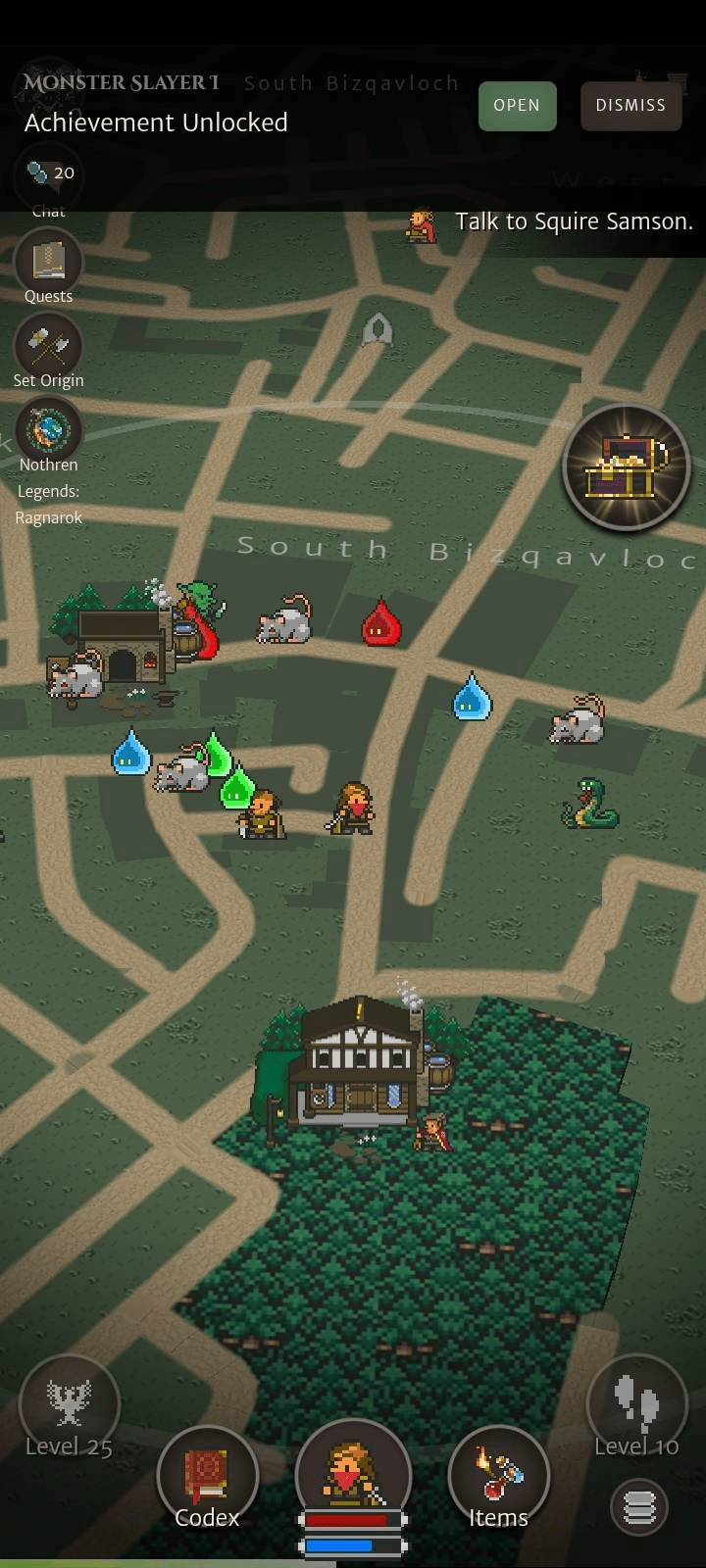
Orna – a GPS-based mobile role-playing game [1] | Image © Orna | Map data © OpenStreetMap Contributors
Community
- Bastian Greshake Tzovaras recounted his experience of contributing to MapComplete software by adding a wayside shrines layer. These small roadside altars, dedicated to saints or folk deities, serve as places of prayer and remembrance. They range from simple enclosures to elaborate sites filled with offerings.
- Using an old address book from 1910, Benjamin_K has mapped the hotels of Berlin in OpenHistoricalMap then analysed their spatial distribution.
- While working on a custom web map style that displays walking and cycling route names, Andy Townsend discovered that some hiking route names function more as descriptions rather than actual names.
- Andy Townsend shared a guide on using the JOSM validator to identify errors in OSM relations.
- DoudouOSM observed that some OpenStreetMap contributors meticulously map individual farmland parcels, revealing agricultural patterns that reflect historical practices, local geography, and technological influences. These patterns, visible from satellite imagery, range from precise geometric layouts to intricate mosaic-like formations.
- With Vietnam planning to cut its number of provinces in half as a cost-saving measure, Eugine Alvin Villar couldn’t help but note that this could become the next major mapping project for the Vietnamese OpenStreetMap community.
- The Latin American and Caribbean Open Mapping Hub held
 ►
► a workshop on OpenStreetMap and tools such as Mapillary, Organic Maps, and uMap for faculty members at Tecnológico de Monterrey, Mexico. At the end of the three-day workshop, social impact projects based on collaborative mapping were designed.
Imports
- Mathias_ADAV outlined
 ► the process of importing free-floating bike and e-scooter parking areas into OpenStreetMap, using open data released by the Métropole Européenne de Lille in July 2024.
Local chapter news
- OpenStreetMap US has published its March 2025 newsletter. There is news of the State of the Map US and much more!
Events
- The call for participation at the State of the Map 2025, set to take place in Manila, Philippines, from 3 to 5 October, is now open. The programme committee is inviting submissions for talks, workshops, and panels, offering participants a platform to share their work and engage with the global OpenStreetMap community.
- Falcius tooted
 a report on the OpenStreetMap booth
  during the first day of Chemnitz Linux Days. The booth remained open on the second day, accompanied by a scheduled presentation ► titled ‘OpenStreetMap is (Not) Just a Map’, which showcased a selection of thematic maps created using OpenStreetMap data, alongside entertaining anecdotes about the project.
 - OpenStreetMap Indonesia organised
 a mapping talk series titled ‘Improving Data Quality of Road Mapping’. The session featured M. Iqnaul Haq, Maps Ops Manager at GoTo Group, who discussed the crucial role of OpenStreetMap data in optimising route quality to enhance the operational efficiency of Gojek, an Indonesian technology company providing ride-hailing, food delivery, and logistics services.
 - The official lobster of the State of the Map US 2025 informed us that the poster session application deadline has been extended to Friday 18 April at 12:00pm EDT! Show your neat maps, personal projects, OSM research, and more.
Education
- Raquel Dezidério Souto has written a short guide showing how to map trees in OpenStreetMap with MapComplete and visualise them in three different ways (with Panoramax, overpass turbo, or uMap). This guide will serve as support material for the field mapping activities that will take place as part of Green Open Data Day 2025 or for general instructions.
- In response to a question from tlohde seeking recommendations for a web mapping tutorial/course (we reported earlier), Stefan Keller recommended two learning resources: ‘Publishing Maps on the Web‘ ► and ‘OpenStreetMap Resources for Web Developers‘.
OSM research
- HeiGIT reported that Knoblauch et al. have published a paper that underscores the critical importance of integrating vector ecology and human behaviour into advanced disease modelling frameworks. A part of the GeoEPI project, the analysis integrates knowledge of Aedes mosquito biting behaviour with human movement patterns to significantly improve inferences about urban dengue dynamics.
- Accurate road surface information is crucial for emergency response and route planning. But OpenStreetMap has comprehensive surface attributes for only 30–40% of the roads worldwide.
Using state-of-the-art GeoAI methods, HeiGIT has created an openly available worldwide dataset on road surface types. A new paper presented the methods behind the dataset.
Humanitarian OSM
- Séverin Ménard tooted that OpenStreetMap France has launched a humanitarian mapping initiative to assess building damage in Mayotte, a French overseas department, following Cyclone Chido, a tropical cyclone that struck Southeast Africa in December 2024. Utilising post-disaster satellite imagery from Copernicus, the project has already covered Mamoudzou, Tsingoni, Bandraboua, and M’Tsamboro. The latest focus is Acoua, located in the northwest of Grande-Terre, Mayotte.
Maps
- LordGarySugar has created a uMap that shows pins for house names in the United Kingdom coloured by their total occurrence count from Taginfo GB.
- Frederik Ramm announced that Geofabrik is now hosting its own version of the original ‘ÖPNVKarte’, rebranded as the ‘Public Transport Map’ for international users. The company has also approached the OpenStreetMap operations team to recommend reinstating the map on OpenStreetMap.org, which had long featured ÖPNVKarte before its recent removal due to operational concerns.
OSM in action
- [1] Orna, a location-based mobile role-playing game, utilises OpenStreetMap data to integrate real-world locations into gameplay. The game enhances players’ surroundings with virtual elements such as monsters and dungeons, with in-game positioning directly tied to their real-world location.
- The Ministry of Public Works and Housing of the Republic of Indonesia has launched a National Road and Bridge Condition Map (Peta Kondisi Jalan), utilising OpenStreetMap data to assist travellers during the annual Mudik season. This mass exodus sees millions of urban migrants returning to their hometowns ahead of Lebaran (Eid al-Fitr). The initiative aims to provide infrastructure updates, ensuring smoother and safer journeys for holiday travellers.
Software
- OpenHistoricalMap has released a renderer update that significantly improves performance by reducing vector tile sizes by 88% on average and as much as 96% in areas with dense historical boundary coverage.
- ohsome-planet is a new software library, available on GitHub, that facilitates the transformation of raw OpenStreetMap history data into the GeoParquet format, making it more accessible and efficient for spatial data analysis. With ohsome-planet, HeiGIT is making a big step toward the development of ohsome 2.0.
Programming
David de la Iglesia Castro, from Mozilla AI, revealed that their team had developed AI-driven object detection and image segmentation models to map features in OpenStreetMap. As a test, he used a free Google Colab GPU to detect hundreds of swimming pools around his hometown, completing the process in about an hour.
- In response to mounting (1, 2, 3) criticism, the development team has disabled the hosted demonstration and removed the upload functionality from their code, replacing it with a simple URL redirect to the editor. Acknowledging concerns over low-quality AI-generated contributions to OpenStreetMap, the team has also pledged to erase all previously submitted AI-assisted edits. In a statement, they assured the community that they are taking these steps to address the backlash and uphold mapping integrity.
- To mark World Water Day, observed on Saturday 22 March, Carto Cité developed ► some Overpass queries that take advantage of the OSM data model describing watercourses.
- Fabio Manganiello is currently working on ‘GPSTracker’, a self-hosted solution designed as an alternative to Google Maps Timeline.
Releases
- NeatNit just submitted a pull request addressing a longstanding issue on the OpenStreetMap website, where bidirectional text was not displayed correctly. While further improvements, such as fixing diary entries, are still needed, the update significantly improves the readability of changeset comments, which have been particularly challenging for right-to-left language users. Previously, users had to insert unnecessary line breaks to prevent text from becoming unreadable.
- Version 8.4.1 of GRASS contains more than 80 changes compared to version 8.4.0. This new minor release includes important fixes and improvements to the GRASS tools, libraries and the graphical user interface, making it more stable and robust for your daily work. Most importantly, since the 8.4.0 release, the Python API, command line, and graphical user interface are using project instead of location for the main component of the data hierarchy while maintaining backward compatibility.
- OSRM v6.0-rc1, an open-source routing engine built in C++ for use with OpenStreetMap data, has been released. The latest version includes performance improvements, enhanced algorithm efficiency, and several new features.
Did you know that …
- … that OSM Fukushima regularly discusses every Japanese edition of weeklyOSM on YouTube? Would you also like to contribute to the success of OpenStreetMap? Then consider creating a YouTube channel in your language as well.
- … SmallTownUSA, an automated bot on the en.osm.town Mastodon server, toots daily updates featuring US towns, with populations under 1000, that are currently under-mapped in OSM?
 every Japanese edition of weeklyOSM on YouTube? Would you also like to contribute to the success of OpenStreetMap? Then consider creating a YouTube channel in your language as well.
OSM in the media
- Beate Meierfrankenfeld discussed ►, in a podcast, how maps shape our world with Daniel Eschkötter, cultural and media scientist at the University of Bielefeld, Ute Schneider, historian at the University of Duisburg-Essen, and Jochen Topf, a software developer and author active in OpenStreetMap.
Other “geo” things
- HeiGIT noted that Anne Schauss and Melanie Eckle-Elze participated in the German Conference on Disaster Risk Reduction (Fachtagung Katastrophenvorsorge), held on 26 and 27 March. The event brought together experts to discuss the latest developments, challenges, and opportunities in disaster risk reduction, particularly in the context of climate change.
- François Savatier, of Pour La Science, reported that archaeologists have discovered 14,000-year-old carvings in the Ségognole shelter, located in the École River valley, about 60 km south of Paris. The engravings appear to depict a miniature map of the local river network, providing unexpected evidence of the cartographic knowledge possessed by Upper Paleolithic hunter-gatherers.
- Business Wire reported that tech company Bending Spoons has completed its acquisition of Komoot, the Germany-based route-planning platform popular among adventurers and outdoor enthusiasts. However, the acquisition has raised concerns, with Ray Maker among those questioning Bending Spoons’ track record with previous acquisitions such as Evernote, WeTransfer, and Meetup. As uncertainty looms, users and observers worry about the potential changes to Komoot’s quality and overall user experience under its new ownership.
- The Geological Service of Europe Union mantains the EGDI, a powerful and easy-to-use Web map application for visualising and querying spatial information through interactive maps, including various resources for further data analysis. This application has OpenStreetMap as its base layer and users can add layers from all the geoscientific topics EGDI covers or load a layer via a WMS address.
- Following President Donald Trump’s decree renaming the Gulf of Mexico to the Gulf of America, German Google Maps users have launched an edit war over the names of local bodies of water, Spiegel reported ►. By creating new points of interest, users can mark unofficial landmarks, which others can then view, rate, and comment on. In some cases, these new names have also sparked minor local patriotic disputes.
- Murlidhar Mohol, India’s Minister of State for Civil Aviation, announced that multiple airlines have reported instances of GNSS interference affecting aircraft operating in and around the Amritsar and Jammu regions, which lie along India’s border with Pakistan.
Stefan Krempl, from Heise, reported that the German Aerospace Centre, in collaboration with European research institutions, authorities, and industry partners, has developed Ranging Mode, a terrestrial navigation system designed as an alternative to satellite-based solutions.
- R-Mode utilises existing national maritime infrastructure, operating on medium wave and very high frequency radio signals, to provide a cost-effective backup navigation service that enables ships to determine their position without relying on satellite-based systems.
- Over the past seven years, an R-Mode test field with eight transmitters has been established, covering about 800 km from Helgoland to Stockholm. In 2025, it will expand to include Finland and Estonia.
Upcoming Events
| Where | What | Online | When | Country |
|---|---|---|---|---|
| Green Open Data Day (ou Dia Verde dos Dados Abertos) | 2025-03-31 – 2025-04-01 | |||
| Seropédica | Green Open Data Day 2025 (ou Dia Verde dos Dados Abertos 2025) | 2025-03-31 – 2025-04-01 |  | |
| Saint-Étienne | Rencontre Saint-Étienne et sud Loire | 2025-03-31 |  | |
| Santa Maria Maior | Missing Maps Lisbon Mapathon with MSF | 2025-04-01 |  | |
| Salzburg | OSM Treffen Salzburg | 2025-04-01 |  | |
| Missing Maps London: (Online) Mapathon [eng] | 2025-04-01 | |||
| San Jose | South Bay Map Night | ✓ | 2025-04-02 |  |
| Stuttgart | Stuttgarter OpenStreetMap-Treffen | 2025-04-02 |  | |
| OSMF Engineering Working Group meeting | 2025-04-04 | |||
| City of Canning | Social Mapping Saturday: Rossmoyne | 2025-04-05 |  | |
| OSMF Affiliation Focus Group Discussion: Thematic and non-geographical groups | 2025-04-05 | |||
| New Orleans | A Synesthete’s Atlas: Cartographic Improvisations between Eric Theise and Carl Stone | 2025-04-06 | | |
| Delhi | 15th OSM Delhi Mapping Party (Online) | 2025-04-06 |  | |
| Salt Lake City | OSM Utah Monthly Map Night | 2025-04-09 | | |
| Hamburg | Hamburger Mappertreffen | 2025-04-08 | | |
| München | Münchner OSM-Treffen | 2025-04-08 | | |
| Bern | Berner OpenStreetMap-Znacht | 2025-04-08 |  | |
| Zürich | Missing Maps Zürich Mapathon | 2025-04-09 | | |
| Camerino | OpenStreetMap: Mapping & Hiking | 2025-04-10 |  | |
| Bochum | Bochumer OSM-Treffen | 2025-04-10 | | |
| København | OSMmapperCPH | 2025-04-13 |  | |
| Delhi | 15th OSM Delhi Mapping Party | 2025-04-13 | | |
| 中正區 | OpenStreetMap x Wikidata Taipei #75 | 2025-04-14 |  |
Note:
If you like to see your event here, please put it into the OSM calendar. Only data which is there, will appear in weeklyOSM.
This weeklyOSM was produced by Elizabete, Raquel Dezidério Souto, Strubbl, TheSwavu, barefootstache, derFred, miurahr.
We welcome link suggestions for the next issue via this form and look forward to your contributions.