13/07/2021-19/07/2021
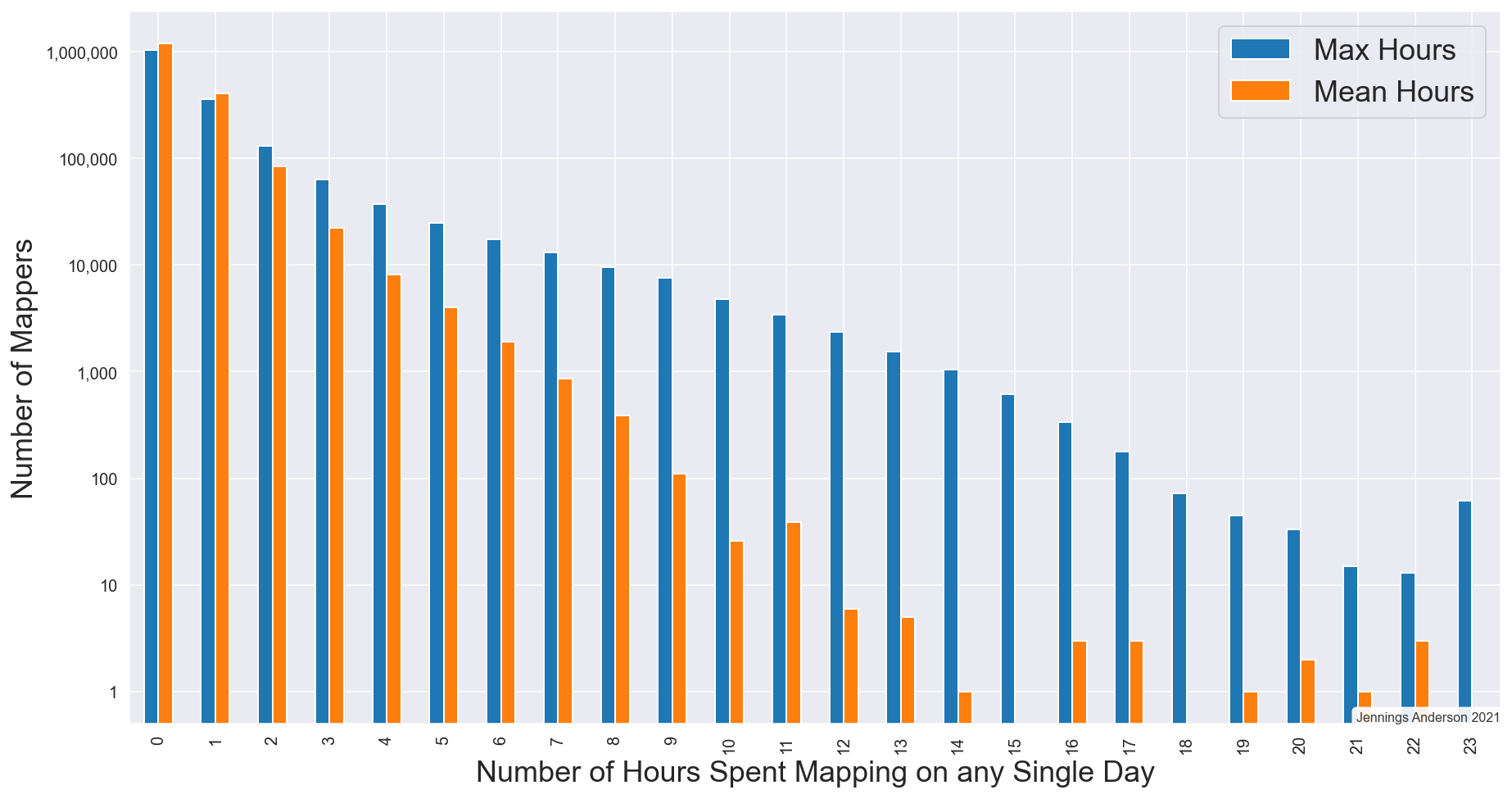
How many hours do you map? [1] | © Jennings Anderson |
Mapping
- Mappers in the German OSM Forum
 > and on the Talk-de mailing list > discussed how to deal with the floods in Western Germany. Damaged roads which will stay impassible for a longer time should be tagged as under construction or demolished. Buildings should not be edited/deleted for the time being. Road closures for a relatively short time and closures of passable roads should not be mapped.
 - Mark Altaweel took a look at map vandalism in OpenStreetMap. They describe what map vandalism is and what strategies are used to fix it or prevent it from happening.
- If you map in Washington state it would be worthwhile reading jake-low’s diary entry on how to use the Department of Natural Resources LiDAR in iD.
- MKnight questioned > some of the reasons given for voting against the
leisure=bathing_placeproposal (we reported earlier). - Philippe Lacour noted that there are now more objects in OpenStreetMap than people on the planet.
- portalaventura asked > why Apple editors feel the need to bend streets.
- User syntex shared a progress update on his quest to replace all the mapped buildings in Warsaw with outlines from a government dataset, BDOT10k.
- Requests have been made for comments on the following proposals:
cultivated=no/semi/fullyto add sub-tags tonatural=scrubthat could be used to further refine these bushy areas based on objective criteria.tennis=wallto map tennis training walls, used to practise tennis shots without the need for an opponent.headlight=*for tagging when vehicle headlights must be used.
 >
> 
 >
> Community
- How many hours a day do you map? Jennings Anderson investigated how much time mappers spend on the task and concluded that while some mappers might only ever make a single edit to a map, there are plenty of ardent, dedicated editors that map like it’s their job – and for some of these mappers it might be, but definitely not all.
- Nama wrote, as Regional Director of HOT, about the foundation and activities of the (Mobile) Open Mapping Hub Asia Pacifik.
OpenStreetMap Foundation
- To reduce mass downloads from
tile.openstreetmap.org, in violation of the tile usage policy, the Operations Working Group has put an automatic block that filters the 0.001% users who cause 13% of the load.
Events
- DeBigC reviewed the format of this year’s State of the Map. They concluded that, on balance, the interesting talk content and speakers outshone the weaker points.
- Paul Norman blogged a version of their SotM talk on the OpenStreetMap Standard Layer and who’s using it.
- The proceedings of the Academic Track at State of the Map 2021 have been published.
- Ilya Zverev made > a HotWashUp on the SotM, mainly impressions and about his own activity.
 >
> Education
- AngocA answered > JuanMelo’s question ‘how do I improve the map of Colombia?’.
 >
> Humanitarian OSM
- HOT has opened applications for their Data Quality Internship. It is a three-month, full-time, paid opportunity. HOT is looking to fill 20 positions, and women, nationals of developing countries, and members of other under-represented groups are strongly encouraged to apply. Applications close Sunday 15 August.
- The HOT Disaster Services Team has launched a new landing page featuring a detailed projection of the task areas they are focused on mapping. The new map display is powered by Kontur.
- HOT has opened the call for proposals for their 2021 Summit. The theme of this year’s summit is ‘The Evolution of Local Humanitarian Open Mapping Ecosystems: Understanding Community, Collaboration, and Contribution’. See the list of suggested formats and submit your proposals for sessions here by Tuesday 10 August.
Maps
- team2019alpaca is excited to have made a new map for visitors to the Steep Street Domain in Lawrence (New Zealand).
Software
- Darkshredder gave an update, illustrated with screenshots, about his Google Summer of Code Project. The Nominatim Feedback Reporter will allow users to submit OpenStreetMap search (Nominatim) errors. These can then be added as test cases by the developers.
Releases
- OsmAnd 4.0 (iOS) has been released. It adds new features such as snapping recorded routes to roads to enable better navigation, exporting and importing of settings, data, and maps between Android and iOS devices, and fixing freezing issues on CarPlay.
Other “geo” things
- Liberty caps – or Psilocybe semilanceata – are psilocybin-containing mushrooms that grow naturally in many parts of the world. Are you interested in finding some of them in your neighbourhood? Just have a look to this ‘Magic Mushroom Map’.
- prawo.pl reports > that 10 new settlements in Poland are proposed to gain city status on 1 January, 2022. Administrative boundaries of some municipalities will change as well. In the past year,
place=citywas promptly added by Polish mappers sometimes even before 1 January, however in many cases boundaries had to wait for official registers to catch up. - Rush hour in the Netherlands!
- A digitally rendered map, derived from a vintage geological map of Australia combined with Digital Elevation Data (DEM), created by 4DMAPART, is making the rounds on Twitter.
- Two major NGOs, dedicated to preserving Scottish mountains, expressed their concern about inappropriate and potentially dangerous routes displayed on Google Maps.
- In their engineering blog Lyft described how their mobile apps cache map data (presumably OSM) to improve positioning, perform map matching, and display speed limits to drivers.
- In an essay, Meaghen Brown explains how maps are inherently inaccurate and rather than having blind faith in them, users should be cautious of the data sources.
 >
> Upcoming Events
| Where | What | Online | When | Country |
|---|---|---|---|---|
| OSM Africa Monthly Mapathon: Map Nigeria | 2021-07-02 – 2021-08-02 | |||
| Virtueel treffen OpenStreetMap NL | 2021-07-24 | |||
| Bogotá Distrito Capital | Resolver notas de Bogotá creadas en OpenStreetMap | 2021-07-24 |  | |
| Budapest | Hekkezés-fagyizás a Római parton, séta a zöldben (személyes!) | 2021-07-26 |  | |
| Bremen | Bremer Mappertreffen (Online) | ✓ | 2021-07-26 |  |
| Ville de Bruxelles – Stad Brussel | Virtual OpenStreetMap Belgium meeting | ✓ | 2021-07-27 |  |
| Aubière | Rencontre OpenStreetMap Clermont | 2021-07-28 |  | |
| Düsseldorf | Düsseldorfer OSM-Treffen (online) | 2021-07-28 | | |
| Zürich | Missing Maps Zürich Mapathon | 2021-07-28 |  | |
| [Online] OpenStreetMap Foundation board of Directors – public meeting | 2021-07-30 | |||
| 臺北市 | COSCUP 2021 OpenStreetMap x Wikidata 開放內容議程軌 | ✓ | 2021-07-31 |  |
| Ogresgala pagasts | Ogresgala kartēšanas pasākums | 2021-07-31 |  | |
| City of Westminster | Missing Maps London Mapathon | 2021-08-03 |  | |
| Landau an der Isar | Virtuelles Niederbayern-Treffen | ✓ | 2021-08-03 | |
| Nordrhein-Westfalen | OSM-Treffen Bochum | 2021-08-05 | | |
| OSM Africa Monthly Mapathon: Map Tanzania | 2021-08-06 | |||
| 臺北市 | OpenStreetMap x Wikidata Taipei #31 | 2021-08-09 | | |
| Zürich | OSM-Treffen Zürich | 2021-08-11 | | |
| OpenStreetMap Michigan Meetup | 2021-08-13 |
Note:
If you like to see your event here, please put it into the OSM calendar. Only data which is there, will appear in weeklyOSM.
This weeklyOSM was produced by Climate_Ben, Nordpfeil, RicoElectrico, SK53, TheSwavu, derFred, s8321414.