13/09/2022-19/09/2022
Come usare Every Door [1] | © Ilya Zverik | map data © OpenStreetMap contributors
Chi siamo
- Siamo sempre alla ricerca di persone che ci aiutino a migliorare il nostro blog in modo da renderlo più veloce, più approfondito e in generale più utile per i nostri lettori, come te! Unisciti al nostro team.
Mappatura
- La città francese di Rennes annuncia
 > tre mapping party durante i quali i cittadini saranno accompagnati nell’aggiunta di negozi su OpenStreetMap.
 - Pieter Vander ha annunciato > che MapComplete è ora in grado di rilevare automaticamente le specie di alberi utilizzando l’API di PlantNet.org, rendendo più facile collegare un albero alla sua specie corretta durante la mappatura della posizione degli alberi su OpenStreetMap.
- Sono stati richiesti commenti sulle seguenti proposte:
highway=scramble > per indicare che un sentiero deve essere percorso con le mani.site_type=defensive_settlement > un nuovo sottotipo per i siti archeologici di un insediamento civile con strutture difensive (mura, fossati, recinzioni ecc.) per tenere lontani i nemici.
- Le votazioni sulle seguenti proposte si sono chiuse:
crossing:markings > , per dichiarare l’esistenza e lo stile delle strisce pedonali, è stata approvata con 29 voti favorevoli, 1 voto contrario e 3 astensioni.
- Sono in corso le votazioni per le seguenti proposte:
- Chiarire la definizione dei cartellini dimensionali > utilizzati sulle banchine di carico, fino a mercoledì 28 settembre.
- Chiarire la definizione dei cartellini dimensionali
 >
> 
 >
> Comunità
- Mannivu ha scritto un diario su come caricare foto su Wikimedia Commons, creare un elemento Wikidata, creare una categoria su Wikimedia Commons, collegare elemento Wikidata e categoria Commons, e inserire questi dati su OSM.
- Martijn van Exel si chiede > perché non esiste un modulo di ricerca per i diari OSM > . I commentatori spiegano come utilizzare il tuo motore di ricerca preferito.
 su come caricare foto su Wikimedia Commons, creare un elemento Wikidata, creare una categoria su Wikimedia Commons, collegare elemento Wikidata e categoria Commons, e inserire questi dati su OSM.
Eventi
- Katja Haferkorn ha annunciato > che la riunione di lavoro sul tema dell’etichettatura indoor di OpenStreetMap > si terrà a ottobre 2022.
- Alcuni dati > statistici sull’ultimo SotM a Firenze.
 >
> OSM e l’azione umanitaria
- Adam Rousell riporta > che HeiGIT ha attivato il servizio di routing aperto per i disastri nella regione in risposta alle gravi inondazioni monsoniche che hanno colpito il Pakistan nelle ultime settimane. I dati vengono aggiornati ogni 10 minuti per riflettere la situazione dinamica e le infrastrutture interessate.
Mappe
- Martijn van Exel ha pubblicato > un clone open source del server di tile vintage OSM > di Illya.
switch2OSM
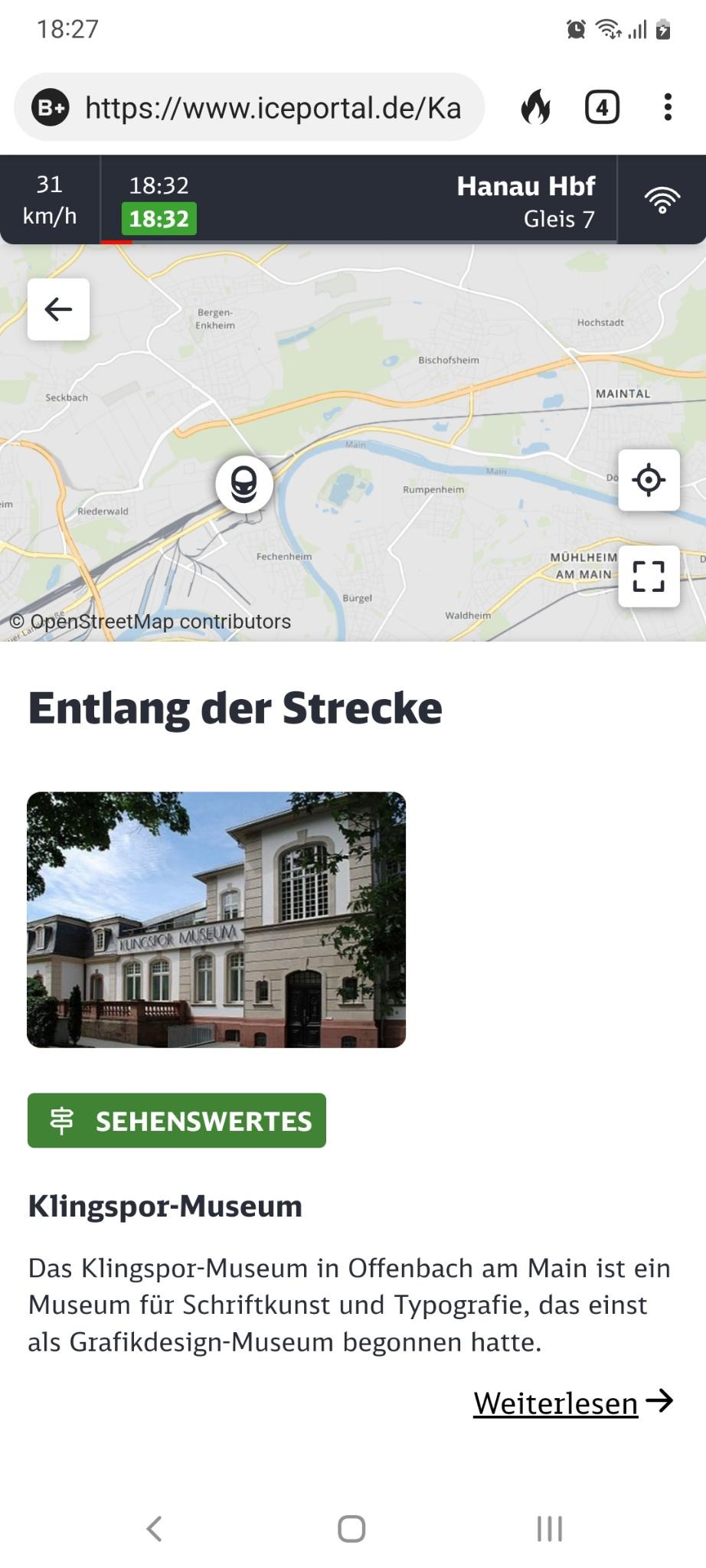
- Deutsche Bahn utilizza > OSM nel suo sistema di informazione per i passeggeri. Traccia la velocità attuale del treno, la sua posizione e il suo orario e informa il passeggero sui punti di interesse che si possono trovare lungo il percorso. Ne consigliamo l’imitazione.
Open Data
- GwenCarto ha tenuto un tutorial sul NoiseModelling > utilizzando i dati OSM.
- Lo stato di Sassonia-Anhalt, in Germania, ha pubblicato > una nuvola di punti Digital Surface Model con una risoluzione di 20 cm come OpenData (via Twitter) . La licenza > consente di utilizzare i dati per migliorare OSM.
Licenze
- Harry Wood ha pubblicato > un articolo per commemorare il 10° anniversario della Open Database License (ODbL), la licenza dei dati di OpenStreetMap. La ODbL è stata creata in risposta a diversi problemi riguardanti l’inadeguatezza della licenza CC BY-SA quando applicata ai dati cartografici.
- Andres Gomez Casanova ha pubblicato due video in spagnolo in cui spiega l’incompatibilità tra ODbL e CC-BY. Approfondiscono > un articolo del 10 aprile 2022. Ne abbiamo parlato in precedenza.
- Il problema dell’attribuzione.
- L’uso del DRM nelle opere derivate dove ODbL lo consente ma CC-BY no.
 >
> 
Software
- [1] Ilya Zverik ha pubblicato > un tutorial per l’editor di Every Door OpenStreetMap per i POI e gli ingressi insieme alla versione 2.0 di questo software pubblicata ufficialmente un mese fa. I download sono disponibili per Android e iOS. Le note di rilascio sono su Github.
- Arno Wolter, uno dei tre fondatori e amministratore delegato dell’iniziativa “Sichere Straßen”, parla > del nuovo progetto ” Gefahrenstellen.de“, che mira a mostrare a genitori e scolari percorsi scolastici sicuri e non affollati. Il progetto utilizza openrouteservice di HeiGIT come servizio di routing, a sua volta basato sui dati OSM.
- Altilunium ha rilasciato Pataddress, un clone open-source di what3words (ma con 4 parole) con un analizzatore di frequenza di parole integrato per costruire il proprio database di parole nella propria lingua.
- GraphHopper ha rilasciato > la sua sesta versione del motore di routing. L’aggiornamento offre un calcolo più rapido dei percorsi, maggiore flessibilità, istruzioni migliori e documentazione per gli sviluppatori.
- HeiGIT, l’Istituto di Heidelberg per la tecnologia della geoinformazione, descrive > la nuova funzione dell’Analizzatore di Qualità Ohsome: > l’indicatore di integrità dell’edificio. Questo indicatore utilizza variabili proxy per prevedere l’area edificabile prevista in una determinata area e confronta questa previsione con l’area edificabile attualmente mappata in OSM.
- Marcel Reinmuth riferisce > che la Open Healthcare Access Map ha raggiunto una copertura globale. La Open Healthcare Access Map utilizza OpenStreetMap, il servizio openroutes di HeiGIT e WorldPop per stimare il numero di persone che vivono entro una certa distanza da una struttura sanitaria. I dati sono disponibili anche su Humanitarian Data Exchange.
- Il team di sviluppo di RapiD di Meta ha pubblicato una “anteprima” di RapiD 2.0 alpha. Il cambiamento principale è la riscrittura del motore grafico per migliorare le prestazioni generali. Chiedono feedback tramite Github, Slack o Facebook.
- Felt ha annunciato > che Erica Fischer, la creatrice della libreria Tippecanoe, si è unita all’azienda per continuare il suo lavoro open-source. Tippecanoe è un convertitore di GeoJSON in tiles di mappe vettoriali, con un intento estetico specifico che consente di ottenere una visione indipendente dalla scala dei dati. A qualsiasi livello di zoom, la densità e la consistenza dei dati sono ancora visibili, invece di dover escludere manualmente alcune classi di dati.
Programmazione
- Il team di osm2pgsql ha appena annunciato > che il codice sorgente di osm2pgsql è stato sottoposto a un controllo di sicurezza. Nessuno dei test ha rivelato gravi problemi di sicurezza, ma gli utenti devono essere consapevoli di dover impostare correttamente un ambiente di sistema sicuro. Il team ha modificato ulteriormente il manuale per spiegare alcune importanti pratiche di sicurezza.
Rilasci
- Vespucci, l’editor per Android che permette qualsiasi tipo di editing direttamente sul dispositivo mobile, ha rilasciato la versione 18.0.0. I punti salienti sono descritti > in un post sul blog.
- Marcos Dione ha scoperto > che i file di mappe JPEG con parametro di qualità 70-80 hanno dimensioni pari o inferiori al 50% di quelle del formato PNG, adatte alle applicazioni di mappe mobili a bassa risoluzione, offline e a bassa connettività. Ha anche aggiornato i suoi osm-tile-tools per accettare il formato JPEG.
Lo sapevi che…
- Marcel Reinmuth presenta diverse mappe con informazioni sull’accesso all’aborto in Germania, create utilizzando il servizio openroutes di HeiGIT?
- … puoi trovare posti con opzioni vegetariane (
diet:vegetarian) e vegane (diet:vegan) utilizzando Veggiekarte? - … esiste una raccolta anonima di analisi > sui problemi dell’algoritmo W3W e della sua implementazione?
OSM nei media
- OpenCage collabora con il podcast MapScaping per promuovere > I progetti basati su OSM. Il progetto selezionato riceverà un messaggio promozionale di 30 secondi in un episodio del podcast e l’inclusione del logo sulla pagina principale e sull’account Twitter di MapScaping. Può partecipare qualsiasi progetto che utilizzi OpenStreetMap (strumenti, tecnologie, servizi, open source, ONG o start-up a scopo di lucro). Puoi candidarti qui fino al 15 ottobre 2022.
Altre cose “geo”
- Gli eventi associati ai riti funebri della Regina Elisabetta II sembrerebbero un motivo improbabile per una notizia geospaziale. Tuttavia, Gizmodo ha riferito > che si sono verificati alcuni strani errori nell’uso di what3words per aiutare le persone a trovare la fine della coda per vedere la bara durante la deposizione > del corpo.
Prossimi eventi
| Dove | Cosa | Online | Quando | Nazione |
|---|---|---|---|---|
| Budapest | OSM Fonó: Short editing introduction and remote help (online, live) | 2022-09-23 |  | |
| Recife | [online] First pic4review mapathon from UMBRAOSM (BR) | 2022-09-24 |  | |
| La Virgen | 5ta reunión bimestral de OSM Latinoamérica | 2022-09-24 |  | |
| Cisterna d’Asti | Incontro mapper astigiani | 2022-09-24 |  | |
| Karlsruhe | Karlsruhe Hack Weekend | 2022-09-24 – 2022-09-25 |  | |
| Gent | 2022-09-26 |  | ||
| OSMF Engineering Working Group meeting | 2022-09-26 | |||
| Arlon | Réunion des contributeurs OpenStreetMap, Arlon (Belgium) | 2022-09-26 | | |
| Derby | OSM East Midlands/Nottingham meetup | 2022-09-27 |  | |
| San Jose | South Bay Map Night | ✓ | 2022-09-28 |  |
| London | Geomob London | 2022-09-28 | | |
| Washington | OSM US Mappy Hour | ✓ | 2022-09-29 | |
| Vern-sur-Seiche | Atelier participatif « Recensement des commerces » | 2022-09-29 |  | |
| Düsseldorf | Düsseldorfer OpenStreetMap-Treffen | ✓ | 2022-09-30 | |
| Villa de Cos | Notathon en OpenStreetMap – resolvamos notas de México | 2022-10-01 |  | |
| Hacktoberfest 2022 | 2022-10-01 – 2022-10-31 | |||
| 臺北市 | OpenStreetMap x Wikidata Taipei #45 | 2022-10-03 |  | |
| London | Missing Maps London Mapathon | 2022-10-04 | | |
| Stuttgart | Stuttgarter Stammtisch | 2022-10-04 | | |
| London | London pub meet-up | 2022-10-04 | | |
| Berlin | OSM-Verkehrswende #39 (Online) | ✓ | 2022-10-04 | |
| Murray | OSM Utah Monthly Meetup | 2022-10-06 | | |
| Mannheim | Mapathon in der Moschee | 2022-10-06 | | |
| Град Крагујевац | OSM Serbia regular meetup | ✓ | 2022-10-06 |  |
| La Chapelle-des-Fougeretz | Atelier participatif « Recensement des commerces » | 2022-10-07 | | |
| Kaiserslautern | OSM Mapping Event Erfassung von Barrieren | 2022-10-08 | | |
| 京都市 | 京都!街歩き!マッピングパーティ:第32回 Re:妙心寺 | 2022-10-08 |  | |
| Polokwane Local Municipality | OSM Africa October Mapathon | ✓ | 2022-10-08 |  |
| Polokwane Local Municipality | OSM Africa October Mapathon | ✓ | 2022-10-08 | |
| Washington | MappingDC Mappy Hour | 2022-10-12 | | |
| München | Münchner OSM-Treffen | 2022-10-11 | | |
| San Jose | South Bay Map Night | ✓ | 2022-10-12 | |
| Frankfurt am Main | Arbeitstreffen Indoor OSM 2022 | 2022-10-14 – 2022-10-16 | |
Nota: Se vorresti vedere qui elencato il tuo evento, per favore inseriscilo nel calendario. Solo i dati che sono inseriti lì appariranno nel notiziario.
Questa Notiziario Settimanale OSM è stato prodotto da Lejun, Mannivu, Strubbl, TheSwavu, UNGSC_Alessia13, derFred, isoipsa, rtnf, tordans.