10/01/2023-16/01/2023
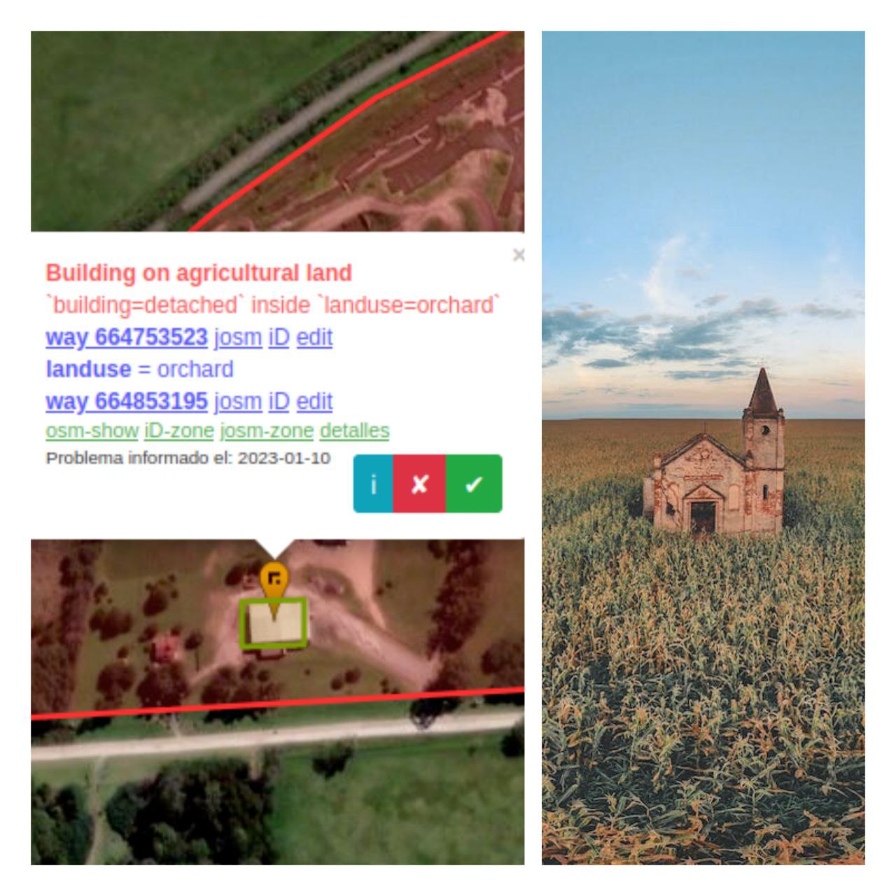
Osmose QA introduces a new check [1] | © Public Domain
Breaking news
- The next public OSMF Board meeting will be held in the online boardroom on Thursday 26 January at 13:30 UTC.
The preliminary agenda is on the Board/Minutes/2023-01 wiki page and this is also where the draft minutes will be added.The topics to be covered are:- Treasurer’s report
- Provisional 2023 budget
- Strategic plan – formal structure report
- Advisory Board – monthly update
- Monthly presentation – YouthMappers
- Guest comments or questions.
Find out on the Monthly Board Meetings wiki page how to have future board meetings automatically added to your calendar.
About us
- Do you read our blog in English?
Do you want to read the new issue two days earlier?
Do you want to help prepare weeklyOSM?
Are you a native English speaker?
Then we are looking for you!
Write us a short email to info at weeklyosm dot eu and we will let you know how you can help. - From this issue we are publishing our weeklyOSM articles under the CC0 licence instead of CC-BY-SA. You can link, cite, reuse or rephrase our articles without restrictions. Nevertheless we are of course happy if you still attribute us.
Mapping
- One culture’s profanity may be another’s street name. Meta’s #ProfanityCleanup edits triggered a discussion on Talk-GB about this topic.
- Andy Townsend (SomeoneElse) documented how he followed a path that existed only on a map and concluded that it doesn’t belong in OSM.
- Mateusz Konieczny is seeking the community’s view on the difference between
surface=fine_gravelandsurface=compacted. - Voting is underway on the proposal to extend the usage of
utility=*to apply consistently to service/industrial buildings and cabinets, until Thursday 26 January.
Community
- In the Geomob Podcast #164 Ed Freyfogle chatted with Simon Poole, OSM mapper since 2010, former chair of the OSMF, and maintainer of Vespucci, about his perspective on OpenStreetMap.
- The OpenStreetMap Ops Team gave an update on the status of the migration of the old forum content to the new OSM Community forum.
Local chapter news
- The OpenStreetMap Polska Association is
 ► proud to announce the signing of an agreement with CloudFerro, the operator of the Creodias platform to enable, but not limited to, further development of the www.openaedmap.org project.
 ►
►
Events
- @dukera, in a video, explained how Overpass can be used in geospatial intelligence.
- Edward Betts is going to talk at the upcoming FOSDEM about linking OpenStreetMap and Wikidata.
 how Overpass can be used in geospatial intelligence.
OSM research
- A paper from HeiGIT and GIScience at Heidelberg University, on improving the accuracy of OSM missing building detection in sub-Saharan Africa, was featured on the May 2022 cover of Transactions in GIS. The team proposed a novel few-shot transfer learning method (FSTL) to improve humanitarian organisations’ mapping workflows in the Global South. Further details on the approach, and its current limitations, is available on the HeiGIT site.
Licences
- Pieter Vander Vennet investigated, using Overpass, what licences MapComplete users are applying to their uploaded pictures. The vast majority are uploaded with the default licence, being CC0/public domain. Power users, though, often change the licence to CC-BY or CC-BY-SA. As a by-product of his investigation, a ranking of MapComplete’s most active users has been compiled, led by ‘legendary mapper’ Awo.
Software
- Anne-Karoline Distel spotted that Field Papers was not working (see also a Reddit thread). Ciarán (DeBigC) reported it on GitHub and, fortunately, Alan Maconchie restarted the server. However, as with other Stamen services, they are looking for others to take on support.
- James Milner found that ChatGPT is pretty good at generating GeoJSON.
- GeoDesk reported a new feature:
statsqueries. The thread includes various examples of typical queries, from the opening hours of pubs in Scotland, to the length of rivers in Colorado.
Programming
- MTRNord tooted that they have created a script to quickly build transit maps using the Cartes tool, after it was reported on weeklyOSM.
Releases
- QA tool Osmose has introduced a new check for buildings on agricultural land that appear to be too large.
Did you know …
- … there are special phrases that cause Nominatim to search for a specific
key=valuepair? - … if you mix up latitude and longitude, Alvin Bryan has some tips to remember them correctly?
OSM in the media
- Carey Davies, writing in The Great Outdoors magazine, provided in-depth analysis of recent mountain rescue incidents in the English Lake District, which were occasioned by the use of outdoor hiking apps based on OpenStreetMap data. Earlier, The Guardian and online magazine Grough had also covered this topic. It is these reports that led to SK53’s path analysis, which we reported earlier.
- Alex Roddie, quoted in The Great Outdoors article above, published his own detailed analysis of the use of OpenStreetMap by a range of outdoor hiking applications. He received a lot of feedback from experienced UK-based mountain guides on both Twitter and Mastodon.
- Netzpolitik recommended ► installing StreetComplete and other FOSS tools to rid yourself of GAFAM.
 ►
►Other “geo” things
- Google Maps has introduced a visual positioning system ‘to provide location and navigation services for users of its AR “Live View” feature’.
- Giorgia Tolfo blogged on how the Living with Machines project is digitising 19th century Ordnance Survey maps from the British Library. The work is complementary to the well-known historical maps hosted by the National Library of Scotland, as the focus is on maps not already available digitally. Living with Machines is the flagship Digital Humanities project of the Turing Institute, the UK national AI research institute.
- The American Geographical Society published its ‘Map of the week’ with the title ‘What does the land under Antarctica’s ice sheet look like?’.
- Christoph Hormann wrote about the open licensing of map designs.
- Abhishek Nagaraj and Scott Stern have written an essay on the distinctive economic properties of maps and the role that geographic information plays in economic geography.
- Astronomers also create maps. See the universe from above!
Upcoming Events
| Where | What | Online | When | Country |
|---|---|---|---|---|
| Dar es Salaam | State of the Map Tanzania | 2023-01-19 – 2023-01-21 |  | |
| Budapest | Hiking by the pipeline between Normafa-Stop Shop-Aranyvölgy | 2023-01-21 |  | |
| Toulouse | Réunion du groupe local de Toulouse | 2023-01-21 |  | |
| Downtime | 2023-01-22 | |||
| Bremen | Bremer Mappertreffen (Online) | 2023-01-23 |  | |
| OSMF Engineering Working Group meeting | 2023-01-24 | |||
| Düsseldorf | Düsseldorfer OpenStreetMap-Treffen | ✓ | 2023-01-25 | |
| [Online] OpenStreetMap Foundation board of Directors – public videomeeting | 2023-01-26 | |||
| IJmuiden | OSM Nederland bijeenkomst (online) | ✓ | 2023-01-28 |  |
| 南区 | 京都!街歩き!マッピングパーティ:第35回 六孫王神社 | 2023-01-29 |  | |
| Windsor | OSM Windsor-Essex Monthly Meetup | 2023-01-31 |  | |
| San Jose | South Bay Map Night | ✓ | 2023-02-01 |  |
| Hannover | OSM-Stammtisch Hannover | 2023-02-06 | | |
| MapRoulette Monthly Community Meeting | 2023-02-07 | |||
| Stuttgart | Stuttgarter Stammtisch | 2023-02-07 | | |
| City of Westminster | Missing Maps London Mapathon | 2023-02-07 |  | |
| Zürich | OSM-Stammtisch | 2023-02-08 |  | |
| München | Münchner OSM-Treffen | 2023-02-08 | | |
| Salt Lake City | OSM Utah Monthly Map Night | 2023-02-09 | | |
| Neufchâteau | OpenStreetMap – Réunion à Neufchâteau | 2023-02-09 |  |
Note:
If you like to see your event here, please put it into the OSM calendar. Only data which is there, will appear in weeklyOSM.
This weeklyOSM was produced by MatthiasMatthias, Nordpfeil, PierZen, SK53, Strubbl, TheSwavu, YoViajo, derFred.
We welcome link suggestions for the next issue via this form and look forward to your contributions.