16.05.–22.05.2024
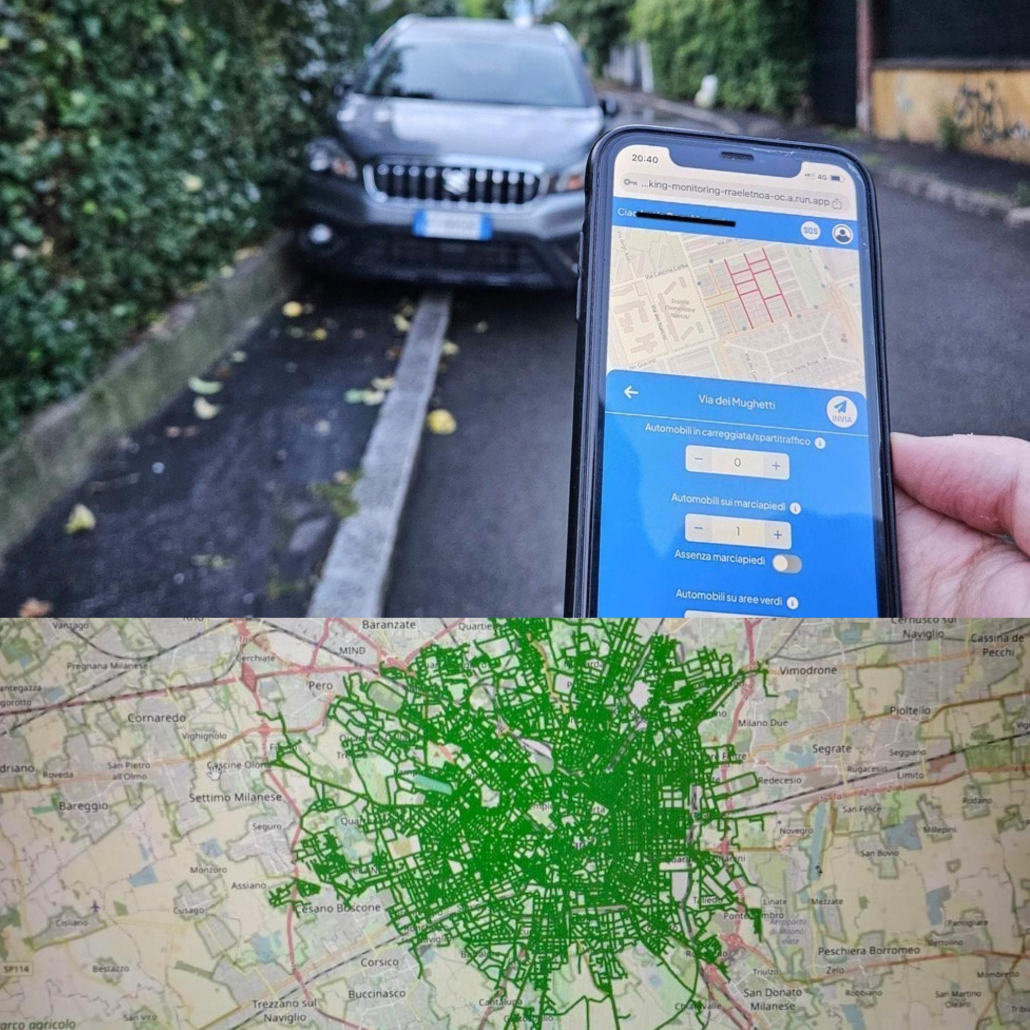
Identifikace nelegálního parkování v Milánu [1] | © saichepuoi | map data © přispěvatelé OpenStreetMap
OSM CZ
- Jeden z vandalů v OSM řádí i v centru Olomouce.
- Žádost o kontrolu budovy a jejího stavu v OSM versus RUIAN v souvislosti s nedávnou výzvou v MapRoulette.
- Dotaz od VladaC na aktuální stav bodů záchrany od Vojenských lesů a statků.
OSM SK
- Nepřesné označení problematické budovy ve výzvě MapRoulette.
- Návod pro instalaci podrobných slovenských map (freemap.sk) do chytrých hodinek Garmin.
- Informace o plánované odstávce webu freemap.sk kvůli údržbě a aktualizacím.
Mapování
- Následující návrhy na tagování vás žádají o komentáře:
- Návrh pro označení tagu
cycleway=oppositejako zastaralého. - Návrh na zavedení tagu
natural=wadipro široké ploché kanály nepravidelných toků s jasnými břehy. - Návrh pro zavedení prefixu
ordering:pro telefonní čísla sloužící jen pro objednávání přes volání nebo SMS a další rozšíření pro bližší specifikaci detailů o kontaktech.
- Návrh pro označení tagu
Komunita
- Terence Eden oslavil 1 000 sad změn v OpenStreetMap. Zamyslel se nad prošlapanou cestou, svými příspěvky a hodnotou komunity OpenStreetMap.
- A35K diskutuje o použití tagu
class:bicyclev OpenStreetMap pro označení komfortu cyklisty na silnici a vysvětluje výzvy k implementaci a úspěchy v různých regionech jako jsou německý Mnichov nebo Unterschleißheim. Dále zdůrazňuje osobní zkušenost a strategii pro tagování a mapování s pomocí tohoto klasifikačního systému. - V prvním příspěvku ze série „Nejhorší z OSM v Ghaně“ Enock4seth podrobně popsal snahy o zlepšení mapování pozemků určených k bydlení v okolí ghanské Kumasi prací na zastaralých nebo nepřesných datech. Při práci používá nástroj JOSM a spolupracuje s lokálními mappery a zdůrazňuje důležitost přesných a nekonfliktních příspěvků pro ty, co mapují v OpenStreetMap na dálku.
- GrumpyGorilla popisuje metodu vyhledávání nefunkčních webových stránek v datech OpenStreetMap pomocí skriptu v jazyce Python, který se dotazuje na uzly s webovými stránkami a kontroluje chyby. To umožňuje uživatelům identifikovat a ověřit zastaralé nebo nefunkční odkazy osobně i z křesla.
- Juminet aktualizovala
 ► stav dokončení mapování adres v belgickém Valonsku do OpenStreetMap a všímá si výrazného zlepšení z 64.4 % v září 2022 na 73.2 % v květnu 2024. Porovnává data OSM a databázi ICAR a vyzdvihuje okrsky s největším zlepšením.
 - Nadaraj Saranya sdílí své zkušenosti dobrovolnické ambasadorky členské kampaně Nadace OpenStreetMap v roce 2024. Speciálně vyzdvihuje úsilí zvýšit globální diverzitu speciálně v regionech s malým zastoupením. Zdůrazňuje také možnosti vzdělávání a zapojení komunity, které díky kampani získala.
- OSMChina oznámila projekt OSPP 2024 pro vytvoření uživatelsky přívětivého multiplatformního editoru dat o veřejné dopravě pro OpenStreetMap, který by měl využívat moderní technologie pro zjednodušení vytváření tras a jejich správu s cílem omezit čas potřebný pro editaci a námahu pro mappery (informovali jsme dříve).
- Andy Townsend vysvětluje, proč nemusí být dobrý nápad používat standardní vrstvu OpenStreetMap jako aplikační podkladovou vrstvu. Mezi důvody uvádí, že neexistuje žádná záruka kvality služby od Nadace OSM na mapové dlaždice, návrh těchto dlaždic nebyl optimalizován pro podkladové mapy nebo to, že problematické editace se v těchto zdrojích projeví téměř okamžitě. Doporučuje tak používat spíše alternativy nebo vlastní vyrenderované dlaždice.
 ►
►
Nadace OpenStreetMap
- Amanda McCann vytvořila nástroj pro hledání potenciálních příjemců bezplatného členství v Nadaci OpenStreetMap. Nástroj prohledává historii OSM a hledá uživatelovy dny s editacemi a identifikuje ty, kteří se kvalifikují do programu aktivních přispěvatelů editací alespoň ve 42 dnech během posledního roku. Ukazuje se, že podmínku splňuje až 10 000 OSM přispěvatelů OSM, což je výrazně více než aktuálních asi 2 300 členů Nadace OSM. Zdrojový kód a instrukce k nástroji najdete na GitHubu.
- Rada Nadace OSM se na svém jarním setkání zaměřila na redefinici strategií, zlepšení komunikace a nastavení priorit pro tento rok. Diskuze moderoval externí expert pro zvýšení efektivity a zapojení v rámci komunity OpenStreetMap. Rada zdůraznila transparentnost a hledí vstříc budoucí spolupráci včetně nadcházející konference State of the Map v keňském Nairobi.
Novinky lokálních zastoupení
- Belgická komunita OSM přesunula své historické mapy na hezčí adresu historical.osm.be a provedla několik oprav a doplnění. Stránka nabízí balík belgických map od roku 1729 do dneška. Přes mapy lze položit vrstvu aktuálních silnic z OSM a jednoduše tak porovnat historickou situaci s dnešním stavem. Je také možné procházet dlaždice OSM pro Belgii z let 2019 až 2022, takže lze sledovat i vývoj OSM. Kromě toho všeho jsou k dispozici i vrstvy se stínováním a také NGI Mapindex, mapa pro jednoduché sdílení míst přes telefon.
Události
- Videa z konference FOSSGIS 2024 jsou nyní dostupná také na YouTube stejně jako media.ccc.de (informovali jsme dříve).
- Geofabrik pořádá 19. a 20. října v německém Karlsruhe další OpenStreetMap Hack Weekend. Zvou všechny, mappery i vývojáře, ke spolupráci na projektech se vztahem k OSM, sdílení znalostí a inovacím.
- Byl zveřejněn ► program desátého ročníku konference SotM France, která se bude konat od pátku 28. června do neděle 30. června v Lyonu. Zároveň je otevřena registrace . Neváhejte s registrací, zvláště pokud chcete ubytování na univerzitních kolejích za nižší cenu.
- Tasauf1980 oznámil, že konference State of the Map Bangladesh 2024 se bude konat 28. a 29. září ve městě Cox’s Bazar.
 stejně jako
 Humanitární OSM
- Organizace IVIDES provádí kolaborativní mapování oblasti povodí řeky Taquari-Antas. Jedná se o reakci na aktuální humanitární krizi v brazilském státě Rio Grande do Sul. Projekt je dostupný v HOT Tasking Manageru a všichni jsou zváni se přidat. OSM Wiki nabízí ► detaily ohledně této mapovací kampaně.
 ►
►Mapy
- FFWHol_Norimaki vytvořil ► a pilotní ► projekt pro sbor dobrovolných hasičů v bavorském Holenbrunnu pro zobrazení a správu hydrantů s pomocí OpenStreetMap. Výsledek si můžete prohlédnout zde.
Software
- Mapilio představilo open source řešení pro synchronizaci snímků z KartaView na svoji platformu. To zjednodušuje proces přispívání georeferencovaných snímků, zlepšování kvality map a propagace spolupráce v rámci komunity.
- Evidence je open source framework pro tvorbu datových aplikací. Nově spustili nové interaktivní mapy včetně AreaMap, PointMap, BubbleMap a BaseMap, které nabízí uživatelem upravitelné komponenty jako plovoucí nápovědy, barevné palety a podkladové mapy. Mapy pak podporují filtrování, odkazy a uživatelské vstupy s cílem zlepšit možnosti vizualizace dat a interaktivity pro uživatele napříč zařízeními.
- Rozšiřte své analýzy z dat OSM o nový prvek s pomocí nástěnky ohsome, která nově obsahuje možnost porovnat datové sady a také saturaci mapování. Více se dozvíte buď na blogu nebo ve vysvětlujícím videu.
Programování
- Ve svém sedmém příspěvku v deníku věnovaném OpenStreetMap NextGen jako osobní alternativě k oficiálnímu webu OpenStreetMap se Kamil Monicz zabývá posledním vývojem v projektu. Zdůrazňuje důležitá vylepšení jako nový rychlý vykreslovací engine, podporu pro pohledy na historii, vylepšené ikony pro členství v relaci, opravy pro některé chyby na stránkách nebo úpravu uživatelského rozhraní pro boční panel elementů.
- Kamilům osmý příspěvek v deníku o vývoji OpenStreetMap NextGen popisuje rychlejší nahrávání vrstvy s poznámkami OSM, nový vzhled pro odkazy na místa, integraci taginfo pro ikony prvků nebo přípravu prvního vývojářského vydání tohoto projektu během června.
Nová vydání
- Květnová aktualizace aplikace Organic Maps představila záložky a řazení stop dle jejich jména, vylepšené barevné rozlišení pro zpevněné a nezpevněné cesty, opravy pro problémy s importem souborů GPX a mnoho dalších vylepšení pro Android, iOS i desktopovou verzi.
Věděli jste …
- … o Marble? Jedná se o všestrannou aplikaci nabízející virtuální globus a atlas světa umožňující zkoumat mapy, měřit vzdálenosti, hledat body zájmu, vytvářet trasy či prohlížet články na Wikipedii.
- … o WebGL Earth? Platformě nabízející digitální 3D globus pro web a mobilní zařízení obsahující satelitní snímky i uliční mapy. Je zde také možnost uživatelsky definovaných pohledů na různé geografické lokality s pomocí open source nástrojů.
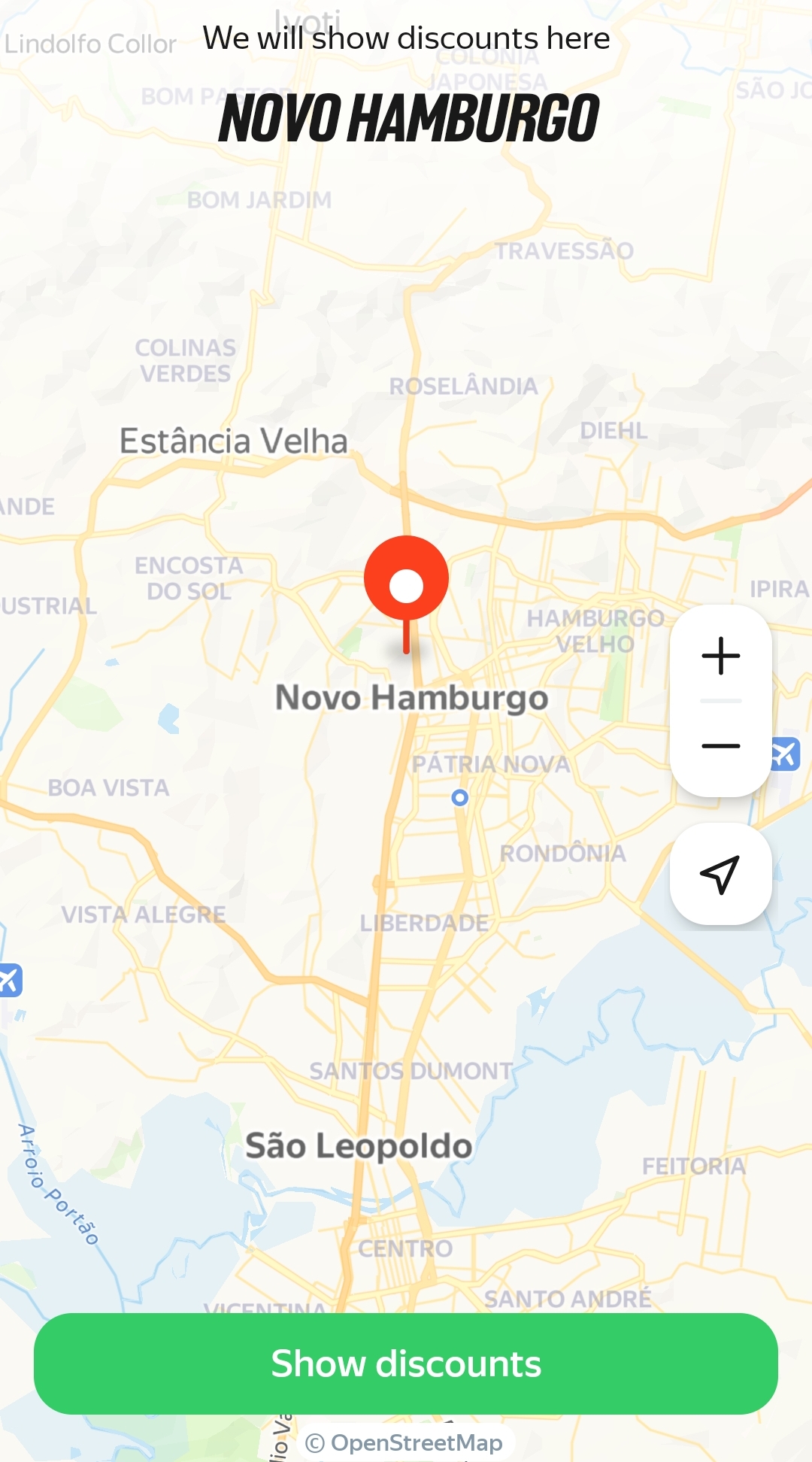
- … o Lessy? Tato mobilní aplikace shromažďuje a nabízí informace o slevách a nabídkách okolních supermarketů s potravinami pro Brazílii, Turecko, Peru, Jihoafrickou republiku, Filipíny, Chile, Argentinu a Kolumbii. Aplikace se jasně hlásí k používání dat OpenStreetMap pro svou podkladovou mapu.
- … že Matt Daniels vytvořil 3D vizualizaci světové populace postavenou na OSM?
OSM v médiích
- [1] Skupina aktivistů SAI CHE PUOI? ► provedla průzkum ► pro spočítání nelegálně zaparkovaných aut v italském Miláně. Cílem je zvýšit dodržování předpisů ohledně parkování a zlepšit plynulost dopravy. Průzkumu se zúčastnilo na 2 000 dobrovolníků, kteří byli rozděleni na 700 malých skupin, které se následně koordinovaly s pomocí mobilní aplikace postavené na OpenStreetMap.
- Časopis CHIP popisuje ► několik pokročilých technik pro vyhledávání míst v OpenStreetMap jako profík. Článek zdůrazňuje možnosti jako Overpass Turbo a vytváření dotazů na Overpass API s pomocí ChatGPT pro zlepšení komfortu a efektivity při hledání a průzkumu nových míst.
- MSPoweruser porovnává Maps.me a mapy Google a hodnotí jejich silné a slabé stránky v několika kategoriích včetně možností práce offline, uživatelského rozhraní, možností vyhledávání, přesnosti a doplňkových služeb. Pomáhají tak uživatelům rozhodnout se, která aplikace lépe vyhovuje jejich potřebám pro navigaci a zkoumání nových míst.
 ►
►
Ostatní geo záležitosti
- Columbus Verlag se specializuje ► na ruční výrobu glóbusů a nástěnných map v Německu se zaměřením na preciznost, ruční práci a udržitelnost. Jedná se o nejstaršího výrobce glóbů na světě fungujícího bez přestávky a je znám i svou kombinací starých technik a moderních technologií.
- Mapy Google zlepšují dostupnost rozšířením detailní navigace hlasem a možností pro čtečku obrazovky Lens pro celý svět. Přidali také další informace pro dostupnost více než 50 milionů prvků mapy pro vozíčkáře. Dále představili atribut Auracast pro firmy podporující naslouchací zařízení, což zjednodušuje lidem s omezeními sluchu navigaci a přístup k informacím.
- Make Ways je platforma, která pomáhá uživatelům map sdílet jejich turistické trasy se zaměřením na dostupnost a uživatelskou zpětnou vazbu pro zlepšení kvality a zážitku z chůze. Plánují také v budoucnu rozšířit platformu o jiné možnosti cestování.
- Kyle Walker publikoval průvodce pro přístup k datům o budovách z Overture Maps a jejich vizualizaci s použitím jazyka R.
- Rozmazáním svého domu na Google Street View chráníte své soukromí a pro cizí osoby je pak obtížnější identifikovat váš domov. Lze to udělat tak, že vyhledáte svůj domů ve službě Street View, vyberete možnost nahlásit problém, určíte příslušnou oblast, kterou chcete rozmazat a odešlete požadavek společnosti Google ke kontrole.
Plánované události
| kde | co | online | kdy | země |
|---|---|---|---|---|
| Saint-Étienne | Rencontre Saint-Étienne et sud Loire | 28.05.2024 |  | |
| San Jose | South Bay Map Night | ✓ | 29.05.2024 |  |
| Gent | OpenStreetMap-meetup + MapComplete birthday party | 28.05.2024 |  | |
| 논현2동 | TomTom & OSM Korea 매핑 파티 | 29.05.2024 |  | |
| Düsseldorf | Düsseldorfer OpenStreetMap-Treffen (online) | 29.05.2024 |  | |
| [Online] OpenStreetMap Foundation board of Directors – public videomeeting | 30.05.2024 | |||
| Postupim | Missing Maps Mapathon Potsdam | 30.05.2024 | | |
| Saarbrücken | Stammtisch OSM Saarland gemeinsam mit OpenSaar e. V. | 31.05.2024 | | |
| Vincent | Social Mapping Sunday: Hyde Park II | 02.06.2024 |  | |
| 臺北市 | OpenStreetMap x Wikidata Taipei #65 | 03.06.2024 |  | |
| Missing Maps London Mapathon | 04.06.2024 | |||
| Westminster | London pub meet-up | 04.06.2024 |  | |
| Berlín | OSM-Verkehrswende #59 | ✓ | 04.06.2024 | |
| OSM Indoor Meetup | 05.06.2024 | |||
| Stuttgart | Stuttgarter OpenStreetMap-Treffen | 05.06.2024 | | |
| Drážďany | OSM-Stammtisch Dresden | 06.06.2024 | | |
| Rio de Janeiro | 💻 Oficina de mapeamento de árvores e cobertura vegetal no OpenStreetMap – YouthMappers UFRJ | 07.06.2024 |  | |
| Kodaň | OSMmapperCPH | 09.06.2024 |  |
Poznámka: Pokud zde chcete vidět vaši akci
Návrhy na zajímavé odkazy pro příští čísla nám můžete poslat zde a podělit se tak o ně s našimi čtenáři.
Toto číslo přeložil tom.k a redakčně upravili mkyral a Jakuje. Budeme velmi rádi, pokud podpoříte a oceníte naši práci tím, že budete dílo dále šířit, např. sdílením na sociálních sítích (like, retweet, boost…). Předem za to děkujeme.
Každé číslo v CZ verzi je promováno zde: @osmcz |
  Talk-cz | osm_sk |
  rss |
rss |  @osmcz
Můžete nás kontaktovat e-mailem:  weekly@openstreetmap.cz
Originál tohoto souhrnu připravili:
LuxuryCoop, MatthiasMatthias, PierZen, SeverinGeo, SomeoneElse, Strubbl, TheSwavu, barefootstache, derFred, mcliquid, rtnf.
LuxuryCoop, MatthiasMatthias, PierZen, SeverinGeo, SomeoneElse, Strubbl, TheSwavu, barefootstache, derFred, mcliquid, rtnf.
I corrected the name of Terence Eden.