05/12/2017-11/12/2017
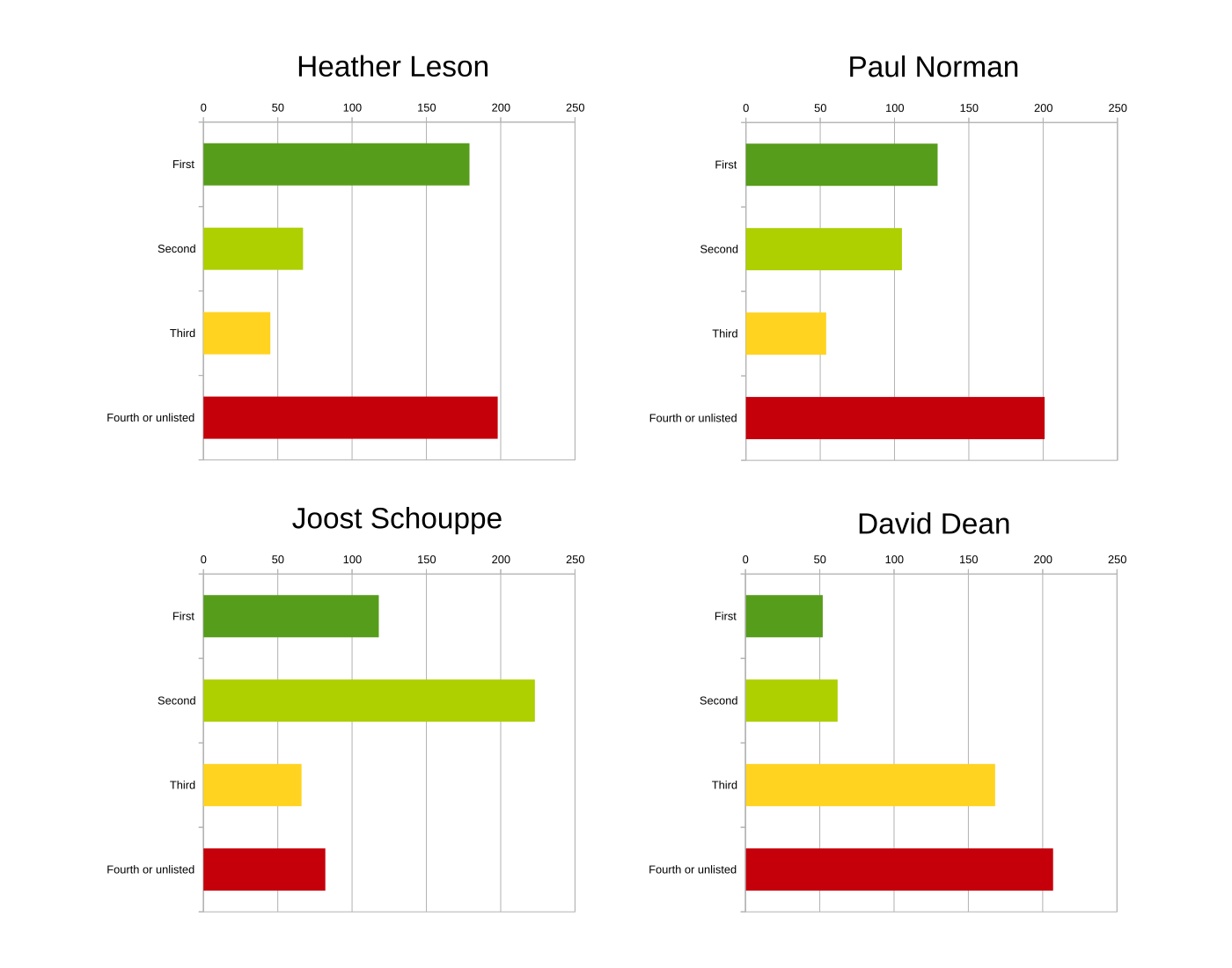
Election results of the four candidates for the OSMF board election 1
Mapping
- Volker Schmidt starts a discussion on tagging sidewalks which present difficulties for people in wheelchairs.
- Marco Boeringa noticed that the value `
college`is missing on the wiki page for,building=*and is of the opinion that the tag building=school is not suitable for this purpose. - After his first proposal was rejected for a number of reasons, Ilya Zverev has a fresh proposal called PTv2 Improvements with regard to Rapid Transit, to change various minor details of the public transport scheme (version 2). See also the discussion on the Tagging mailing list.
- JavaCoyote shares in a blog post how Pokemon Go inspired him to start contributing to OSM.
- Thomas Liebig illustrates the pitfalls of monetary incentives for OSM contributions. His real-world example is of mappers collecting Bitcoin rewards from OSMAnd for adding surface=asphalt to motorways.
Community
- The Regional Court of Dessau-Roßlau passed sentence in the case of the murder of Ulf Möller. Ulf Möller was a mapper, developer and a former member of the OSMF board of directors. He was murdered on 9 January 2012. The Federal Court of Justice in Karlsruhe (Germany) had reversed the first sentence and referred it back to the Regional Court. Spiegel Online reports
 (automatic translation) about it.
 - Geochicas are the new Mappers of the month.
- Users in the German OSM forum discuss the possibility of a public transport tagging reform.
 (automatic
 OpenStreetMap Foundation
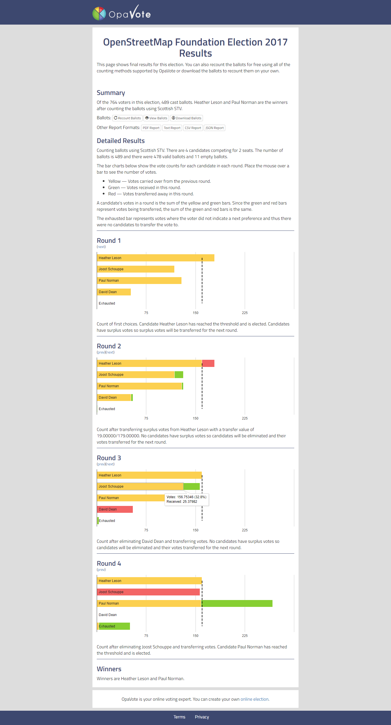
- The results from the elections to Board were announced, we congratulate Heather Leson and Paul Norman for winning these elections!
- Heather Leson thanked the community for her election to the OSMF board. She has however not yet responded to nebulon42’s questions in the comments.
- Tobias Knerr has published an analysis of the results of the OSMF board elections in his user blog. On the OSMF website, there is also a screenshot that helps explain the counting process.
- SunCobalt observes that the number of OSMF members is increasing significantly before elections, and concludes from this that such elections should take place more often. 🙂
- Kate Chapman, the chairperson of the OSM Foundation, has published her annual report in the run-up to the meeting. nebulon42 a critical user on the OSMF mailing list remarked that the report was severely lacking in facts. In response to this Dorothea Kazazi has produced two yearly summaries – a kind of index for the minutes.
- Frederik Ramm, in his role as Treasurer of the OSM Foundation, has published his annual report. In the discussion this sparked on the OSMF mailing list Christoph Hormann asked for a breakdown of travel expenses for scholarships to State of the Map ’17, which Frederik then provided.
- Marc Prioleau introduces the counter-proposal as a guideline for organized editing of the Advisory Board of OSMF to the OSMF mailing list called Organized Editing Best Practice. This is the Advisory Board’s reaction to the draft Directed Editing Policy of the DWG (reported in an earlier OSMWeekly.)
- The OSMF reports in the official OpenStreetMap blog that OSM received a $25,000 donation from the American Red Cross to purchase a fallback server for the OSM API’s main database server. This server is already up and running.
- Frederik Ramm announces that the board of the OpenStreetMap Foundation recognized FOSSGIS e.V. as a Local Chapter of the OpenStreetMap Foundation in Germany.
Humanitarian OSM
- The Humanitarian OpenStreetMap blog shares insights from the OSM & QGIS training session for geology students in Bamako, Mali.
- The OpenStreetMap Niger team received a microgrant by HOT to enable more local mapping efforts to complement the remote mapping.
- An article on dailynews writes about the call made during the State of the Map Tanzania’ meeting in Dar es Salaam where the government and development stakeholders have been urged to rely on the open mapped data results to implement various projects.
Education
- Lukas Toggenburger suggests on the Talk-ch mailing list to offer interested beginning mappers individual mapping training.
Open Data
- The city of Dormagen in Germany now has an open data portal! In the OSM forum it is presumed that this might be a case of openwashing though: In contradiction to the Germany Zero 2.0 data license they should be using, some uses are banned again immediately in additional texts, meaning the data no longer meets the requirements for a free license. This means the data of the city of Dormagen can’t be reused in OSM.
Software
- OsmAnd enables adding Holiday Season’s POIs like Christmas markets.
Did you know …
- … the site raumbezug by Torsten Teubert? He regularly generates OSM maps for Garmin GPS devices.
Other “geo” things
- The app AR-Globe – David Rumsey Maps for the iPhone (iOS 11.0 upwards) provides a playful visualization of historical globes in the current world.
- Using Waze or Google Maps is highly problematic in the Gaza strip. Whether the use of a road is advisable or even allowed depends on whether one is Palestinian, Israeli or a resident of specific zones. Local Palestinians had to start creating their own maps, mostly helped by using Maps.me.
Upcoming Events
| Where | What | When | Country |
|---|---|---|---|
| Denver Online High School Mitchell | PoliMappers‘ Adventures: One mapping quest each day | 2017-12-01-Invalid date |  |
| Taipei | OpenStreetMap Taipei Meetup | 2017-12-18 |  |
| Bonn | Bonner Stammtisch | 2017-12-19 |  |
| Lüneburg | Mappertreffen | 2017-12-19 | |
| Nottingham | Pub Meetup | 2017-12-19 |  |
| Riga | OSM Meetup at Robert’s Books | 2017-12-19 | Latvia |
| Urspring | Stammtisch Ulmer Alb | 2017-12-28 | |
| Dusseldorf | Stammtisch | 2017-12-29 | |
| Essen | Mappertreffen | 2017-12-30 | |
| Rome | FOSS4G-IT 2018 | 2018-02-19-2018-02-22 |  |
| Bonn | FOSSGIS 2018 | 2018-03-21-2018-03-24 | |
| Poznań | State of the Map Poland 2018 | 2018-04-13-2018-04-14 |  |
| Milan | State of the Map 2018 (international conference) | 2018-07-28-2018-07-30 | |
Note: If you like to see your event here, please put it on the calendar. Only data which is there will appear in weeklyOSM. Please check your event in our public calendar preview and correct it, where appropriate.
This weeklyOSM was produced by Nakaner, Polyglot, SK53, Tordanik, YoViajo, derFred, jinalfoflia.