01/31/2017-02/06/2017

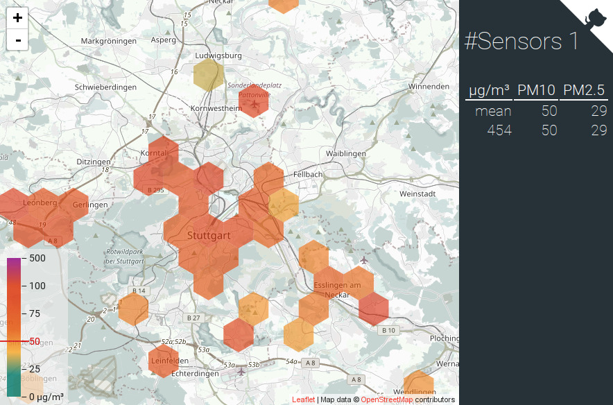
シュトゥットガルト市(ドイツ)のダスト地図 1 | © OpenStreetMap Mitwirkende CC-BY-SA 2.0
マッピング
- Transifex を使って learnOSM の日本語訳を充実させることができます。Transifex はコンテンツの多言語化を助けるためのツールです。
- Jinal Foflia 氏が「OpenStreetMap を始めよう」という記事を書いています。記事ではオープンデータや OSM をマッピングする重要性に触れています。
- Voonosm 氏がドイツ語フォーラムで、定期的に消えたり現れたりする沼をどのようにマッピングするか尋ねています。
- Volker Schmidt 氏がタグ付けメーリングリストで牛の肥育場をどのようにタグ付けするのがベストかという質問をしています。
- Pavel Zbytovský 氏は屋内マッピング用のシンプルインドアタグを、彼が CoreIndoor と呼んでいる内容に拡張したいと考えています。しかし残念なことに彼が拡張しようと思っている部分の多くは間違った前提や誤解によるものになっているため、もっと内容を精査する必要があります。
- トラックの除雪をするための施設
amenity = snow_removal_stationについて、Joachim 氏がタグ付けメーリングリストで意見を求めています。 - イギリスでは小路のオープンデータがあるのですが、データが古く現状とは大きく異なっていることがあります。公的データと現地の状態の差異をどのように扱うべきであるのか英国メーリングリストで議論されています。
- スイスのメーリングリストで Hans Herzig 氏が峡谷のタグ付けについて質問しています。
コミュニティ
- Wa Mbedmi 氏がセネガルの OpenStreetMap コミュニティと、OSM が市民の生活に与える影響について記事を書いています。
- Hernán De Angelis 氏がガーミンのデバイスを通じて知ることができた OpenStreetMap の素晴らしいところをブログで紹介しています。
- ニカラグア共和国の OSM コミュニティはOSM に自転車に関する情報を増やすために、首都マナグアで開催されるワークショップへの参加者を募集しています。
- RichRico 氏は米国国勢調査TIGERデータレイヤーと tofix プラグインを使ってアメリカの道路データの位置や名前などを改善していく方法を書いています。
- Mapbox社のSajjad Anwar氏が、OSMcha と OSM-compareを使った怪しい編集チェック方法について解説記事を書きました。地図データのクオリティを維持するためにはコミュニティの協力が必要であると述べています。
- Joost Schouppe 氏はベルギー政府のように OSM でデータ管理をしている行政府が他にないか尋ねています。
- 林氏が日本にあるバス停の網羅率を可視化するデータを公開しました。日本全国でどのくらいマッパーが活躍しているのかを示すための指標として作成したものだそうです。
インポート
- ウエスト・ミッドランド州(英国)のマッパー達は、属性が増え座標値の精度が高くなった NAPTAN(英国内で公共交通機関に乗り込むためのバス停や空港などの施設情報) データをインポートしようとしていますが、インポートメーリングリストではまだ議論が始まっていません。
イベント
- ペルー共和国のリマで開催予定の SotM ラテンアメリカ 2017 ではロゴコンテストが開催されています。
- 10月にコロラド州ボルダーで開催される予定の State of the Map アメリカ 2017 の正確な開催日はまだ発表されていません。ちなみに、 会津若松で開催される国際カンファレンスの State of the Map 2017 の開催日は2017年8月18日から20日とちゃんと決まっています。
- Stefan Keller 氏が3月10日にスイスのラッパーズヴィールで開催される第8回マイクロマッピングマーティーを紹介しています。
OSM人道支援
- HOT はローカル OSM コミュニティの発展を支援するために「マイクロ支援プログラム」をスタートさせました。GPS デバイスやインターネットアクセス、トレーニングコストの提供を通じてコミュニティのスキル、能力、経験などを向上させるという目標を掲げています。
- HOT は OpenAerialMap がベータ版ではなく正式版になったと発表しました。
- オンラインマッピングによって割礼を逃れることができた女の子がどれくらいいるのか、ガーディアン紙が報告しています。
地図
- 車椅子でアクセス可能な場所の地図を提供する Wheelmap、OSM ベースで作られているこの地図では施設などを表示するアイコンが27個追加されました。
- アメリカの技術系ニュースサイト GeekWire が、ワシントン大学のアクセスマップ研究プロジェクトについて報告しています。ワシントン大学ではさまざまなデータを組み合わせて歩行者や車椅子の利用者に経路検索を提供しているそうです。このプロジェクトはかつてインポート手順やタグ付けの方法を巡って OSM コミュニティの一部からリジェクトされた経過もあります。
オープンデータ
- [1] Stuttgarts Citizen Science では PM2.5 や PM10 といった浮遊粒子状物質を可視化する地図を作成しました。計測された値はいくつかの地域でも見ることができますが、日本の地域には対応していないようです。
ソフトウェア
- Osmand は Android アプリで住所を素早く効率的に検索する方法を GIF 動画で紹介しています。
プログラミング
- Jochen Topf 氏が新しい osmium ツールの速くなった抽出コマンドと、他の既存のツールによる抽出の実行結果をブログ記事に載せています。
- Chris Loer氏(Mapbox社)が、地図ラベルの改行アルゴリズムの改良について解説記事を書きました。改行の扱いは、特にアラビア語など右から左に書く言語の処理時に問題となります。
- 変更セットの最大サイズが50,000から10,000に制限されるようになりました。エディタ開発者の方はご注意ください。
- Nominatimの開発において、地名検索アルゴリズムにエラーがあるにも関わらず修正要求が承認されないとMariusz Rogowski氏が批判しました。Nominatimメイン開発者であるSarah氏およびFrederik氏が丁寧に回答し、プログラムにミスが入り込まないように十分注意していることなどを説明しました。
リリース
| Software | Version | Release date | Comment |
|---|---|---|---|
| Magic Earth * | 7.1.17.5 | 2017-01-31 | Speed warning preferences, night colours, public transport now available in more cities. |
| Vespucci | 0.9.8 | 2017-01-31 | Please read release info. |
| JOSM | 11526 | 2017-02-02 | Hotfix of version 11514. |
| Mapillary iOS * | 4.6.4 | 2017-02-02 | Fixed Crash. |
| Maps.me iOS * | 7.1.4 | 2017-02-02 | Bugs fixed. |
| iD | 2.1.0 | 2017-02-04 | Many changes, please read release info. |
Provided by the OSM Software Watchlist.
(*) unfree software. See: freesoftware.
ご存知でしたか?
- Bhavya Chanra氏が開発した“OSMトレンド都市”では、匿名サーバログを解析し、OSMで表示された頻度の都市別ランキングをTwitterで発表しています。
その他の “ジオ” な事柄
- フィリピン災害対応プロジェクト”NOAH”が資金不足のために2月末で活動を終了することになりました。本プロジェクトではOSMが活用されていました。
- 水路の形から都市名を当ててください。Alex Szabo-Haslam氏がOSMデータを使ったクイズを作成し、ガーディアン紙に掲載されました。
まもなく開催
‘
Note: ここであなたのイベントを見たい場合は、カレンダーにそれを 入れてください。そこにあるデータのみが、週刊 OSM に表示されます。 カレンダー 内で都市や国に言及するのを忘れないでください。
This weeklyOSM was produced by Hakuch, Nakaner, Peda, Rogehm, SeleneYang, derFred, k_zoar, muramototomoya.
