23.03.2021-29.03.2021

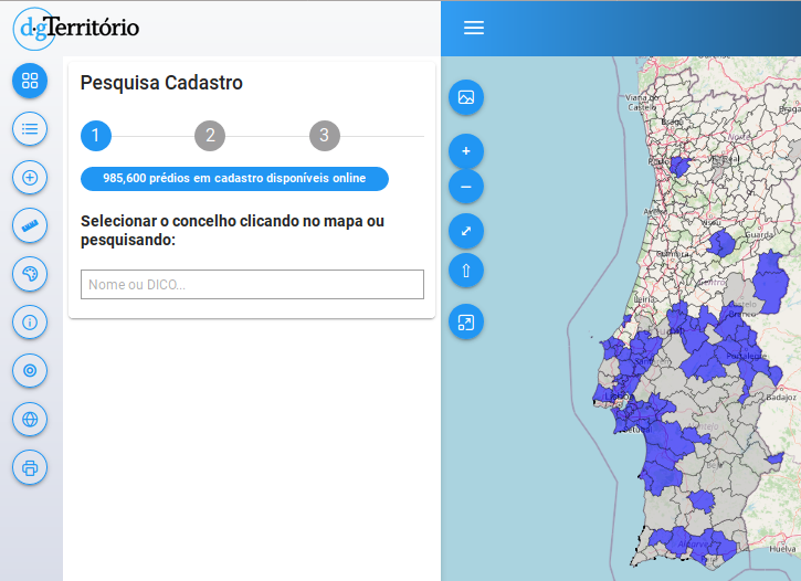
Португальская кадастровая карта [1] | © Direção-Geral do Território | map data © OpenStreetMap contributors
Картографические акции
- Сообщество Code for Charlottesville начало вносить данные о пешеходной инфраструктуре, чтобы помочь сделать город Шарлотсвилл более доступным для людей, испытывающих трудности при передвижении.
- 15 организаций из 8 стран примут с 8 по 10 апреля участие в различных картографических акциях в рамках проекта GeoNight.
- Disastermappers, CartONG и OSMGhana участвуют в Международной неделе против расизма и устраивают 6 апреля совместный онлайн-маппинг.
- Влада Бойцик из Mapbox рассказывает о маппинге французских железнодорожных переездов, который проходил в прошлом месяце.
Картографирование
- Пользователь Nielkrokodil рассказывает
>
о маппинге австрийских пунктов тестирования на коронавирус.
- Предложение по тегу
place_of_worship=holy_wellпринято 10 голосами за и 1 против. - Сайт Rest of World пишет о таинственном пользователе, который приводит данные OSM в соответствие с официальной китайской точкой зрения и об уязвимости OSM и Wikipedia к таким действиям.
Сообщество
- Amazon меняет правила партнёрской программы, и теперь возможность спонсирования FOSSGIS (германского отделения OSMF) переходом по партнёрской ссылке закрывается
>
. За десять лет работы по этой программе было получено около 23 тысяч евро.
- Участник японского отделения OSMF Таро Мацузава (smellman) рассказывает
>
об установке и настройке тайлового сервера.
- Недавняя волна спам-сообщений вызвала оживлённое обсуждение
>
в немецкой ветке форума.
Фонд OpenStreetMap
- Член Совета OSMF Тобиас Кнерр предложил внести в Устав разрешение неполным членам OSMF (associate member) участвовать в выборах в Совет. В настоящее время для участия в выборах нужно провести минимум 180 дней в статусе обычного члена (normal member).
- Клиффорд Сноу из подкомитета модерации LCCWG приглашает принять участие в обсуждении порядка назначения модераторов и пересмотра текущих правил этикета (#543). К настоящему времени подкомитет подготовил общий план работы и план по внедрению. Если хотите поучаствовать – пишите сюда (по 10 апреля).
Карты
Открытые данные
- [1] Правительство Португалии запустило сайт
с данными национального кадастра. В качестве базовой карты используется OSM.
- Японское правительство выложило в открытый доступ 3D-модели зданий 23 кварталов Токио. Посмотреть на них можно здесь
, данные доступны
под лицензией ODbL. Всего планируется выложить 3D-модели 56 японских городов.
Программы
- Сайт pocketnavigation.de написал обзор
>
на навигационное приложение Topo GPS, совмещающее официальные топографические карты и OSM.
- Пользователь rainerU описывает
>
способ фильтрации объектов по их истории с использованием Osmium и osm-tag-csv-history.
Программирование
- Обновив на своём тайловом сервере PostgreSQL до версии 13.2 (POSTGIS 3.1.1), Стефан Кнаусс обнаружил утечку памяти объёмом примерно 2 Гб в час.
А вы знаете …
- … о сайте с интересной исторической информацией и тематическими картами Historic Place?
OSM в прессе
- Haaretz пишет об израильских военных, которые выложили карту с расположением и названиями секретных военных частей. Судя по скриншоту в статье, в качестве базовой карты использовался OSM.
Другие “гео” события
- Грейс Лапойнт представила девять лучших карт из фантастических книг.
- Пока Ever Given сидел на мели в Суэцком канале, он был обозначен в OSM.
- Yama_Chizu опубликовал очень подробную карту
японских дорожных строений. Например, она содержит названия и годы постройки более чем 720 тысяч мостов.
- nagix обновил свою страничку Mini Tokyo 3D. Там появилась симуляция движения солнца и было улучшено отображение самолётов.
Предстоящие события
Примечание: Если вы хотите видеть своё мероприятие здесь, добавьте его в календарь. Данные оттуда автоматически появятся в еженедельнике. Не забудьте указать город и страну.
Над этим выпуском работали: 4004, Climate_Ben, Nordpfeil, TheSwavu, derFred, muramototomoya, richter_fn.

The WeeklyOSM wrote:
> The Israeli newspaper Haaretz featured a story about an Israeli military unit which posted a map on the National Emergency Portal with secret bases of the Israel Air Force and Military Intelligence including names and exact locations. According to the screenshot in the article the base map showing the secret bases is the OSM basemap.
Please note that despite the newspaper’s claim that ” The Home Front Command of the Israel Defense Forces removed the classified information from the map after Haaretz asked about it.”, the Home Front Command did not modify the OSM map or data. Instead, the Covid-19 test centers are now shown using an ESRI base map.
Ref:
1. Original article with blurred base name – https://www.haaretz.com/israel-news/israel-army-secret-bases-online-map-1.9643700
2. Current OSM map of the same area – https://www.openstreetmap.org/#map=11/31.7618/34.9825
3. Home Front Command Covid-19 test centers – https://www.oref.org.il/12605-17147-he/Pakar.aspx
“Die israelische Zeitung Haaretz berichtet (en) > de über eine israelische Militäreinheit, die auf dem Nationalen Notfallportal eine Karte mit geheimen Stützpunkten der Luftwaffe und des militärischen Geheimdienstes inklusive Namen und genauen Standorten veröffentlicht hat. Laut dem Screenshot im Artikel ist die Karte, die die geheimen Stützpunkte zeigt, die OSM-Basiskarte.”
Laut dem Screenshot ist die Karte nicht die aktuelle OSM-Basiskarte (ist nicht osm carto), beruht aber wohl auf OSM Daten, evtl. ist es eine ältere Version des Mapnik-Stils. Laut Artikel kamen die “geheimen Daten” komplett von OSM und wurden nicht von der Militäreinheit die die Karte veröffentlicht hat, hinzugefügt: “In a statement, it added the map is from “a civilian website that provides global public services for making maps accessible around the world and in Israel. Marking the IDF camps and bases was not done by the military, but copied from the existing map on the website.”” Wahrscheinlich sind weitere Informationen zu diesen “geheimen” Stützpunkten der Wikipedia zu entnehmen…