2021/03/23-2021/03/29

國家地籍資訊系統 – 葡萄牙 [1] | © Direção-Geral do Território | 地圖資料 © 開放街圖貢獻者
每週練習
- Code for Charlottesville 正在 OSM 上面新增人行道、人行穿越道與路緣資料。這是為了讓維吉尼亞州夏洛茨維爾一帶能夠為行動不便的行人導航,特別是輪椅導航。該專案活動在其教學部分進行了描述,但仍在積極審查中,因此歡迎提出意見和回饋。
- 作為第五屆 GeoNight(「地理之夜」)的一部分,4月8日星期四、4月9日星期五以及4月10日星期六舉辦了許多場線上缺失地圖圖客松。這些地圖競賽是與8個國家的 15 個組織共同組織籌辦:法國,德國,馬利,塞內加爾,孟加拉,尼泊爾,蒙古和塔吉克。
- 德語的 Telegram 群組制定了每週一次的繪圖重點清單,主題相當廣泛。
- Disastermappers、CartONG 與 OSMGhana 提前至格林威治標準時間4月6日星期二下午4:30舉辦線上圖客松活動,海德堡市跨文化中心贊助此次活動,您可以在這裡報名參加此次活動。
- Mapbox RAVE 團隊的 Vlada Boitsik 寫了一篇日記,介紹團隊在三月份進行組織性編輯活動,編輯法國鐵路平交道。
畫地圖
- Nielkrokodil 在他的使用者日記中公佈
 >詳細說明他如何記錄和維護奧地利 COVID-19 檢測站的繪圖行動。
 - 每年一次天主教徒用來慶祝聖井的守護神,
place_of_worship=holy_well設施的提案,已經獲得了必要的票數得到批准了。 - 《Rest of World》刊登了一篇文章,講述了一位神秘的 OSM 編輯為了配合中國的觀點而更改 OSM 資料,維基百科和 OSM 等開放資料專案容易受到這種類型的操縱,並描述了過去「糾正」資料的努力。
 >
>
社群
- 隨著伙伴政策的改變,亞馬遜不再與德國的 OSM> 分享部分收入。到目前為止,這個可以通過特殊連結使用的方案已經為 OSM 賺取了 23,000 歐元,但最近收入一直在下降。
- Jean-Christophe Becquet (APITUX>) 在 "Dessinetaville: introduction to collaborative mapping"(影片)中展示了OpenStreetMap,該會議由 Médiathèque de Chorges(法國上阿爾卑斯省)組織。
- 德國維基媒體協會報導>自疫情大流行開始以來,維基百科的編輯量顯著增加。特別是在第一階段,編輯數量增加了 30% 至 80%,而在2020年夏季,這個趨勢開始緩和。
- OSMFJ 成員松澤太郎(使用者 smellman)貢獻了> 一篇題目為 "OpenStreetMap Foundation Japan Example of building a tile server for the community" 的文章,其中詳細介紹了地圖圖磚系統和建構圖磚伺服器。
- 最近在 OSM 中垃圾訊息大量增加,引起了德國論壇上相當長的討論>,在討論過程中,一些不切實際的預期,像是垃圾訊息發送者被阻止後的回應時間,必須得到糾正。
 >
> >
>開放街圖基金會
- OSMF 理事會成員 Tobias Knerr 宣布了一項提案,建議修改 OSMF 的協會章程,允許長期準會員競選理事會成員。目前,你必須成為 OSMF 成員至少180天,準成員資格則不計入其中。
- Clifford Snow 代表 LCCWG 版主小組委員會邀請大家參與為 OSMF-talk 和 talk 郵件論壇建立版主團隊的過程,並審查現有的禮節準則(我們稍早報導過)。到目前為止,小組委員會已經制定了工作範圍,並最終確定了實施計劃。您可以通過這個表格表達對參與這個過程的興趣。表達興趣的截止日期為4月10日星期六。
地圖
開放資料
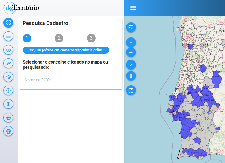
- 葡萄牙政府領土總局提供了國家地籍資訊系統的線上檢視器,可以查詢土地登記資料和土地所有權結構。底圖採用 OpenStreetMap。
- 由日本政府,特別是國土交通省 (MLIT) 實施的「PLATEAU 專案」發布了東京 23 區的 3D 城市資料。這些 3D 模型也可以線上檢視。該資料可在 ODbL 授權下查閱。日本 56 個城市的 3D 資料將作為開放資料提供。
 的線上檢視器,可以查詢土地登記資料和土地所有權結構。底圖採用 OpenStreetMap。
 。該資料可在 ODbL 授權下
軟體
- pocketnavigation.de 回顧了> Topo GPS,一款成熟的戶外導航應用程式,它結合了官方地形圖和 OpenStreetMap,以及良好的定位和規劃功能,操作簡單,成本低廉。
- 使用者 rainerU 描述了>如何使用 Osmium 和 Rory McCann 的 osm-tag-csv-history,依據標籤歷史和涉及的使用者過濾 OSM 物件。
程式開發
- Stephan Knauss 在更新他的彩現堆疊到 PostgreSQL 13.2 / POSTGIS 3.1.1之後,注意到每小時大約有 2GB 的記憶體洩漏。在不知道原因的情況下,許多問題仍有待解答。
你知道嗎?
- ……歷史悠久的地方,一個開放的世界地圖?有12種語言與特殊地圖!
媒體中的 OSM
- 以色列《國土報》刊登了一篇報導,稱以色列一個軍事單位在國家救難平台網站上張貼了一張地圖,上面有以色列空軍和軍事情報局的秘密基地,包括名稱和確切位置。根據文章中的截圖,顯示秘密基地的底圖是 OSM 底圖。
其他地理事情
- Grace Lapointe 介紹了九張在書中發現的最好的幻想地圖。
- 雖然「長賜輪」在蘇伊士運河擱淺,但在 OSM 中也是人人可見的 😉
- Ciaran Staunton 在推特上發布了一個關於 OSM 貢獻者和消費者之間關係的棒棒模因。
- Yama_Chizu 在全國 Q 地圖上發布了全國道路結構圖。例如,你可以查看日本約七十二萬座橋樑的名稱和竣工年份。
- nagix 發布 Mini Tokyo 3D 2.8.0 版本。目前天空的顏色和太陽的移動都被模擬出來了。此外,飛機追蹤也得到了改善。
未來活動
| 地點 | 活動名稱 | Online | 日期 | 所在國 |
|---|---|---|---|---|
| OpenStreetMap World Discord Spring Mapathon | 2021-04-03 – 2021-04-04 | |||
| 京都市 | 京都!街歩き!マッピングパーティ:第23回 Re:常寂光寺 | 2021-04-04 | jp | |
| Heidelberg | International Mapathon: Weeks Against Racism | ✓ | 2021-04-06 |  |
| London | Missing Maps London Mapathon | ✓ | 2021-04-06 | gb |
| Landau an der Isar | Virtuelles Niederbayern-Treffen | ✓ | 2021-04-06 | |
| Stuttgart | Stuttgarter Stammtisch (Online) | 2021-04-06 | | |
| Numérique Éducatif Libre Webinaire : Quels usages pédagogiques avec OpenStreetMap ? | 2021-04-07 | |||
| OSM Hour: Talking about the motivation of our industrial sponsors, shared to-do lists (online) | 2021-04-07 | |||
| Missing Maps Artsen Zonder Grenzen Mapathon | 2021-04-08 | |||
| Missing Maps Studentendesk Rode Kruis Maastricht | 2021-04-08 | |||
| Dresden | Dresdner OSM-Stammtisch | ✓ | 2021-04-08 | |
| Berlin | 154. Berlin-Brandenburg OpenStreetMap Stammtisch (Online) | 2021-04-09 | | |
| Charlottesville | Cville Sidewalks Mapathon | 2021-04-11 |  | |
| 臺北市 | OpenStreetMap x Wikidata 月聚會 #27 | 2021-04-12 |  | |
| Hamburg | Hamburger Mappertreffen | 2021-04-13 | | |
| Using maps to help prevent and respond to Gender Based Violence | 2021-04-14 | |||
| Chippewa Township | OpenStreetMap Michigan Meetup | ✓ | 2021-04-15 | |
| Zürich | 3. Mapathon Rapperswil mit Missing Maps Zürich (virtuell) | ✓ | 2021-04-14 |  |
| Osborne County | OpenStreetMap U.S. Virtual Mappy Hour | ✓ | 2021-04-15 | |
| Liverpool | University of Liverpool Mapathon 2021! | 2021-04-15 | gb | |
| San Jose | Virtual Civic Hack & Map Night | ✓ | 2021-04-16 | |
| PoliMappers: Humanitarian Mapping with Map For Future | 2021-04-16 | |||
| 138. Treffen des OSM-Stammtisches Bonn | 2021-04-20 | |||
| City of Nottingham | OSM East Midlands/Nottingham meetup (online) | ✓ | 2021-04-20 | gb |
| Berlin | OSM-Verkehrswende #22 (Online) | 2021-04-20 | | |
| Lüneburg | Lüneburger Mappertreffen (online) | 2021-04-20 | | |
| Albuquerque | MapABQ April virtual meetup | 2021-04-22 | | |
| Weggis | Swiss OpenStreetMap Association Annual General Meeting | 2021-04-23 | |
註: 你也可以在這裡展示你發起的活動!只須在行事曆上塡妥活動資訊即可。 只有記載於行事曆上的活動資訊才會在《週刊OSM》列出。你也可以在行事曆預覽檢查你提交的活動, 並作出適當更正。
這期 weeklyOSM 由 Climate_Ben, Nordpfeil, Supaplex, TheSwavu, derFred, muramototomoya, s8321414 編譯 ##team##
The WeeklyOSM wrote:
> The Israeli newspaper Haaretz featured a story about an Israeli military unit which posted a map on the National Emergency Portal with secret bases of the Israel Air Force and Military Intelligence including names and exact locations. According to the screenshot in the article the base map showing the secret bases is the OSM basemap.
Please note that despite the newspaper’s claim that ” The Home Front Command of the Israel Defense Forces removed the classified information from the map after Haaretz asked about it.”, the Home Front Command did not modify the OSM map or data. Instead, the Covid-19 test centers are now shown using an ESRI base map.
Ref:
1. Original article with blurred base name – https://www.haaretz.com/israel-news/israel-army-secret-bases-online-map-1.9643700
2. Current OSM map of the same area – https://www.openstreetmap.org/#map=11/31.7618/34.9825
3. Home Front Command Covid-19 test centers – https://www.oref.org.il/12605-17147-he/Pakar.aspx
“Die israelische Zeitung Haaretz berichtet (en) > de über eine israelische Militäreinheit, die auf dem Nationalen Notfallportal eine Karte mit geheimen Stützpunkten der Luftwaffe und des militärischen Geheimdienstes inklusive Namen und genauen Standorten veröffentlicht hat. Laut dem Screenshot im Artikel ist die Karte, die die geheimen Stützpunkte zeigt, die OSM-Basiskarte.”
Laut dem Screenshot ist die Karte nicht die aktuelle OSM-Basiskarte (ist nicht osm carto), beruht aber wohl auf OSM Daten, evtl. ist es eine ältere Version des Mapnik-Stils. Laut Artikel kamen die “geheimen Daten” komplett von OSM und wurden nicht von der Militäreinheit die die Karte veröffentlicht hat, hinzugefügt: “In a statement, it added the map is from “a civilian website that provides global public services for making maps accessible around the world and in Israel. Marking the IDF camps and bases was not done by the military, but copied from the existing map on the website.”” Wahrscheinlich sind weitere Informationen zu diesen “geheimen” Stützpunkten der Wikipedia zu entnehmen…