03/04/2025-09/04/2025
[1] Customised route planning with Bikerouter | © bikerouter © Margrit Höhme | Map data © OpenStreetMap contributors
Mapping
- Please cast your vote in the proposal to map grab rails in (wheelchair accessible) toilets.
- Comments are being requested for these proposals:
- A tagging scheme proposal for windmills and watermills that aims to clarify the distinction between
building=windmillandman_made=windmill. It also proposes the introduction of a new key,windmill=*, to further refine the classification of these structures. armrest:*=*for tagging whether of not a toilet is equipped with arm rests.
- A tagging scheme proposal for windmills and watermills that aims to clarify the distinction between
Community
- Pedro Tharg wrote
 ►, in his diary, about using MapBiomas data in OpenStreetMap and suggested tagging for different land cover and land use classes. MapBiomas is a collective project that officially began in Brazil in July 2015 and is organised collaboratively by NGOs, universities, laboratories, and technology start-ups.
 - Looking for a holiday destination for hiking or cycling? How about a region where many paths in OpenStreetMap don’t yet have any surface information? Nakaner’s presentation at FOSSGIS 2025 and the maps he produced will show you where your help is needed. The slide deck from the presentation and the map are available, and you can watch his video.
 ►
►
 available, and you can
 OpenStreetMap Foundation
- Michael Spreng, from the OpenStreetMap Foundation’s Membership Working Group, announced that OSMF members will now need to renew their memberships manually, as the foundation has temporarily halted automatic renewals via PayPal. The decision follows ongoing issues with the automated system, where payments often fail to register correctly.
Events
- Dani Waltersdorfer, a board member of the OpenStreetMap Foundation, has shared her insights following her participation in the State of the Map Latin America 2024 conference, held in Belém, Brazil.
- FOSSGIS announced ► the successful completion of the 2025 FOSSGIS Conference, held in Münster from 26 to 29 March. Co-organised with the OpenStreetMap community and the University of Münster’s Institute for Geoinformatics, the event took place at Münster Castle, with a large tent on the castle square accommodating attendees and hosting exhibits and posters. Over 1000 participants joined, including 750 on-site and more than 350 online.
- The recordings of the FOSSGIS 2025 conference are available . These include vehicle localisation in DB Regio [1] , coordinate reference systems for D-A-CH [2] and 2.5D indoor maps based on OpenStreetMap data [3] .
- Séverin Ménard will conduct a virtual workshop, in English, on mapping building damage using post-disaster imagery in OpenStreetMap on Thursday 17 April at 7:00 PM UTC via BigBlueButton. The session will cover mapping techniques using JOSM and mark the kick-off of a mapathon focused on the French overseas department of Mayotte, which was damaged by Cyclone Chido at the end of 2024.
- Volker Krause shared his insights and personal notes on OSM indoor navigation, the Transitous public transport routing service, and OpenTransport, following his participation in the FOSSGIS Conference 2025.
- The State of the Map Organising Committee has launched a travel grant programme, aimed at enhancing accessibility for participants attending the State of the Map 2025 Conference, set to take place in Manila from 3 to 5 October. Applications for the grant are now open and will be accepted until Friday 16 May at 12:00 UTC.
Education
- Mapeducação, a programme that aims to map public and private schools and educational institutions has started ► in the Municipality of Jacobina, Bahia, Brazil. The programme aims to facilitate access to the schools’ data, helping to facilitate the enrolment process, for example.
Maps
- OpenLocalMap is a map of Catalonia originally created [ca] from a project run [ca]► by the non-profit association la Konfraria de la Vila del Pingüí, from la Palma de Cervelló. Now maintained by OSM-Catalan, the map incorporates data from la Palma de Cervelló and Vilanova i la Geltrú from OpenStreetMap. The code is available on GitHub.
OSM in action
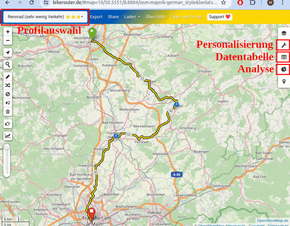
- [1] Herr Voeglein tooted that the latest issue of Fahrrad Zukunft featured ► an in-depth article on BRouter, a customisable, elevation-aware bike routing app that uses OSM data. The article also outlined how to connect the BRouter Android app to Osmand, OruxMaps, or LocusMap.
Software
- Jake Low’s pull request has resulted in OSMCha now getting changes from an OSM adiff service, rather than using the Overpass API. This code change should result in OSMCha being able to handle displaying larger changesets more quickly.
- Ralph Straumann reported that Fabian Rechsteiner has developed a performance benchmark comparing six open-source vector tile servers that are used to deliver tiles from a PostgreSQL/PostGIS database.
Programming
- Nick Walker has added Overpass QL syntax highlighting support for
.overpassqlfiles on GitHub. It is based on the Overpass QL syntax VS Code extension and was made possible by standardising the file extension (we reported earlier). - Kumakyoo continued his series on his new OMA file format with a description of how relations are handled.
Releases
- MapLibre has published its March Newsletter with notices about new releases for the MapLibre GL JS and the Martin Tile Server.
- Version 2.1.0 of osm2pgsql has been released, bringing several enhancements aimed at better integration with connection poolers and other database middleware.
Did you know that …
- … the OSM welcome tool can be used to monitor and message new contributors in your region? It’s a great help to send a welcome message to new OSM members and inform them about local chat groups and such. Messages like this can increase the likelihood of those users sticking around and continuing to contribute to OSM.
Other “geo” things
- Between science and art, the ‘Forest Cartographies’ exhibition is showcasing ► HD LiDAR data, from the Marne forests, from 8 April to 28 June in Reims (France).
- Several car accidents linked to Google Maps have occurred ► during Indonesia’s recent Mudik season, a massive annual homecoming ahead of Eid al-Fitr, involving millions of travellers. A driver in Ponorogo ended up stranded in a rice field after following Google Maps directions onto what turned out to be a non-public road. In a separate incident in Gresik, a BMW sedan drove off the edge of an unfinished ► toll road.
- EOS Landviewer offers users free access to 10 satellite imagery scenes per day, including recent high-resolution data from Sentinel-2 L2A and Landsat 8 RT.
- Christopher Beddow discussed the distinction between discovery and rediscovery, arguing that the act of digitising elements of the physical world constitutes a form of rediscovery. By transforming tangible realities into digital formats, knowledge once confined to a select few becomes accessible to all, unlocking the potential for instant, widespread awareness.
- Texty.org.ua has published ► an analysis on the disappearing snow in Ukraine, noting that the last snowy winter across much of the country occurred in 2020–2021, with the most widespread and heavy snowfall recorded in 2016–2017. Citing data from MODIS satellite imagery, they highlight a cyclical trend; snowier winters tend to follow several years with little to no snow.
- The BnF (French National Library) has been backing up ► French websites since 2006 by automated collection, in a similar way to the Internet Archive. Pierre Bonneau and Dorothée Benhamou-Suesser (from the BnF) noted that this method is very effective for many sites but not for dynamic sites such as OSM. Even when queries are programmed, the collection and output are generally of poor quality or even non-existent. Christian Quest replied that it has been proposed in the past to provide VMs (virtual machines) of the tile generator, with the data frozen at 1 January and using the map style of the time, as demonstrated in this prototype. The rest of the discussion identified the most suitable solution as a VM for each past and future year, using an LXC container.
- Charlie Plett has created an interactive historical map of Mennonite villages powered by OpenHistoricalMap and MapLibre.
 ►
► ►
► ►
►Upcoming Events
| Where | What | Online | When | Country |
|---|---|---|---|---|
| København | OSMmapperCPH | 2025-04-13 |  | |
| Delhi | 15th OSM Delhi Mapping Party | 2025-04-13 |  | |
| Grenoble | Atelier adressage dans OpenStreetMap | 2025-04-14 |  | |
| 中正區 | OpenStreetMap x Wikidata Taipei #75 | 2025-04-14 |  | |
| Missing Maps London: (Online) Mid-Month Mapathon [eng] | 2025-04-15 | |||
| Lyon | Réunion du groupe local de Lyon | 2025-04-15 | | |
| Bonn | 187. OSM-Stammtisch Bonn | 2025-04-15 |  | |
| San Jose | South Bay Map Night | ✓ | 2025-04-16 |  |
| Lubbock | A Synesthete’s Atlas: Cartographic Improvisations | 2025-04-16 | | |
| Lüneburg | Lüneburger Mappertreffen | ✓ | 2025-04-15 | |
| Amsterdam | Maptime Amsterdam: Springtime Mapping Party | 2025-04-16 |  | |
| Marche-en-Famenne | OpenStreetMap Belgium au salon Municipalia | 2025-04-17 – 2025-04-18 |  | |
| MapRVA Map & Yap | 2025-04-18 | |||
| Workshop – mapathon: post-cyclone assessment of building damage | 2025-04-17 | |||
| OSMF Engineering Working Group meeting | 2025-04-18 | |||
| Mumbai City | 2nd Mumbai Mapping Party | 2025-04-20 | | |
| Aketi | Mapathon for Kinshasa City, | 2025-04-21 – 2025-04-25 |  | |
| Hannover | OSM-Stammtisch Hannover | 2025-04-22 | | |
| Kiel | Kieler Mapper*innentreffen | 2025-04-22 | | |
| Derby | East Midlands pub meet-up | 2025-04-22 |  | |
| Missing Maps – DRK & MSF Online Mapathon | 2025-04-23 | |||
| [Online] OpenStreetMap Foundation board of Directors – public videomeeting | 2025-04-24 | |||
| Zaragoza | Mapatón Humanitario Universidad de Zaragoza | 2025-04-24 |  | |
| Atelier – mapathon: évaluation post-cyclonique des dommages aux bâtiments | 2025-04-24 | |||
| SOSM Annual General Assembly | 2025-04-25 | |||
| OSMF Affiliation Focus Group Discussion: Thematic and non-geographical groups | 2025-04-26 |
Note:
If you like to see your event here, please put it into the OSM calendar. Only data which is there, will appear in weeklyOSM.
This weeklyOSM was produced by MatthiasMatthias, Raquel Dezidério Souto, SeverinGeo, Strubbl, TheSwavu, YoViajo, barefootstache, derFred.
We welcome link suggestions for the next issue via this form and look forward to your contributions.