09/05/2024-15/05/2024
Women participating in OpenStreetMap, a survey. Image by Ohene123 [1]
Mapping
- Salim has set up
 a new challenge on MapRoulette called ‘Portugal – Fix Spiky Buildings’, which aims to correct inaccurately mapped buildings identified on OpenStreetMap, some of which may be correct but many of which are likely errors.
 - The proposal to set the tag
shop=tortillais in the voting phase until Sunday 26 May.
 a new challenge on
 Mapping campaigns
- Tushar V recounted his experience of participating in an OpenStreetMap mapping party for the first time.
Community
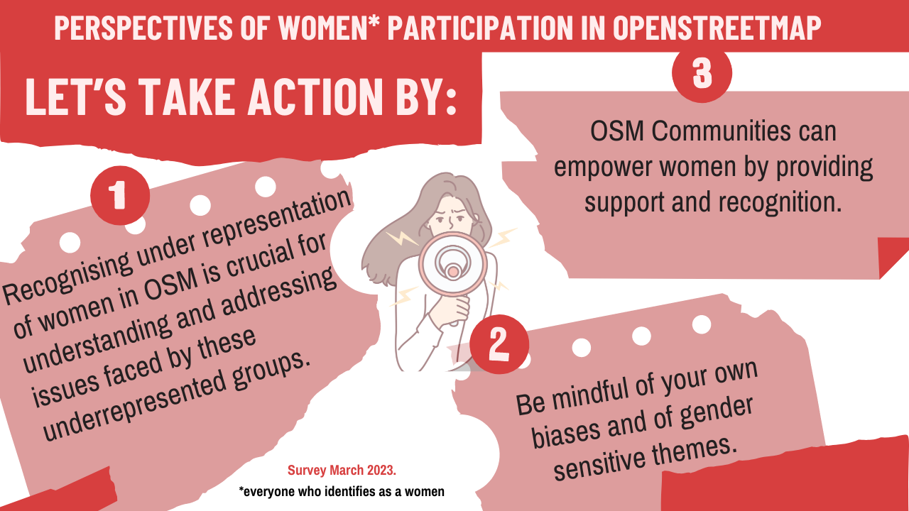
- [1] Benedicta Banful Ohene-Amadi has provided an update on a survey on women’s participation in OpenStreetMap, revealing different perspectives on the issue from women and men, and highlighting the importance of understanding and addressing different viewpoints in mapping activities.
- Nikita Ushakov explained ► the basics of OpenStreetMap editing using MapComplete, EveryDoor, and Vespucci.
 ►
►
Events
- Włodzimierz Bartczak tooted that the State of the Map Europe 2024 event programme is now available and hints that more details will be coming soon. It’s also the final call for proposals for presentations and workshops, inviting those with solutions based on OpenStreetMap data or discussions about the project’s history to participate (open until Friday 31 May).
- FOSSGIS will host the 22nd OpenStreetMap Community Meeting this October in Essen, Germany.
- State of the Map Europe 2024 is fully embracing Mastodon for communication, with a monitored account run by @etua_en and @Cristoffs. They encourage anyone with questions about the conference to tag them with @sotmeu for support.
- The call for venues to host the State of the Map 2025 is now open until Sunday 21 July.
Education
- Alexandre Marques explained ► how to create interactive online maps using uMap, an open source tool that integrates OpenStreetMap layers, allowing users to add markers, lines, and polygons, import geospatial data, manage layers, and share maps through downloadable formats or embedded iframes on websites.
- Séverin Ménard was invited to lead a workshop on river mapping in OpenStreetMap, using documentation published on the UN Maps Learning Hub. The workshop was organised by an oceanographer and president of the IVIDES, Dr Raquel Dezidério Souto, who provided ► more details in her diary. The video is available.
 ►
►OSM research
- The United States Census Bureau has developed a socioeconomic profile of the commuters affected by the collapse of the Francis Scott Key Bridge, in Baltimore, based on OSM data and OSRM.
Maps
- Daniel J. H. explored in detail the evolution and mechanics of OpenStreetMap’s vector tiles, highlighting their advantages over raster maps, detailing the Mapbox vector tile specification, and discussing challenges such as data redundancy across tiles.
- Tino Dietel has created Freifunk Karte, a map that lists free wifi locations provided by the Freifunk movement.
- Kamil Monicz detailed the ongoing preparations for the first development release of their OpenStreetMap NextGen project, including improvements to the elements sidebar, a preliminary implementation of the API 0.7, and general code cleanup.
- The IVIDES has created a dynamic web map, using uMap, to support the actions being taken to combat the effects of the flooding in the state of Rio Grande do Sul that resulted in a significant humanitarian crisis. Official data on the hydrology of the affected region is available in the map documentation ►. Specifically, the polygons of flood areas were generalised from data from the National Institute for Space Research, which is also available from the ‘Flooding in Brazil’ activation on Disaster Charter. This initiative was blogged ► in Dr Raquel Dezidério Souto’s diary.
OSM in action
- Reddit user AtmosphericBeats has created a 1:1 scale map of Baltimore in Minecraft, using OpenStreetMap data to accurately represent real building heights, street networks, pavements, parks, and more. This detailed model allows users to explore Baltimore in a virtual environment that mirrors the real city.
- eMerzh tooted about an enjoyable cycling experience he had with his kids, highlighting a useful OpenStreetMap sign for cycling routes and appreciating its good attribution. Smveerman mentioned that you can order a free paper copy of this map from the Walloon government on their official site. Pieter Vander Vennet pointed out that MapComplete.org allows users to participate in creating their own maps.
- The KF Map provides a detailed digital map of Indonesia’s infrastructure, with a particular focus on Jakarta. It includes data on various property types, facilities, and key infrastructure elements such as toll roads, airports and seaports, facilitating comprehensive urban and regional planning and analysis.
Licenses
- Foxy found that the administrative boundary information in Overture Maps, which includes data from OpenStreetMap, is currently licensed under ODbL. Previously, this data was sourced from Esri and TomTom and was licensed under the CDLA Permissive 2.0 licence.
Software
- Marcus Jaschen announced ► several updates to the bikerouter.de website, an OpenStreetMap-based bicycle routing app derived from brouter-web. These updates include a migration of the web server from Nginx to Caddy, a migration of the server to an ARM64-based architecture, and a migration of the operating system to Ubuntu 24.04.
- Beakerboy has developed a 3D renderer web application allowing users to visualise an individual building object from OpenStreetMap.
 ►
►Programming
- Andrii Holovin has proposed a solution to the impasse in transitioning the Switch2OSM project to a new platform. He suggested preserving the current version on Jekyll as a historical artefact and starting anew by transferring the materials to MkDocs, a step he took over a year ago.
Releases
- Garmin has released a new CycleMap and TopoActive map update, version 2024.10, for compatible wearable and handheld GPS devices. It improves navigation with updated map data while maintaining the same memory footprint. In case you didn’t know, these maps are based on OpenStreetMap data.
- Bryan Housel announced the release of Rapid v2.3 for OpenStreetMap, introducing features such as Esri Wayback imagery for historical views, map rotation, MapRoulette integration for task management, and GeoScribbles for field notes.
OSM in the media
- The Shinano Mainichi Shimbun, a local newspaper in the Hokuriku region of Japan, reported ► the completion of a highway repair project using an OpenStreetMap road route illustration. The highway had previously been damaged in 30 locations by the Noto Peninsula earthquake.
 ►
►Other “geo” things
- Heise Online reported ► on several projects that aim to detect GNSS signal disruption globally: Flightradar24 GPS Jamming Map and GPSJAM.
- Researchers are developing a high-resolution, impact-based flood forecasting, and early warning system that will provide near-real-time flood forecasts with uncertainties to improve disaster preparedness and response.
- Google Maps has launched ► a live tracking feature for TransJakarta buses, much to the delight of many Jakarta citizens. Through its Google Transit Partner initiative, Google is open to collaborations with any public transportation agency that is interested in providing real-time updates to Google Maps.
- Amir Shoam, in TechSpot, explained the history of MapQuest, a web-based navigation service that was popular around 1999 and in 2010 became the first large online mapping service to embrace OSM.
 ►
►Upcoming Events
| Where | What | Online | When | Country |
|---|---|---|---|---|
| Salt Lake City | OSM Utah Monthly Map Night | 2024-05-17 |  | |
| Bayonne | Rencontre Groupe local Pays Basque – Sud Landes | 2024-05-17 |  | |
| Gambir | Monthly Mapping Talks | 2024-05-17 |  | |
| Gandhi Nagar Tehsil | 8th OSM Delhi Mapping Party – Day 1 | 2024-05-18 |  | |
| Durham | Mapping around University of New Hampshire | 2024-05-19 | | |
| Kalkaji Tehsil | 8th OSM Delhi Mapping Party – Day 2 | 2024-05-19 | | |
| England | OSM UK Online Chat | 2024-05-20 |  | |
| Lyon | Réunion du groupe local de Lyon | 2024-05-21 | | |
| Bonn | 175. OSM-Stammtisch Bonn | 2024-05-21 |  | |
| UN Mappers training – Validating OSM data – session #10 | 2024-05-22 | |||
| iD Community Chat | 2024-05-22 | |||
| Zürich | Missing Maps Zürich Mai Mapathon | 2024-05-22 |  | |
| Rio de Janeiro | 💻 Oficina de mapeamento de feições importantes na redução de riscos de desastres (RRD) – YouthMappers UFRJ | 2024-05-24 |  | |
| OSMF Engineering Working Group meeting | 2024-05-24 | |||
| San Jose | South Bay Map Night | ✓ | 2024-05-29 | |
| Gent | OpenStreetMap-meetup + MapComplete birthday party | 2024-05-28 |  | |
| Düsseldorf | Düsseldorfer OpenStreetMap-Treffen (online) | 2024-05-29 | | |
| [Online] OpenStreetMap Foundation board of Directors – public videomeeting | 2024-05-30 | |||
| Potsdam | Missing Maps Mapathon Potsdam | 2024-05-30 | | |
| Saarbrücken | Stammtisch OSM Saarland gemeinsam mit OpenSaar e. V. | 2024-05-31 | | |
| City of Vincent | Social Mapping Sunday: Hyde Park II | 2024-06-02 |  | |
| 臺北市 | OpenStreetMap x Wikidata Taipei #65 | 2024-06-03 |  |
Note:
If you like to see your event here, please put it into the OSM calendar. Only data which is there, will appear in weeklyOSM.
This weeklyOSM was produced by MatthiasMatthias, SeverinGeo, Strubbl, TheSwavu, barefootstache, conradoos, mcliquid, miurahr, rtnf.
We welcome link suggestions for the next issue via this form and look forward to your contributions.