2020/12/01-2020/12/07
大事件
- 在 2020 年年度大會
 > 上選舉 OSMF 理事會成員,爭取今年的三個席位,結果 Tobias Knerr(再次當選連任)、Jean-Marc Liotier 和 Eugene Alvin Villar(使用者 seav)當選。對組織章程進行修改的決議(我們早些時候報導過)和其他三項決議都成功通過。
 >
> 
畫地圖
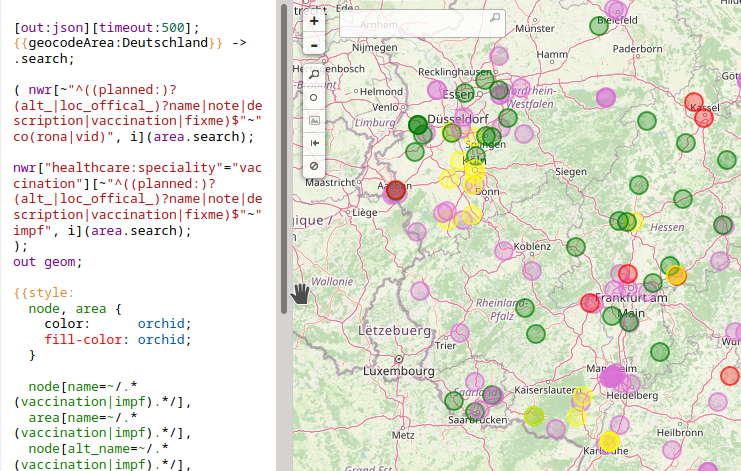
- [1] 德國 OSM 論壇正在討論> 要如何繪製德國 COVID-19 疫苗接種中心的地圖,其位置目前正在當地的媒體發佈。他們還詢問是否有人想要發佈這些中心的地圖。提案可在12月22日前投票> 。還有一個 wiki 頁面> 與以 uMAP 為基礎的第一張地圖。可在此處找到更詳細的 overpass turbo 查詢方式。
- 有關危險標籤的討論仍在標籤列表中繼續進行,尤其要注意> 這可能是用於常見的「落石」道路標誌最好的標籤。也可以用於各種不同類型的不穩定地形(滑坡、落石、土石流、凍脹),但 Kevin Kenny 指出> ,駕駛可能遇到的實際直接危險幾乎總是已經落下的岩石。
- 英國脫歐將為英國帶來許多變化,其中有一些影響到測繪。Brian Prangle 在英國的郵遞論壇中詢問> 應該如何標記內陸邊境設施> 。Jerry Clough (SK53) 試圖從世界各地尋找類似的例子,但得出的結論是,這些例子通常沒有詳細標記。
- Minh Nguyen 正在尋求協助繪製矽谷的企業。即使您未住在該地區,也可以參與相關的 MapRoulette> 任務。
- 每年的12月3日都是> 國際身心障礙者日,OpenStreetMap 則在這一天說「我們的目標是成為世界上最好的無障礙地圖」。此聲明以一系列有用的資源以及與 OSM 及可近用行相關的提示為後盾> 。
- Graeme Fitzpatrick 建議> 將海岸防衛隊基地的標籤從現在的
emergency=marine_rescue改為landuse=military。提案的詳細資訊在 wiki 上> 。
 >
> 社群
- Alexandre Duclaux 分享了> 更新版的 OpenStreetMap 專案概述,這是他在11月為 Suez Smart Solutions 進行的,供希望重用全部或部份內容的法語使用者使用。
 >
> 匯入
- 資料工作小組的 Frederik Ramm(使用者 woodpeck)通知了> 瑞典社群有關 Lantmäteriet 資料集未經討論而被匯入的訊息。匯入是透過使用(大概是被駭客入侵的)OpenStreetMap 使用者帳號以祕密方式進行的,許多使用者未曾居住在瑞典或是從未繪製過瑞典的地圖。
開放街圖基金會
- 在 OSMF 理事會選舉之前,在 Talk 和 OSMF-Talk 郵件論壇上又出現了一些激烈和過熱的討論。
- Michal Migurski(Facebook) 對虛擬諮詢時間的邀請引起了關於他和 Facebook 之間關係的問題。Michal 重申,Facebook 在屬名方面遵守「最佳做法」。Richard Fairhurst 指出這一說法並不屬實,Martin Koppenhoefer 高度評價了利益衝突,而 Jochen Topf 則指出了這一問題的重新定義。Christoph Hormann 批評 Michal 對問題的回答避重就輕,並要求其他公司對 Facebook 對待屬名要求的態度表態。
- Mateusz Konieczny 和 Alexandre Oliviera 對 Michal 的言論進行了逐一分析 (1, 2)。
- Andy Mabett 指出,Michal 的言論存在巨大的矛盾。一方面,Michal 聲稱自己是以個人身份發言,另一方面,他參加選舉是為了代表大公司的利益。
- ndrw6 寫道,像 Facebook 這樣的公司的員工,逃避而不是主動地履行屬名要求,不應該成為 OSMF 理事會的成員。
- 在討論 Facebook 奇怪的 ODbL 詮釋時(見上文),Frederik Ramm 將 Michal Migurski 對授權的處理與唐納‧川普(Donald Trump)在 2005 年採訪中使用的關於性騷擾的臭名昭彰的短語進行了比較,從而引發了特別激烈的討論。
- OSMF 理事長 Allan Mustard 在12月12日(星期六)舉行的年度會員大會之前提供了他的年度報告,這是一個值得歡迎的創新之舉。
- Joost Schouppe 分析了哪些國家在 OpenStreetMap 基金會的成員中代表人數過多和不足。他呼籲讓來自代表性不足的國家的製圖者了解「積極貢獻者」成員方案。
Local chapter news
- FOSSGIS 宣佈了> 2021年的一系列活動。主要會議訂於六月於瑞士的拉珀斯維爾舉辦,但期間還將舉辦一些線上活動,其中包含了2021年1月28日的 FOSSGIS-Update> 。
- 剛果民主共和國的 OSM 當地社群 (OSM RDC) 作為 OSMF 在非洲的第一個區域分會而受到歡迎。
人道救援畫地圖
- Map Kibera 報告了> 他們的工作,透過提供追蹤地圖並在使用各種會議與資料收集的遠端支援下,支援肯亞的 Kibera 非正式定居點的 COVID-19 社群計畫。
- HOT 已在 Facebook 支援的 Community Impact Microgrants 計畫中發起第二輪的資金援助> 。在這一輪中,將提供六筆 5000 美元的資金,其中三筆在東非地區,而另外三筆在亞洲地區,為用於專注於應對當地挑戰的製圖專案的計畫。申請將於2021年1月31日星期日截止。
- HOT 將於 ESRI 的支援下,於2020年的 Humanitarian OpenStreetMap 峰會上提供微型資金援助的機會:Humanitarian OpenStreetMap 峰會援助 2020> 。參與該峰會至少一場會議的 OSM 社群將可能獲得至少 5000 美元的資金援助。除了在資金援助期間提供支援、指導與培訓以外,還可讓其中一名團隊成員參加2021年的 Humanitarian OpenStreetMap 峰會(日期與地點待定)並在峰會上介紹他們的專案。
- Kontur 撰寫了> 關於 HOT 如何將他們的 Disaster Ninja 工具用於響應計畫的文章。Russell Deffner(響應協調者)告訴我們他如何將此工具用於人道主義製圖專案,以及人口資料如何協助災難響應地圖繪製。
- HOT 的執行董事 Tyler Radford 在2020年 Humanitarian OpenStreetMap 峰會上分享了> 他對 HOT 與更廣泛的人道主義繪圖社群之間關係的未來的看法,重點是不再強調 HOT 作為一個組織,而更強調擴大社群範圍、擴大社群的聲音。
教育
軟體
- Hauke Stieler 建立了簡單的 Android 應用程式 GeoNotes> ,可輕鬆、快速地在地圖上建立與管理地理參考註記,同時蒐集外部資料。
- OpenTripPlanner (OTP) 是存在已久的用於多模式路線規劃的開放原始碼軟體包,在 2.0 版的發佈> 中達到了重要的里程碑。OTP 最初是為了滿足 TriMet(奧瑞岡州大波特蘭地區的公共運輸部門)的需求而共同開發的。其利用了一系列的開放資料:特別是 OSM 與 GTFS(General Transit Feed Specification,通用運輸 Feed 規範)。OTP 在世界的許多地方已被廣泛地使用了十幾年。Entur 是挪威一家國有公司,致力於為公共運輸部門提供數位基礎建設,已開發新版本超過兩年。使用了更模組化的設計來重構整個程式碼庫來提昇可維護性。同時改善了功能與效能,特別是路由演算法已被替換,現在可以處理其他運輸 feed (SIRI, NaTEX) 了。
程式開發
- Jochen Topf 為 osm2pgsql> (用來將 OSM 資料匯入到 PostgreSQL/PostGIS 資料庫中)的最新工作提供了> 一點背景知識,特別是由 OSMF 所付款的工作。
- Hauke Stieler 製作的 SimpleTaskManager 現在也提供德文、日文(感謝 miurahr)以及部份中文版本。在最新的更新> 中,它還收到了一個用於建立專案的新使用者介面。
你知道嗎?
- ……關於 OSM 純度自檢> 嗎?回答問題,加總您的分數,然後除以問題數量以得到平均分數。將您的分數新增到下方的列表中。其以平均分數遞減排列。如果平均分數高於 2,您可能需要對 OSM 成癮進行治療。
- ……告訴我該怎麼走嗎?
其他地理事情
- Google Design 在部落格上介紹了> 他們在 Google 地圖上實作色彩簡化的方法。
- 第 18 屆危機應對與管理訊息系統虛擬國際會議 (ISCRAM 2021) 遞交> CoRe 論文的截止日期已延長至12月21日。
- 如同 Mapillary,Google 現在允許> 使用者將用行動應用程式拍攝的街景照片新增到覆蓋率較低的區域。雖然使用者過去就能遞交街景照片,但需要特殊的 360 度攝影機。這個新功能只要使用 Android 手機的相機就可以了。
- Komoot 是使用 OSM 的德國戶外門戶網站與應用程式,其股份所有權發生了變化> 。據報導,布蘭登堡邦創新基金 (BFB Frühphasenfonds Brandenburg) 最初以 100 萬歐元的投資(佔總股份的 15%)支援該公司。這項投資現已變賣兌現,Karstadt Kaufhof 的 René Banko 與柏林的 June Fund 對此都表示了興趣。後者相當成功。
- 太平洋西北國家實驗室使用機器學習從路網與實際交通密度與行駛時間的資料估算大都市(洛杉磯)整個路網的交通密度> 。聽起來與 OSM 有關且非常有用,但您需要一台超級電腦。
未來活動
| 地點 | 活動名稱 | 日期 | 所在國 |
|---|---|---|---|
| 柏林 | 150. Berlin-Brandenburg Stammtisch (Online) | 2020-12-11 |  |
| 柏林 | OSM-Verkehrswende #18 (Online) | 2020-12-15 | |
| 科隆/波恩機場 | 134. Bonner OSM-Stammtisch (Online) | 2020-12-15 | |
| 諾丁罕 | Nottingham pub meetup | 2020-12-15 |  |
| 里昂 | Rencontre mensuelle (virtuelle) | 2020-12-15 |  |
註: 你也可以在這裡展示你發起的活動!只須在行事曆上塡妥活動資訊即可。 只有記載於行事曆上的活動資訊才會在《週刊OSM》列出。你也可以在行事曆預覽檢查你提交的活動, 並作出適當更正。
這期 weeklyOSM 由 Nordpfeil, NunoMASAzevedo, rogehm, Supaplex, TheSwavu, derFred, s8321414 編譯 ##team##