10/04/2025-16/04/2025
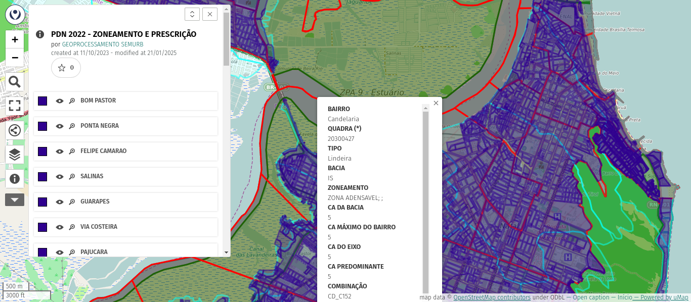
[1] uMap of the Natal’s zoning and urban planning (Rio Grande do Norte, Brazil) | © SEMURB | Map data © OpenStreetMap contributors.
About us
- Raquel Dezidério Souto, one of the editors of weeklyOSM’s Brazilian Portuguese edition, is carrying out a statistical survey of the content published in weeklyOSM over the last 10 years, since it became a multilingual publication (with 15 languages covered today). The research will serve as input for a chapter in her new book, to be released in August 2025. The issues considered are from WN272 to WN768, as of the publishing with the support of the OSMBC. Some results can be found on GitHub (licensed under GPL-3.0).
Mapping campaigns
- FixMyCity is seeking
 mappers to take part in a new paid project focused on collecting parking space data across Berlin. Using JOSM, participants would contribute to detailed mapping efforts as part of this initiative. The project is set to begin in May and is expected to run through to the end of the year.
Community
- Gregory Marler has released a new vlog documenting his ongoing efforts to create a comprehensive map of Dundee (Scotland). Utilising the OsmAnd application for GPS tracking, his phone’s camera for visual documentation, and Every Door for on-the-ground editing, Marler is meticulously recording house numbers and other local details. He then processes this data on his computer using JOSM to geolocate the captured photos and further refine the OpenStreetMap data.
- A recent episode of the ‘Tent Talks’ podcast (Episode 90) featuring hiker Christine Thürmer has sparked discussion regarding the commercial use of OpenStreetMap data by popular apps. Thomas Neubauer noted that Thürmer criticised platforms Komoot and Outdooractive during the podcast, alleging they sell expensive access to freely obtained OSM map data, while praising the Waymarked Trails initiative as a contrasting example.
- At the Free Culture conference, hosted by Rey Juan Carlos University in Fuenlabrada, MedioMultimedia sat
 ►
► down with longtime OpenStreetMap contributors Iván Sánchez and Miguel Sevilla for an in-depth interview.
 - At a recent OpenStreetMap London pub gathering, Harry Wood recounted discussions among community members on several key topics, including the ongoing legal challenges for the OpenStreetMap India community, a comparison of popular OSM mobile editing applications, and the idea of a ‘notathon’ mapping party to collaboratively address the backlog of unprocessed local OSM notes.
- Kumakyoo, in his sixth post about his newly developed OpenStreetMap file format ‘OMA’, delved into various alternatives for tackling the bounding box optimisation problem inherent to the OMA file format while also highlighting that the criteria for determining an optimal set of bounding boxes for OMA files remains an open question.
Events
- The OSM Local Chapters and Community Working Group has released the recordings of the OSM Local Chapters and Communities Congress 2025, which took place on Saturday 15 March.
- The State of the Map Latam 2025 organising committee is calling for academic presentations from the community until Thursday 15 May. Talk and workshop proposals
 ► can also be submitted. The event will be held 100% in person (without an online component), in Medellín, Colombia.
 - Are you a creative designer passionate about open mapping, geospatial innovation, or simply want your work seen on a national stage? The State of the Map Nigeria 2025 is calling on graphic designers and creative minds to design an iconic logo that will represent this year’s national conference, to be held in Enugu State, Nigeria. The deadline for the submission is Wednesday 30 April. Please follow the key recommendations and submit your design. The selected design will be featured on all SotM Nigeria 2025 materials, with full credit to the designer and special recognition at the event!
- On Saturday 15 March a webinar ‘Maps in Wikiprojects and in our lives’ was held online, organised by Wikimedia Ukraine, according to Andrii Holovin’s post on BlueSky.During the webinar, Andrii Holovin (a long-time OSM participant from Ukraine) and Anton Obozhyn (a Wikipedia contributor with extensive experience in mapping) presented:
- How maps are created and used: a basic introduction.
- Practical demonstration of the use of maps in wikiprojects.
- How to join the OpenStreetMap project and make your first contribution.
You can watch the webinar recording on YouTube
.
 online, organised by Wikimedia Ukraine, according to Andrii Holovin’s
 Maps
- [1] The Natal Municipality (Brazil) maintains ► a uMap with public information on the city’s zoning and urban planning regulations.
- During a 37 km cycling tour around Schwerin, Memo contributed several new range markers to the MeshCore map – a growing community-powered wireless mesh network that enables decentralised, long-range communication without relying on conventional internet infrastructure including cell towers or Wi-Fi. The newly added markers indicate the maximum distances at which devices can still maintain communication with a signal-to-noise ratio of approximately 1 dB, offering valuable real-world data on the network’s performance limits.
 ►
►OSM in action
- The Violence Index (Våldsindex) is a tool used to track [se]► the prevalence of serious violent crimes across Sweden. Compiled from incidents reported by the Swedish Police Authority’s press service, the index is presented through an interactive Leaflet-based map using OpenStreetMap data. Crimes are categorised into key types including shootings, murders, attempted murders, and explosions.
Licenses
- Preston Maness pointed out a striking similarity between the map rendering in promotional material for Google’s new ‘Geospatial Reasoning‘ product and OpenStreetMap’s default Carto style. Preston argues this resemblance constitutes a clear violation of the Open Database License (ODbL), specifically designed to prevent Google’s direct use of OSM data in customer-facing products, asserting that utilising AI for this purpose does not negate the licence infringement.
Software
- Lat x Lon shared Cameron Kruse’s ‘Tippecanoe Command Generator’, a web-based graphical interface designed to simplify the process of converting geospatial data into vector tiles using Tippecanoe.
Programming
- Tlohde released a tutorial detailing how to embed Leaflet maps into web pages.
- Paolo Melchiorre published a step-by-step guide on building a web-based map featuring images, using the Django web framework and its GeoDjango module. It also incorporated Pillow, the Python imaging library, to extract GPS data embedded in the images.
- Frederik Ramm announced the release of ‘Postpass’, a new public service enabling users to query the OpenStreetMap database directly through PostGIS. Frederik explained the rationale behind the tool, acknowledging the utility of Overpass for certain tasks while highlighting the familiarity and ease of SQL for users with experience in PostGIS.
Releases
- The GIScience Research Group at Heidelberg University and HeiGIT announced the release of version 1.0.0 of ohsome-planet, as reported by Spatialists. This new tool provides cloud-native access to OpenStreetMap data by utilising the GeoParquet format.
- Version 3.0.3 of uMap has been released, incorporating several fixes and user interface enhancements. This new version has already been deployed on the OpenStreetMap FR instance.
Did you know that …
- … Geoapify published a short tutorial showing three ways to get OpenStreetMap data on their blog in May 2022?
- … you can get a geo: link of the currently viewed map on OpenStreetMap via the ‘Share’ button?
Other “geo” things
- Reporting from the National Association of Broadcasters show, Jeff Geerling highlighted a Broadcast Positioning System demonstration, suggesting its potential as a valuable backup for the widely used GNSS.
- The European Commission and the EMODnet Bathymetry consortium has published a new release of their EMODnet Bathymetry digital terrain model, with an improved resolution of 1/16 × 1/16 arc minutes (approximately 115 × 115 metres), covering European seas and selected global regions. It integrates data from acoustic surveys, airborne bathymetric LiDAR, and satellite-derived bathymetry from platforms such as Sentinel-2.
- MapHub is a web portal for GIS users to host, visualise, and share geospatial datasets.
- Members of the Organic Maps contributor community have voiced growing concerns over the project’s governance and transparency, particularly around the potential for shareholder profit to take precedence over community interests. Contributors are calling for a transition to a non-profit structure, more inclusive decision-making processes, and clearer financial transparency. If these issues remain unaddressed, some members say they are prepared to launch a separate project to uphold these values.
- The Ordnance Survey, the national mapping agency for Great Britain, has funded research revealing a significant rise in mountain rescue callouts. The report attributes the surge in incidents to the influence of social media and the use of subpar digital mapping applications. As a precaution, the agency encouraged anyone planning to venture into remote areas to download the OS Maps app and carry a paper map, advising that this combination would ‘guarantee yourself a wonderful adventure without getting stranded or lost’.
- Wikimedia Deutschland has developed wikidata-map, an interactive web map that shows the global density of Wikidata items, offering users an intuitive way to explore the geographical distribution of structured data from Wikidata.
Upcoming Events
| Country | Where | What | Online | When |
|---|---|---|---|---|
 | Mumbai City | 2nd Mumbai Mapping Party | 2025-04-20 | |
 | Aketi | Mapathon for Kinshasa City | 2025-04-21 – 2025-04-25 | |
 | Hannover | OSM-Stammtisch Hannover | 2025-04-22 | |
| Kiel | Kieler Mapper*innentreffen | 2025-04-22 | |
 | Derby | East Midlands pub meet-up | 2025-04-22 | |
| Missing Maps – DRK & MSF Online Mapathon | 2025-04-23 | |||
| [Online] OpenStreetMap Foundation board of Directors – public videomeeting | 2025-04-24 | |||
 | Zaragoza | Mapatón Humanitario Universidad de Zaragoza | 2025-04-24 | |
| Atelier – mapathon: évaluation post-cyclonique des dommages aux bâtiments | 2025-04-24 | |||
| UN Mappers Mappy Hour | 2025-04-25 | |||
| SOSM Annual General Assembly | 2025-04-25 | |||
| OSMF Affiliation Focus Group Discussion: Thematic and non-geographical groups | 2025-04-26 | |||
 | 斗南鎮 | 雲林六房天上聖母土庫、虎尾維基街景資料工作坊 | 2025-04-27 | |
 | Saint-Étienne | Rencontre Saint-Étienne et sud Loire | 2025-04-28 | |
| Korbach | Wheelmapevent Stadt Korbach + Landkreis Waldeck-Frankenberg | 2025-04-29 | |
 | San Jose | South Bay Map Night | ✓ | 2025-04-30 |
| Rostock | Rostocker Treffen | 2025-04-30 | |
| Düsseldorf | Düsseldorfer OpenStreetMap-Treffen (online) | 2025-04-30 | |
 | Wien | 74. Wiener OSM-Stammtisch | 2025-04-30 | |
| OSMF Engineering Working Group meeting | 2025-05-02 | |||
| Alipur Tehsil | 16th OSM Delhi Mapping Party (Online) | 2025-05-04 |
Note:
If you like to see your event here, please put it into the OSM calendar. Only data which is there, will appear in weeklyOSM.
This weeklyOSM was produced by PierZen, Raquel Dezidério Souto, Strubbl, Supaplex, TheSwavu, barefootstache.
We welcome link suggestions for the next issue via this form and look forward to your contributions.