07/11/2017-13/11/2017
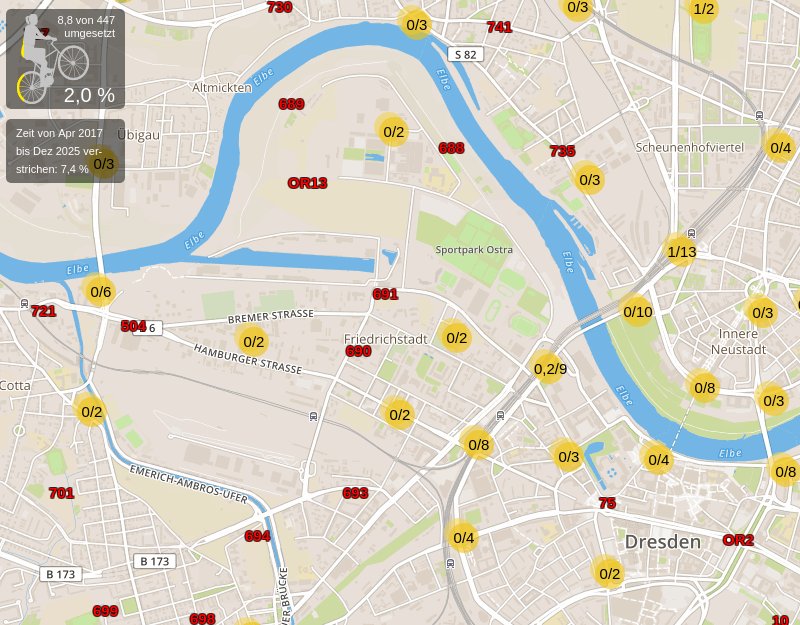
The ADFC (German Cyclist Association) holds a mirror map up to the administration in Dresden, Germany. 1 | © Mapbox, © OpenStreetMap Mitwikende, oDbL © Nils Larson
Mapping
- Yuri Astrakhan re-started the discussion on the Talk mailing list about the tool to do mechanical edits (it is now called Sophox). Yuri is perceived by many as unreasonable as before and tries to ignore all the unwritten rules in OSM.
- Enrico asks on the Tagging mailing list how to tag a religious mural painting, „Affresco votivo“ in Italian.
- Through a Twitter moment, user sev_osm showcased over 10 outreach and training workshops on CarteInnov run by Les Libres Geographes (LLG) and local OSM mappers. This project supported by International Organization of Francophonie (OIF) aims at building an open map of Digital Innovation stakeholders in Haiti, Madagascar and 12 African countries. The data is hosted in OSM and edited with MapContrib.
- You can cast your vote on the revised version of the Fire Hydrant Extensions proposal until November 27th. The original version did not achieve the required majority.
- The voting of the proposal Metro Mapping has started and will end on November 24th. Several people including companies which already map stations criticize the proposal on the Tagging mailing list.
- Gabe Appleton presents his suggestion for the timing of traffic lights and expects constructive criticism.
- BeKri complains
 (automatic translation) in the German forum about a remarkably large number of new Wheelmap users in Munich, who very often enter POIs twice or place them at wrong locations. Holger from Wheelmap promises a new editor which can only edit
 wheelchair=*andtoilet:wheelchair=*tags.
 (automatic
 Community
- The developers of Jungle Bus shares a tweet on Twitter for help to translate their app.
- The Atom Feed interface of Pascal Neis Suspicious OpenStreetMap Changesets has now got the optional
bboxparameter. The parametercountrycan then be omitted. (Source) - User ChristianA wrote a blog post about the drawbacks of open data. The lack of outdoor and more armchair mapping.
- An incorrect wikidata link in OSM caused an area of the Bronx to be mislabelled on Mapbox Vector tiles.
- Kathmandu Living Labs invited the current Women Leaders in Technology ([WLiT(http://wlit.org.np/)) fellowship holders to join a special OSM session. Participants gained their first experiences in the use of OSM through hand-on mapping. They also had a chance to learn about mapping and OSM, as well as possible ways to contribute to the global OSM database.
- Sterling Geo describes in their blog how they compared Sentinel-2 data with OSM land use data.
Imports
- The company Cybo which operates a yellow pages directory wants to offer its POI data to OpenStreetMap. There are two parallel threads on the Imports and Talk-us mailing list. the coordinates seem to be retrieved using Google’s geocoding API and cannot be used by OSM due to legal reasons.
OpenStreetMap Foundation
- Just less than three years ago, a member-initiated initiative proposed to reorganize the terms of office for OSMF board members and limit the terms of office. Simon Poole writes to the Osmf-talk mailing list about getting a clear statement from the board on addressing this in 2018
- Data Working Group has published its activity report (PDF) for the third quarter of 2017.
- Members of FOSSGIS e.V., the de-facto local OSM chapter in Germany, discuss about a grant application (automatic translation) to sponsor a secondary production server for the German instance of the Overpass API (overpass-api.de).
- This year’s meeting of the OSM Foundation members will take place on December 9th via IRC. Details can be found in the invitation email. Two new board members must be elected. OSMF members can register as candidates until November 25th. Details on the elections in the OSM-Wiki, and there is also a page for voter questions.
Humanitarian OSM
- HOT calls out an acitivation due to the Iran-Iraq earthquake.
- John Whelan inquires on the HOT mailing list to assist in testing building mapping projects in Malawi.
- OSM Zambia received a „microgrant“ from HOT that made it possible to carry out extensive mapping training in Zambia’s schools.
- HOT has published a call for applications for a position to develop a mapping visualisation tool which creates videos visualising edits in an area. Application deadline is 17th November.
- A BBC radio feature talks about Missing Maps, mapathons, armchair mapping, Red Cross, mapping buildings, roads, and rivers.
Maps
- Developers of OSM Carto discuss if restaurants, pubs, and similar amenities should be rendered as small brown squares on zoom level 17 as it already happens with most shops (in pink).
- [1] The ADFC (member of the ECF) tries to use an OSM based map to get the Dresden administration to do more for cyclists. Nils Larsen, the author of the map, has announced a „how to“ post which will be published shortly.
- User Komzpa submitted a pull request to OSM Carto which adds rendering of
place=*on areas. Some people fear that it supports the duplication ofplace=*tags in OSM (currently mainly mapped on nodes).
Software
- Pieter Vander Vennet shows how to write your own OsmAnd routing profile.
Programming
- Richard Fairhurst describes in his user diary how to debug Lua scripts of Osm2pgsql and OSRM without re-running a time consuming import each iteration.
Did you know …
- … that you can create new nodes in JOSM while you are in the extrusion mode (key X) by doing a double-click? It saves pressing A and X. (via a thread in the German OSM forum)
- … Latest Changes on OpenStreetMap by Martin Raifer? It shows all changed objects in the last seven days in an area.
Other “geo” things
- CityLab reported: London’s Oxford Street will become a pedestrian zone. 800m of traffic will be closed to vehicles by 2018. This fact is also a challenge for OpenStreetMap.
- An interview by MARTECHSERIES with Javier de la Torre, the founder of CARTO (including the basic map of OSM).
- In its latest issue, the Spanish online magazine NOSOLOSIG reports on the first maps of the Palaeolithic period. The map carved in a stone, which clearly contains geographical references, was found during excavations in the cave of Abauntz near the village of Arraitz about 20 km north of Pamplona, Spain, and is therefore called „the map of Abauntz“. A translation of the article with deepl is worthwhile. 😉 (automatic translation)
- Gulf News reports that the 2nd „Louvre“ was opened in Abu Dhabi. Of course, it is already recorded in OSM. The tagging is obviously still not complete. 😉
- Theodolite, an app for „Augmented Reality“, which according to prMac contains excellent OSM data even in „the middle of nowhere“ is coming for iPhone X.
- A tourist from Milan got stuck with his vehicle in a medieval alley in Como because he trusted his satnav more than his eyes. The map data was not from OpenStreetMap, but the incident inspired the local OSM comunity to recheck the area for possible mistakes.
 (automatic
 Upcoming Events
| Where | What | When | Country |
|---|---|---|---|
| online via Mumble | OpenStreetMap Foundation public board meeting | 2017-11-16 |  |
| Digne-les-Bains | Cartopartie : Libre information sur les services de santé | 2017-11-16 |  |
| Fort Collins | CSU Ger Community Mapping Center Mapathon Colorado State University | 2017-11-16 |  |
| Suzhou | OpenStreetMap Youth Promotion | 2017-11-18 |  |
| Helsinki | HOT-OSM Finland Geoweek Mapathon 2017 | 2017-11-18 |  |
| Brazil | Brasília OpenStreetMap Edit challenge begins with a focus on road characteristics | 2017-11-19 |  |
| London | Raincatcher Mapathon for Tanzania | 2017-11-21 |  |
| Lüneburg | Mappertreffen | 2017-11-21 |  |
| Nottingham | Pub Meetup | 2017-11-21 | |
| Edinburgh | Pub meeting | 2017-11-21 | |
| Viersen | OSM Stammtisch Viersen | 2017-11-21 | |
| Lübeck | Lübecker Stammtisch | 2017-11-23 | |
| Apach (Moselle) – Schengen (Luxembourg) – Perl (Saarland) | 1. OpenSaar-Lor-Lux Stammtisch | 2017-11-24 | |
| Bremen | Bremer Mappertreffen | 2017-11-27 | |
| Bonn | 100! Bonner Stammtisch | 2017-11-28 | |
| Brussels | Missing Maps @ MSF/HI | 2017-11-28 |  |
| Dusseldorf | Stammtisch | 2017-11-29 | |
| Lima | State of the Map LatAm 2017 | 2017-11-29-2017-12-02 |  |
| Yaoundé | State of the Map Cameroun 2017 | 2017-12-01-2017-12-03 |  |
| Dar es Salaam | State of the Map Tanzania 2017 | 2017-12-08-2017-12-10 |  |
| Rome | FOSS4G-IT 2018 | 2018-02-19-2018-02-22 |  |
| Bonn | FOSSGIS 2018 | 2018-03-21-2018-03-24 | |
| Poznań | State of the Map Poland 2018 | 2018-04-13-2018-04-14 |  |
| Milan | State of the Map 2018 (international conference) | 2018-07-28-2018-07-30 | |
Note: If you like to see your event here, please put it into the calendar. Only data which is there, will appear in weeklyOSM. Please check your event in our public calendar preview and correct it, where appropriate.
This weeklyOSM was produced by Nakaner, Polyglot, SK53, Softgrow, Spanholz, Spec80, YoViajo, derFred, jinalfoflia, sev_osm.
Hi,
This link seems to be broken to me:
([WLiT(http://wlit.org.np/))
I would like you to mention this proposal for public transport:
https://wiki.openstreetmap.org/wiki/Proposed_features/Differentiation_for_routes_of_public_transport