09/13/2016-09/19/2016
 1 |
1 |
Mapping
- Jothirnadh explains in his user diary how one can revert changesets in JOSM that would normally trigger a timeout.
- Christoph Hormann analyzed data quality in the Canadian Arctic and compared it to Greenland in his blog post entitled „OpenStreetMap at its worst“.
- Michael Tsang suggests a new relation in his proposal for „Through Services“.
- Johnw asks how one could tag an amphitheatre.
- Greg wants to add some more stats for the upcoming quarterly project and asks for help on Github.
- Edits by Telenav employees with the quality assurance tool ImproveOSM are seen very critically by the Canadian Community. User Mihai Iepure requests to provide a short summary of the emails in English as he does not know French.
- Adam Old, member of a „Tree Board“ in South Florida asks if they may use OpenStreetMap for their collection of trees and meta data of those trees.
- Denis Stein asks on the OpenRailwayMap mailing list where exactly and how to map points (switches, turnouts), and makes some suggestions.
- Jojo4u asks if
railway=technical_stationis obsoleted byrailway=service_station. - Analysing MAPS.ME changesets, manoharuss found several typical rookie mistakes but surprisingly little misuse of
name=*. - Krishna Nammala from Mapbox Data Team reported the German forum on the status of their efforts to „missing turn restrictions“ in Germany.
- Jojo4u created a new proposal for tagging mud flat trails.
- Srividya from Mapbox Data Team reported a notable data offset of 15-20 meters with respect to GPS Traces in Taiwan. Mapbox has therefore provided new satellite images for the larger cities.
Community
- Joe Morris is a cyclist and interested in public drinking water spots and created a map for that. To increase the data he’d like to create a dedicated site to map such locations and therefore asks for feedback.
- Søren Johannessen notes that OpenStreetMap reached 200 million buildings in its data base.
Imports
- Gianmario Mengozzi proposes on the import mailing list a boundary Import in the northern Italian region of Emilia-Romagna from a CC-0-licensed source.
Maps
- The application Gnome Maps slowly starts to get usable. After the end of MapQuest Open they started to use Mapbox tiles, they now have aerial imagery, a very basic search function and a routing based on Graphhopper.
- GeoHipster will again be publishing a calendar in 2017. For that they have asked to send in the maps that might be included in the official calendar.
- Hans Hack created a poster of the 104 islands in the German capital Berlin.
- The OSM Carto developers plan to switch to Noto, a new font. They ask for feedback from readers of Asian countries.
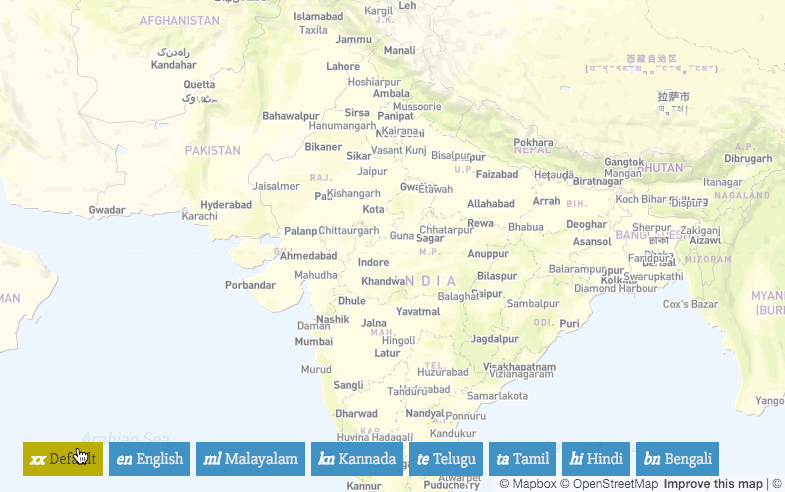
- [1] Thej from India analyzes in his blog, the consideration of Indian languages in OpenStreetMap (Mapnik). Arun Ganesh points among others to the multilingual map by Jochen Topf and his own experiments.
switch2OSM
- It is evident, that Pokémon Go uses OSM data.
Software
- The OsmAnd maps of September 1st initially ignored turn restrictions. This issue has been fixed, newer maps contain turn restrictions.
Programming
- Ircama did publish tutorials on how to setup your environment if you want to participate in OSM Carto development.
- Andy Allan asks for help to refactor the original ruby on rails code of the OSM-API.
- Paul Norman would like to register MIME types for our OSM file formats.
- Geofabrik now provides separate extracts of every country in Africa on their download server.
Releases
| Software | Version | Release date | Comment |
|---|---|---|---|
| Nominatim | 2.5.1 | 2016-08-02 | Bug fix release with minor fixes |
| SQLite | 3.14.2 | 2016-09-12 | Six fixes |
| Osmose Backend | v1.0-2016-09-13 | 2016-09-13 | No info |
| QMapShack Lin/Mac/Win | 1.7.1 | 2016-09-14 | No infos |
| libosmium | 2.9.0 | 2016-09-15 | see below |
| Osmium Tool | 1.4.0 | 2016-09-15 | Eight extensions, six changes and 2 fixes |
| Overpass-Turbo | 2016-09-15 | 2016-09-15 | Fixed GPX output format, support portuguese, some other fixes |
| PyOsmium | 2.9.0 | 2016-09-15 | Adjustments to actual libosmium |
| Magic Earth * | 7.1.16.37 | 2016-09-16 | Eliminates GPS problems, improved audio via Bluetooth, further changes and improvements |
| Komoot Android * | var | 2016-09-17 | No info |
| Naviki Android * | 3.48 | 2016-09-19 | Layout revised |
| OsmAnd for Android * | 2.4 | 2016-09-19 | Improved user interface, refined POI search |
| OsmAnd+ for Android * | var | 2016-09-19 | Improved user interface, refined POI search |
Provided by the OSM Software Watchlist.
(*) unfree software. See freesoftware.
Jochen Topf announces the new features of libosmium 2.9.0 and Osmium-Tool 1.4.0 in his blog. The latter now also allows to change tags with sed and generates human readable diffs.
Did you know …
- … the Francophone project „Espace OpenStreetMap Francophone“ where Nicolas Chavent trains mapper in West Africa?
- … Martin Raifer’s map of the node density in OpenStreetMap?
Other “geo” things
- Both Forbes and TechCrunch Network report on the technical assistance, that has done inter alia OpenStreetMap Italy after the earthquake.
- Paul Groves explains how 3D-Mapping could be used to enhance the accuracy of GNSS in cities. As a data source for the needed 3D models he suggests to use OpenStreetMap data.
- Peter Richardson of Mapzen reported in his blog post as he generates 3D models with Heightmapper from Mapzen’s high-quality open-source terrain data.
Upcoming Events
| Dónde | Qué | Fecha | País |
|---|---|---|---|
| Brussels | HOT Summit 2016 | 22/09/2016 |  |
| Brussels | HOT Summit Missing Maps Mapathon | 22/09/2016 | |
| Brussels | State of the Map 2016 | 23/09/2016-26/09/2016 | |
| Grenoble | Rencontre groupe local | 26/09/2016 |  |
| Nottingham | Nottingham | 27/09/2016 |  |
| Kyoto | 京都オープンデータソン2016 vol.2(吉田神社) with 第1回諸国・浪漫マッピングパーティ | 01/10/2016 |  |
| Trento | Mapping Party Pieve Tesino | 01/10/2016-02/10/2016 |  |
| Genova | Mappalonga Mapathon | 01/10/2016 | |
| Metro Manila | State of the Map Asia 2016 | 01/10/2016-02/10/2016 |  |
| Taipei | Taipei Meetup, Mozilla Community Space | 03/10/2016 |  |
| Dresden | Elbe-Labe-Meeting | 08.10.2016-09.10.2016 |  |
| Lyon | Rencontre mensuelle mappeurs | 11/10/2016 | |
| Berlin | Hack Weekend | 15.10.2016-16.10.2016 | |
| Tokyo | 東京!街歩き!マッピングパーティ:第1回 哲学堂公園 | 15/10/2016 | |
Note: If you like to see your event here, please put it into the calendar. Only data which is there, will appear in weeklyOSM. Please check your event in our public calendar preview and correct it, where appropiate..
This weekly was produced by Hakuch, Nakaner, Peda, Rogehm, Softgrow, YoViajo, derFred, jinalfoflia, kreuzschnabel, mgehling, wambacher.